Sunday turned out to be a decent little chase for hail, structure and lightning at dusk in northwest TX.
Leaning a bit on CAMs, we were tempted to get as south and west as possible (Clovis or so) in hopes of cells keeping discrete and having better moisture. Fatigue from Friday in eastern KS. was still an issue and we had no intent to chase the messy looking event in OK Monday, so this would be an out and back to CO. We settled on any storms within 6 hours.
By mid morning, surface observations had really awful dews (30s) from TX panhandle, getting even worse to the north. Colorado had a upper 20s or low 30s. Moisture advection north looked like it would make up at best 10-15 degrees throughout the day by initiation; indeed we chased in mid 40s dews. The HRRR was extremely consistent over many runs with some nice helicity tracks south of Boise City, and the deeper moisture had made it that far north by late afternoon, so we went for that area.
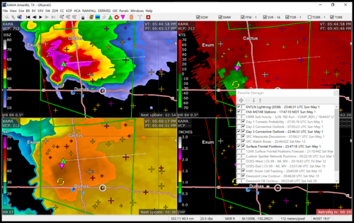
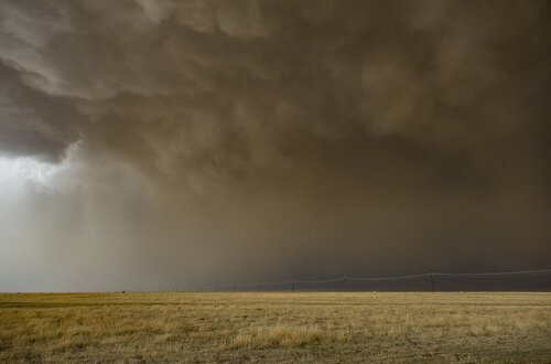
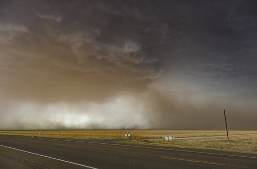
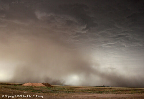
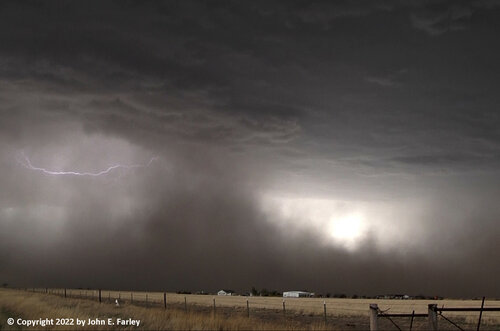
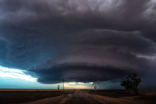
Ended up chasing a classic looking cell near Dumas, with loose hook echo and constant TVS and meso signatures that was only briefly tornado warned near town. Never really tightened up further. Dust was a major factor in visibility and from southeast of the hook we couldn't see anything but dust and a rough outline of a probable wall cloud. Moved southwest of the hook hoping for the air to clear, and followed along behind and found some nice hailstones up to nearly golf ball size. Visibility only got slightly better and the storm was getting interrupted now by adjacent development. We ended up bailing to tail end storms. By the third storm the dust had been mostly layed down in the area by precipitation. Things were getting slightly clustery but at least not totally linear. We happily found an isolated cell near Masterson, TX. at dusk that made the chase feel worth it. Nice classic shape with hook, clear path for inflow, and consistent updraft strength and lightning. The storm wound down with pretty structure and nice CGs that were cleverly timed by the storm to always be between my intervalometer opening the camera shutter. Road network between Dumas and AMA is not the best unfortunately so we got the views we could.
Conclusion: a fun day with medium levels of effort and gas used. Didn't see the Fort Stockton tornado, but don't chase for just tornadoes and don't regret any of our choices.
2022 western plains first new lesson learned: be prepared to see nothing or wait until enough rain has fallen to clear out dust.
Slowly dwindling supercell at dusk near Masterson, TX.
Radar of first supercell near Dumas shortly after we dropped down ahead of it and started trying to see it through dust a wall of dust.

Leaning a bit on CAMs, we were tempted to get as south and west as possible (Clovis or so) in hopes of cells keeping discrete and having better moisture. Fatigue from Friday in eastern KS. was still an issue and we had no intent to chase the messy looking event in OK Monday, so this would be an out and back to CO. We settled on any storms within 6 hours.
By mid morning, surface observations had really awful dews (30s) from TX panhandle, getting even worse to the north. Colorado had a upper 20s or low 30s. Moisture advection north looked like it would make up at best 10-15 degrees throughout the day by initiation; indeed we chased in mid 40s dews. The HRRR was extremely consistent over many runs with some nice helicity tracks south of Boise City, and the deeper moisture had made it that far north by late afternoon, so we went for that area.
Ended up chasing a classic looking cell near Dumas, with loose hook echo and constant TVS and meso signatures that was only briefly tornado warned near town. Never really tightened up further. Dust was a major factor in visibility and from southeast of the hook we couldn't see anything but dust and a rough outline of a probable wall cloud. Moved southwest of the hook hoping for the air to clear, and followed along behind and found some nice hailstones up to nearly golf ball size. Visibility only got slightly better and the storm was getting interrupted now by adjacent development. We ended up bailing to tail end storms. By the third storm the dust had been mostly layed down in the area by precipitation. Things were getting slightly clustery but at least not totally linear. We happily found an isolated cell near Masterson, TX. at dusk that made the chase feel worth it. Nice classic shape with hook, clear path for inflow, and consistent updraft strength and lightning. The storm wound down with pretty structure and nice CGs that were cleverly timed by the storm to always be between my intervalometer opening the camera shutter. Road network between Dumas and AMA is not the best unfortunately so we got the views we could.
Conclusion: a fun day with medium levels of effort and gas used. Didn't see the Fort Stockton tornado, but don't chase for just tornadoes and don't regret any of our choices.
2022 western plains first new lesson learned: be prepared to see nothing or wait until enough rain has fallen to clear out dust.
Slowly dwindling supercell at dusk near Masterson, TX.

Radar of first supercell near Dumas shortly after we dropped down ahead of it and started trying to see it through dust a wall of dust.
