2022-04-10 to -14 EVENT: KS/OK/MO

Joined
Feb 19, 2021
Messages
649
Location
Wichita
If the 12Z ECMWF is correct, there will be the most impressive Central Plains multi-day event in years.

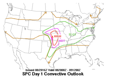
From a pattern recognition perspective, it reminds me of May 3-8, 2003. The model's surface forecast is especially similar to May 8, 2003, but 2022 is, perhaps, 50 miles farther south based on that model's surface forecast. Both events show a strong negatively-tilted wave over the southern Rockies. The 2003 20Z SPC outlook is nearby. The SPC case history is here: SPC Severe Weather Event Review for Thursday May 08, 2003

The forecasted 2022 event has CAPE of 3,000+j and SWEAT of 700+, which is an extreme value. 250mb winds of 138kt are forecasted to overlay the area.

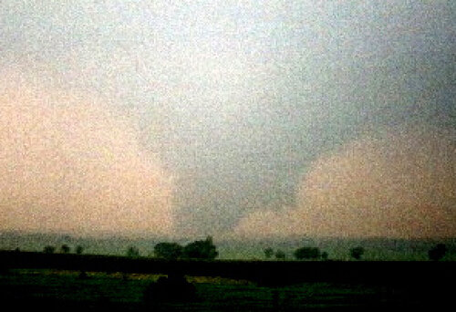
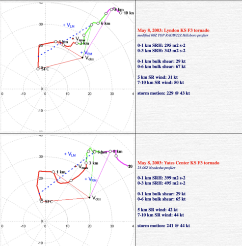
I have attached a photo of the F-3 Lyndon-Lawrence Tornado from 5-8-03. There were horizontal vortices, so the tornado might be underrated. The photo was taken through pouring rain from the supercell that produced the F-3 Yates Center Tornado. Hodographs are nearby.

My starting this thread is not to say there will be a high risk issued. I don't attempt to forecast what SPC might or might not forecast.

My primary reason for starting this thread is to provide some coaching info for young chasers who have not chased this type of event in the Great Plains.
  • Two days of the 2022 ECMWF look almost exactly like May 8.
  • In situations like this, you will likely have to pick a single supercell as the storms will move ~50-55 mph.
  • Tail-end charlie, with both kinematics and thermodynamics forecasted to be this strong, will not necessarily be the best choice. I'd choose just NE of any dry line mesolow and/or a cell on the warm front.
  • The ECMWF, this far out, has an east bias of about 50 miles.
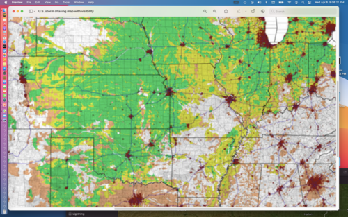
  • If possible, pick the "green" areas on the StormTrack road + visibility map. Green area looks well-matched to the threat on the final day (14th).
  • Wichita, other factors equal, is probably the best airport to fly into if you are using that mode of transportation.
Of course, things can/will change.
 

Attachments

  • Screen Shot 2022-04-06 at 9.34.04 PM.png
    Screen Shot 2022-04-06 at 9.34.04 PM.png
    122.2 KB · Views: 0
  • 5-8-03 Lyndon-Lawrence Tornado.jpg
    5-8-03 Lyndon-Lawrence Tornado.jpg
    245.6 KB · Views: 0
  • Screen Shot 2022-04-06 at 9.31.13 PM.png
    Screen Shot 2022-04-06 at 9.31.13 PM.png
    134.2 KB · Views: 0
  • Screen Shot 2022-04-06 at 9.08.21 PM.png
    Screen Shot 2022-04-06 at 9.08.21 PM.png
    2.7 MB · Views: 0
  • Screen Shot 2022-04-06 at 9.47.21 PM.png
    Screen Shot 2022-04-06 at 9.47.21 PM.png
    658.5 KB · Views: 0
Last edited:
Well done Mike. I was wondering who would be the first to dive into this one. The only difference I have is the storms moving a little slower on Monday and Tuesday. I’m glad it’s during the week and not a weekend. Crowded rounds are probably not the best time to knock the rust off.
 
Nice to see someone tackle this so early.

From a pattern recognition standpoint, a few of us this far north (MN/IA) are :oops: at historical analogs. Still too much jumping around with features on individual model runs to get too excited but, with a "primer" system on Sunday to get moisture return started, and with Monday/ Tuesday "days before the day", Wednesday with a deepening low and a warm front laid out generally east to west across the upper midwest somewhere, this is getting harder to ignore. And it's not often to see a day 8 slight risk outlook like we had yesterday.

Too much model agreement to not perk up a little.

The 12z Canadian today is something else...
 
Unfortunately it's spring break and not many options to chase this (unless you live in the central USA). Looks like a decent first setup although the storm motions may be a bit high.
 
Quite a bit of difference between ECMWF and GFS as of today. (4/7)

With the 12z ECMWF you have the triple point setting up approx over OK panhandle Mon and Tue, with the main thrust of the mid level energy still in the offing. On Wed the trough arrives across C KS and produces a highly sheared (albeit rather unidirectional given the low's positioning) environment.

GFS is way more progressive with this, showing only Tuesday as a day of interest and putting the trough over the Ohio Valley by midday Wed.

SPC seems to like the ECMWF better as of right now; although the latest ECMWF, thankfully, seems a bit slower.

This could be a 3 day event, but I have my doubts on the timing of things Monday. Tuesday has the look of the "day before the day" that actually gives you chasable stuff. Wednesday being the bomb out day that often enough is a tough chase in early spring.

But we're a number of days out, so this is just spitballin'.
 
I know it's dangerous to toss any one model, but the GFS seems to be up to its usual tricks and progressing things of this magnitude way too quickly. I expect it to start to sort things out and slow down in the next few runs. Euro and Canadian are basically in lock step with minor differences for this range. Strong wording already from SPC.

Moisture isn't going to be a problem with the slower, deeper solutions. A very large, well-juiced warm sector looks to be on tap both Tuesday evening and especially Wednesday. Current outlooks obviously only cover the most favored southern areas but I would expect to see fairly decent severe probs eventually across Iowa and if the Canadian is correct, even far southern Minnesota.
 
Last edited:
Based on the 12Z Friday models, Tuesday is probably the day for those who wish to chase in the central Great Plains.

While the ICON is the farthest west with convective initiation (30 E MCK, HLC, WWD, HBR) and the ECMWF is farthest east (W of CNK, SLN, ICT, OKC), they are surprisingly consistent in a number of other ways. They all forecast >3000j of CAPE. There is difluence at 500mb over Kansas.

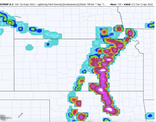
While the ECMWF is not an explicit convection-allowing model, it forecasts lightning. At 4pm Tuesday (nearby) there is abundant lightning forecast to occur with a "line in front of a line" structure.

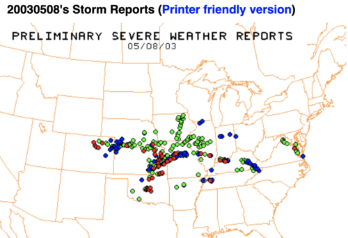
The "line in front of a line" structure was present April 26, 1991, May 3, 1999 and April 12, 2012. The easternmost storms in these situations are the more prolific tornado producers. On the date I mentioned when I started this thread (May 8, 2003), the thunderstorms to the west were quite weak while the storms to the east saw every supercell produce a significant tornado.

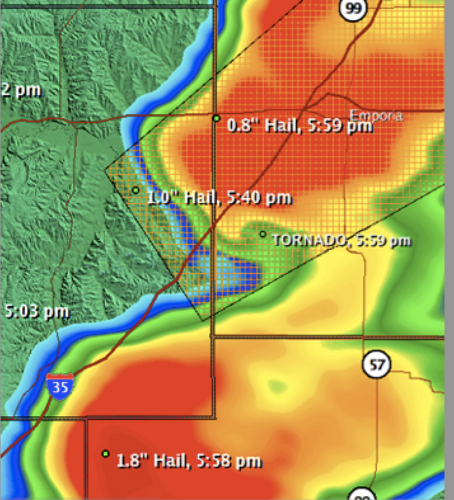
To be clear: I'm only trying to provide some context to the models for young meteorologists and chasers. IF (and it is a big if this far out) we should see something like the aforementioned dates, chasing gets very tricky because of rapid forward motion and the relatively small spacing between supercells. Unfortunately, I only have one small radar image from 5-3-03. It shows the supercells that produced Lyndon-Lawrence (F-3) and Yates Center (F-3). It was like this up and down the line. Note the heavy rain between the two storms.

Good luck with planning and any chasing you may plan to do.
 

Attachments

  • Screen Shot 2022-04-08 at 1.34.46 PM.png
    Screen Shot 2022-04-08 at 1.34.46 PM.png
    566.2 KB · Views: 0
  • SmartRad 5-8-03, Lyndon-Lawrence Tornado.png
    SmartRad 5-8-03, Lyndon-Lawrence Tornado.png
    396.8 KB · Views: 0
Quite a bit of difference between ECMWF and GFS as of today. (4/7)

With the 12z ECMWF you have the triple point setting up approx over OK panhandle Mon and Tue, with the main thrust of the mid level energy still in the offing. On Wed the trough arrives across C KS and produces a highly sheared (albeit rather unidirectional given the low's positioning) environment.

GFS is way more progressive with this, showing only Tuesday as a day of interest and putting the trough over the Ohio Valley by midday Wed.

SPC seems to like the ECMWF better as of right now; although the latest ECMWF, thankfully, seems a bit slower.

This could be a 3 day event, but I have my doubts on the timing of things Monday. Tuesday has the look of the "day before the day" that actually gives you chasable stuff. Wednesday being the bomb out day that often enough is a tough chase in early spring.

But we're a number of days out, so this is just spitballin'.
Spitballin' is essential for those of us on either coast, who must commit (gamble) two days lead-time to drive out, before we can even begin chasing.
 
SPC has upgraded Days 4 and 5 (Tuesday and Wednesday) to 30%. I don’t recall seeing that very often… Based solely on the SPC outlooked areas (I haven’t looked at data yet, since I can’t chase anyway…), the 30% areas are not in ideal chase territory, being mostly east of I-35. Have to hope that on Tuesday the dryline sets up further west than currently anticipated. Wednesday is squarely centered on Arkansas. Could be a situation where it’s worth looking at secondary targets in better terrain.
 
So Monday looks to be out, and Tuesday looks really interesting. Wednesday... we'll see.

But Tuesday. I probably need to become a bit more modern with my forecasting and become better acquainted with some of latest ensembles, but the GFS, ECMWF and now NAM (does anybody still use him or is he crazy now?) all point to the dryline setting up west of I-35. This makes me happy.

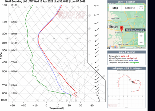
Also making me happy is the turning with height present across the warm sector; particularly across C KS into SE NE and SW IA later in the day. The NAM is throwing out some "tornadoey" 0-1 EHI figures. The simulated hodographs also look super tornadoey.

My biggest concern, I suppose, will be timing and placement of shortwaves & energy aloft to kick this thing off. Still a bit of worry on that, but, anything that goes up looks to have a pretty good environment, this as of midday 4/9/2022 CST.

1649530347302.png
 
Derek asked the question about the timing of shortwaves. It is a good question.

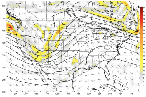
The Canadian, which I use as a middle of road model, has a 500mb height fall of 5.5 dm at KICT from 1pm to 7pm Tuesday. That is a major height fall for a six hour period of time. Perhaps more importantly, it comes from a negatively tilted, progressive short wave. I have attached the ECMWF 500mb chart forecast for Tuesday at 7pm.

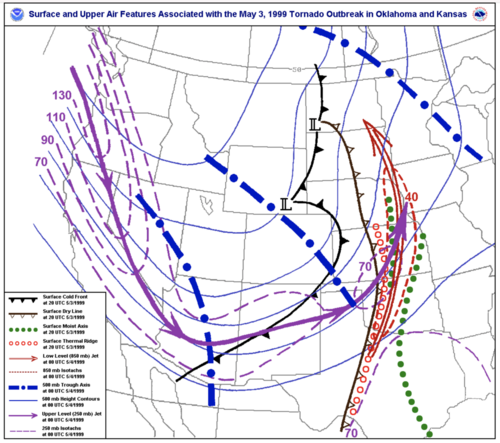
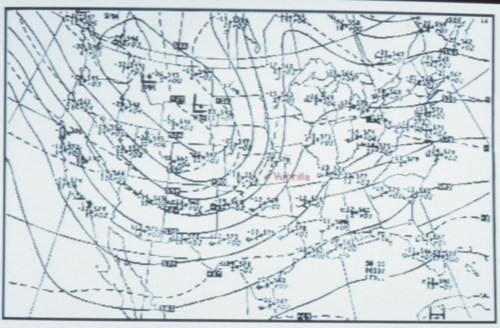
I am a big believer in pattern recognition, so I attach the composite chart for the Oklahoma-Kansas outbreak of May 3, 1999, and the 500mb chart for the Wichita-Andover Tornado outbreak of April 26, 1991. All three are negatively tilted, progressive short waves.

The various models have 3000 to 4200j of CAPE over south central Kansas. I mention our area (I'm based in ICT) because current models put the strongly difluence aloft over our area, which was the case for the Wichita-Andover Tornado. It goes without saying those values of CAPE, especially with April dynamics, are more than sufficient for a high-end event.

Finally, all of the models have falling pressures in Kansas and northern Oklahoma Tuesday afternoon. I have observed that falling pressures are a key ingredient when we are discussing a high-end event in the central Great Plains.

If the models are correct, this will be the biggest multi-state dryline-type tornado event that we have seen in the past decade.

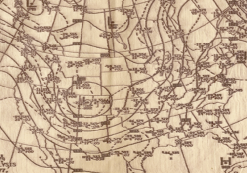
P;S. I added June 8. 1974, 500mb chart which featured a central and northeast Oklahoma outbreak as well as the F-4 tornado that struck Emporia, KS (warm front). This was a negatively tiled short wave that closed off as it crossed the Rockies.
 

Attachments

  • 00Z Tues.png
    00Z Tues.png
    1.4 MB · Views: 0
  • Composite chart, 7p May 3, 1999.png
    Composite chart, 7p May 3, 1999.png
    623 KB · Views: 0
  • 500mb April 26, 1991, 7pm.png
    500mb April 26, 1991, 7pm.png
    3.1 MB · Views: 0
  • Screen Shot 2022-04-09 at 4.16.09 PM.png
    Screen Shot 2022-04-09 at 4.16.09 PM.png
    1.3 MB · Views: 0
Last edited:
I only see one issue with this system and that is timing. I feel the system is just a tad bit to far to the west by Tuesday late afternoon/evening for an outbreak. however I still think there will be at the very least a few intense tornadic supercells between the red river of Oklahoma/Texas and SE Nebraska. There should be just enough of an upper wave coming through during the afternoon to help get a few storms going. Also as Mike has mentioned with diffluent flow aloft/falling heights and surface pressures/strong surface heating and convergence along dryline should pop a few cells. Anything that can develop and sustain should be VERY intense and likely produce tornadoes. We will not have a clear picture of the scope of storm development on the dryline for at least another 24 to 48 hrs. But after chasing hardcore all over the plains since 2004 and over 200 tornadoes later I have learned anytime you have a system like this(Pattern recognition/negative tilt progressive trough) you have got to pay VERY close attention. Will be interesting how the models handle this trough over the next couple days as we get data samples from the upper levels. Also another caveat will be the subtropical jet streak forecast to move through Texas and into Louisiana during the day Tuesday. This system could throw a wrench in the works. However it could also provide an interesting severe setup in central/Eastern Texas, southern Arkansas, Northern Louisiana Tuesday afternoon and evening. Just sucks the terrain down there sucks from a chasing perspective.
 
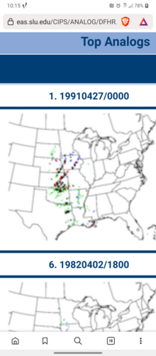
Thank you Mike for starting this thread and for your insights and historical perspective. You have been spot on. Convective allowing models are starting to get a sniff of this and nothing is ever a slam dunk but the potential is huge. The #1 analog event I have attached should raise a few eyebrows.

I don't chase but "local" northern plains stuff but this is one time i sincerely wish I could make the trek] Screenshot_20220410-104424.png
 
Last edited:
Back
Top