I was finally able to chase after nearly a month of not going out. I decided to play further west and went to Newton, IA just east of Des Moines.
The first decent looking cell went up near Perry and slowly made it's way east. It had a decent wall cloud at times but nothing really impressive.
At this point I thought about making a break for the impressive storm down near Afton, IA southwest of Des Moines as it was warned for big hail and looked better on radar. It was also in the bigger CAPE environment and down near the Missouri border where mesoanalysis showed better helicity.
I drove about about 20 miles south, before deciding to stick with the storms further north so I turned back around. I intercepted the storms again and drove through quarter sized hail and probably 50 mph winds near Oakland Acres, but the storm was now weakening.
About this time, new storms really were organizing southwest of me and so I headed towards them. The southern end of the storm really slowed down and seemed to backbuild for a bit, before it hooked around and became tornado warned just outside of Pella.
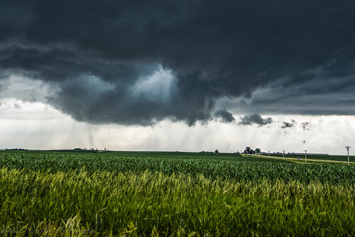
I arrived just east of Pella and stopped for some pictures of the hail core and inflow bands into the storm and then made my way to the east side of town. While driving those last few miles, suddenly a large bowl shaped lowering appeared and looked like a tornado was on the ground or imminent.
By the time I found a good place to stop and look to the west the "bigger" portion of the tornado from when it was on the ground, was basically done, but I did get a nice 5-7 minutes of the persistent funnel cloud.
I went east with the storm for a while before it pretty quickly weakened and I ended up in Oskaloosa to see the amazing cloud formations above.
I grabbed a bite to eat and headed back to Omaha. It ended up being a great Father's Day chase and my first tornado I've seen in Iowa in probably 5-6 years!