2020-05-25 Reports: AR/OK

Nate M.

EF0
Joined
May 16, 2019
Messages
30
Location
Neosho Mo
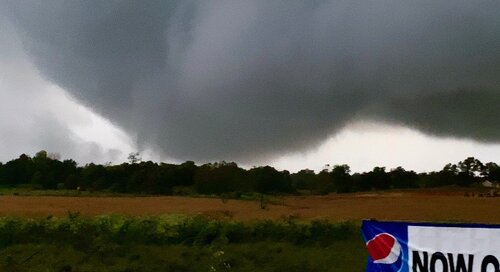
This is what I would call a bonus chase in my backyard, with a messy pattern of convection moving northwest out of western Arkansas into eastern Oklahoma. The upgrade to slight risk and tornado watch at the 20z outlook began to get our attention so we headed an hour south of home to Jay, Ok for a tornado play on a rogue supercell headed northwest, well ahead of the main line of storms. As we arrived, our storm got a tornado warning and the circulation really began to wrap up, although it was moving into awful chase territory. Road network in far northeast Oklahoma is curvy, hilly, and heavily wooded, but if you've lived here 35 years like I have you just learn to make the best of it. I knew we'd have a chance at a view in the flatter country southeast of Grove, Ok. By the time we got in position at flatter terrain we were too close for any grand structure shots, but did get some video of the tree hugger wall cloud and Ef0 tornado just southeast of Grove. Its a goofy feeling chase to follow these flip-flopped storms (hook on the northeast side of a western moving supercell) We followed the storm to near Wyandotte at dark when the trailing line of storms caught the lead supercell and ended the chance for a tornado. Tulsa NWS released their report yesterday, confirming our cell produced 3 weak tornadoes in very rural terrain with minimal damage. All in all it was a very fun, spontaneous 3 hour chase and really infected my brother with a love of chasing. We just went out with a couple of phones and an SUV. Here is a meager screen grab of the very low wall cloud and weak tornado southeast of Grove.
A12C33F2-F001-48BC-B939-1532620F4B34.jpeg
 
This is what I would call a bonus chase in my backyard, with a messy pattern of convection moving northwest out of western Arkansas into eastern Oklahoma. The upgrade to slight risk and tornado watch at the 20z outlook began to get our attention so we headed an hour south of home to Jay, Ok for a tornado play on a rogue supercell headed northwest, well ahead of the main line of storms. As we arrived, our storm got a tornado warning and the circulation really began to wrap up, although it was moving into awful chase territory. Road network in far northeast Oklahoma is curvy, hilly, and heavily wooded, but if you've lived here 35 years like I have you just learn to make the best of it. I knew we'd have a chance at a view in the flatter country southeast of Grove, Ok. By the time we got in position at flatter terrain we were too close for any grand structure shots, but did get some video of the tree hugger wall cloud and Ef0 tornado just southeast of Grove. Its a goofy feeling chase to follow these flip-flopped storms (hook on the northeast side of a western moving supercell) We followed the storm to near Wyandotte at dark when the trailing line of storms caught the lead supercell and ended the chance for a tornado. Tulsa NWS released their report yesterday, confirming our cell produced 3 weak tornadoes in very rural terrain with minimal damage. All in all it was a very fun, spontaneous 3 hour chase and really infected my brother with a love of chasing. We just went out with a couple of phones and an SUV. Here is a meager screen grab of the very low wall cloud and weak tornado southeast of Grove.
View attachment 20626

It was a fun little chase. I got the one (and reported it) near Watts.
 
Back
Top