2020-04-12 EVENT: TX/AR/LA/TN/KY/MS/AL/GA/FL

I’m getting word that a chaser in southern MS crossed a median and is driving on the wrong side of a highway to chase one of the violent tornadoes ongoing. I thought storm chasers were supposed to be “saving lives” and were deemed “essential.” This is pure stupidity. Putting additional lives at risk to chase a storm?

This is supposedly a screenshot from his Twitch live-stream.

View attachment 20290

Nick, are you referencing this twitter post?
 
There were cars coming in the opposite direction -- despite what someone else said. What if there was no way to cut back across the median to the correct side? I just don't understand the urgency to track a very fast moving, low visibility tornado? Then again, when you still have news outlets encouraging chasers to "do anything" to get on the air, and other idiots bragging about getting their vehicle destroyed, you don't have to look hard to find the encouragement to do ass clown stunts. Chase-related deaths are like an earthquake fault. The pressure was released several years ago, but now you can just feel the tension building until the next tragedy. It almost let go last year.
 
I didn’t start a reports thread for this event, because I couldn’t see anything. These tornadoes in Mississippi, even the discrete supercellular ones, were not visible unless you were within a mile and had a clear view.

I was chasing near Soso, close to where the chaser incident happened and I had no visual at all. Only for a brief time could I see the mesocyclone, but trees and very low LCLs were an issue.


Anyway, combine this with storms moving at close to highway speeds and you’re not really chasing. In hindsight, it would have been best to pick a spot and just intercept it, meaning watching it pass by. Knowing how large it was and all the trees, I didn’t dare get too close.

I encountered quite a bit of damage and saw one side of US-84 blocked by trees and debris for about a mile. I almost immediately called the chase off.

There’s no defense for this kind of behavior and to broadcast it live shows even more disregard. Not only are we going to drive dangerously, break traffic laws and put others in danger, but we’re going to show thousands of people in real-time that we have no problem doing it.
 
CNN a bit critical on damage ratings, with before and after imagery.


IMHO from some of the damage I have seen reported - I had a hard time not believing some of the damage reached EF-5 levels, with well constructed homes totally scraped from their foundations.

Awaiting the final results - widths remind me of Hallam, NE tornado from May 22nd, 2004.
 

Attachments

  • SRV_SosaTornado.png
    SRV_SosaTornado.png
    1.4 MB · Views: 0
  • SosaTornadoBV.png
    SosaTornadoBV.png
    492.9 KB · Views: 0
  • CollinsTornadoNROT.png
    CollinsTornadoNROT.png
    721.3 KB · Views: 0
CNN a bit critical on damage ratings, with before and after imagery.

Critical in what way? Maybe they edited but it just appears they are explaining how they are ranked.

IMHO from some of the damage I have seen reported - I had a hard time not believing some of the damage reached EF-5 levels, with well constructed homes totally scraped from their foundations.

A home "slab swept clean" starts at 165mph.
 
Couple of points here:

The big one is that the most recent official PNS from Jackson, which was released only last night, remains incomplete for the big tornado tracks. (National Weather Service Text Product Display ...probably not a permalink). That means things could change, including the final rating.

I am confident the NWS Jackson WFO will perform a sufficiently detailed damage survey. It is their job. And since the tornado was known to be significant at the time, a Quick Response Team was probably summoned and will help perform a more scrutinized-than-average survey. That is probably one reason (other than the amount of ground to cover given the length of the track) the survey is taking a long time.

The second big point to consider is that EF-scale rating is based on estimated wind speeds based on damage, and for each DI that is inspected, the DOD has a range of possible values that are dependent on quality of construction. In any rural areas, but especially those in the deep South, where money probably isn't great and things were built a long time ago, construction quality is likely to be pretty poor for most DIs. So even if a DI received the maximum DOD, poor construction quality would force the assessor to select the low end of the range of wind speeds to assign to that damage. It is not easy nor simple to distinguish between EF4 and EF5 damage in the modern era using traditional DIs like single family detached homes (a staple of the old Fujita scale). Provided you don't see something truly extreme, like craters or entire swaths of forest swept clean (not talking about a massive blowdown of trees, but the trunks carried away from their original location, too), you're not going to be able to declare EF5 damage from a broad, cursory examination of some damage from afar. You need to examine details like quality of construction, which takes a trained eye to spot.

Also keep in mind that many tornadoes probably end up being recorded as lesser rated than they could have been because of a dearth of DIs. If a tornado containing 300 mph winds goes through an open field and never impacts any robust structures directly, it will go down as something less than EF5, including EFU. So not every tornado even *has* the potential to be rated EF4/5 because there just aren't DIs to impact.
 
A person on the Discord server posted the following comments, just wondering what y'all's thinking on this is:

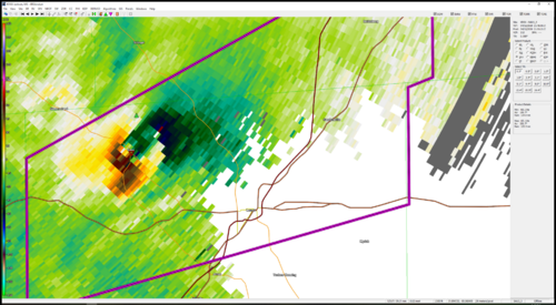
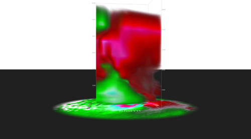
"For Easter Sunday, there's still just one burning question to me in which I'd love to hear opinions on. Despite this being a very massive tornado outbreak with more and more tornadoes being reported even still, the one part that did NOT make sense to me was Southern AL having very few tornadoes and a very mitigated threat while being surrounded with strong tornadoes. S AL had a lot of surface heating in the warm sector after the midday mess of storms went through, and if North-Central AL and S GA didn't have these problems with reheating, It doesn't make sense that S AL would've had them. When the two strong supercells that put down the Bassfield tornado family first came out of the elevated LA convection, it was assumed that these supercells would continue to track deep through AL in a very healthy warm sector. The first cell, however, inexplicably died as it got close to the MS/AL border. The cell, when it died, accelerated and turned VERY hard left, going almost due north up the state line. The second, trail cell that also was producing tornadoes did almost the exact same thing at the exact same location. The third supercell in the line, which never quite produced tornadoes iirc but was a healthy looking supercell that looked to become dominant, also behaved very similarly, and again in almost the exact same location. The HRRR nailed the development of the first two supercells, but did not anticipate their death. The burning question for me is: why did these supercells die in what looked to be an extremely healthy environment? Does the rapid left turn indicate capping problems and them becoming elevated as they got to the border, perhaps because the cap hadn't eroded enough? Or is there something else at play here?(edited)

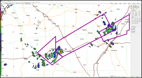
In addition, new elevated development in the LA panhandle, further south than the 2x EF-4 family that started just west of the same location, was fully expected to become supercellular with time as they went more surface based in SE MS. This Cellular development, however, never quite went surface based, and it appeared to form into a messy squall before it could become fully surface based. This squall didn't become organized in a QLCS mode until it reached Georgia, with S AL getting a grungy, messy squall that produced nothing but severe winds. As soon as this squall got past AL, it became more QLCS in nature and produced numerous tornadoes, including eventually leading to the stronger ones that impacted Southern SC at about 11Z (two of which got EF-3 ratings, iirc). I've heard a few theories about why this has taken place, but I'd like to get more opinions from people who know more about this event than I do. The theories I've heard thus far: 1) Surface heating wasn't as great in AL, and the cap was still in place; as a result only more linear storm modes were sustainable in that area 2) Winds veered unexpectedly early, killing surface convergence in S AL. Even if this was the case, why'd the storms suddenly become more tornadic once they reached GA? The shear profiles in AL were still off the charts during the event. 3) The elevated convection in the LA panhandle was growing upscale before it could become surface based, and by that time needed way more time to organize and mature before being able to produce tornadoes. I would favor this theory being that it most closely resembles what I saw on radar during the event, but it doesn't explain the abrupt death of the first supercell family. 4) The shear in S AL was so great that it tore apart the updrafts of any supercells in the area. This could make sense, but wouldn't deeply established supercells be able to harness that energy anyways?

I'm hoping that some of you have more answers than I do. It's certainly an interesting case study given the ridiculous parameters in place in S AL during the event."
 
Back
Top