Jesse Risley
Staff member
Since this event is finally coming into range of the NAM, it's time to start a thread highlighting the possibility of a substantial severe weather threat for much of Dixieland on Easter Sunday. The GFS has heretofore been more progressive than the ECMWF, so something akin to a blend between the ECMWF and the NAM will probably be a more reasonable solution.
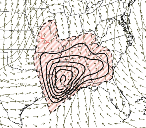
Models have been depicting a closed low, associated with the southern stream of a broader longwave pattern of energy traversing over the CONUS, kicking out of the Baja region this weekend, with the stout southern shortwave moving out of the southern Plains and taking on a more negative tilt as it pushes into the mid-Mississippi River valley. A surface cyclone should move out of the eastern Red River valley and deepen as it moves towards W TN and then the Ohio River valley by early Sunday evening. The northward extent of the warm sector is still somewhat in question, which will help determine the exact region of optimal instability, but strong deep layer shear should be juxtaposed with ample warm sector instability - owed partially to rich Gulf moisture - across the eastern fringes of the Western Gulf Coastal Plains, the Lower Mississippi Alluvial Valley, and the Eastern Gulf Coastal Plains region, perhaps even moving well north of I-20 by Saturday evening.
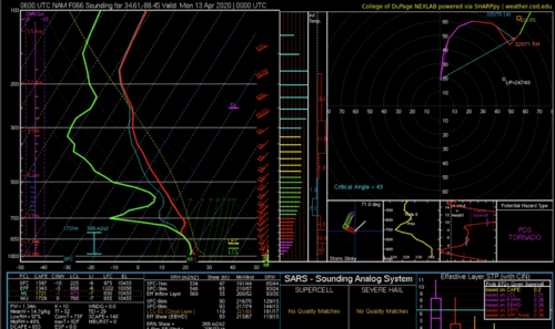
Forecast deep layer vertical share profiles, owed partially to strong and increasingly favorable H85 wind profiles, certainly favor discrete supercells, with substantial 0-1 km SRH, favorable LCLs and plenteous instability yielding the possibility of some significant tornadoes, particularly if storms remain discrete, though all modes of severe weather are possible. Early day EML should help to suppress convection in the warm sector until convection redevelops INVO a surface trough that will likely incite the primary, deep convective activity that has the potential to be the most volatile. With otherwise favorable deep layer vertical shear and ample speed shear in place, the real factor to monitor will be the size and northward extent of the warm sector and how any ancillary convection otherwise associated with this dynamic system impacts that, as well as the final placement of the warm front and the most favorable Theta-e axis. Some of the forecast soundings indicate the potential for tornadic activity to continue eastward well after dark. Timing and placement of certain synoptic features are likely to vacillate between now and Sunday afternoon as RAOB systems better sample the energy currently out west.
Models have been depicting a closed low, associated with the southern stream of a broader longwave pattern of energy traversing over the CONUS, kicking out of the Baja region this weekend, with the stout southern shortwave moving out of the southern Plains and taking on a more negative tilt as it pushes into the mid-Mississippi River valley. A surface cyclone should move out of the eastern Red River valley and deepen as it moves towards W TN and then the Ohio River valley by early Sunday evening. The northward extent of the warm sector is still somewhat in question, which will help determine the exact region of optimal instability, but strong deep layer shear should be juxtaposed with ample warm sector instability - owed partially to rich Gulf moisture - across the eastern fringes of the Western Gulf Coastal Plains, the Lower Mississippi Alluvial Valley, and the Eastern Gulf Coastal Plains region, perhaps even moving well north of I-20 by Saturday evening.
Forecast deep layer vertical share profiles, owed partially to strong and increasingly favorable H85 wind profiles, certainly favor discrete supercells, with substantial 0-1 km SRH, favorable LCLs and plenteous instability yielding the possibility of some significant tornadoes, particularly if storms remain discrete, though all modes of severe weather are possible. Early day EML should help to suppress convection in the warm sector until convection redevelops INVO a surface trough that will likely incite the primary, deep convective activity that has the potential to be the most volatile. With otherwise favorable deep layer vertical shear and ample speed shear in place, the real factor to monitor will be the size and northward extent of the warm sector and how any ancillary convection otherwise associated with this dynamic system impacts that, as well as the final placement of the warm front and the most favorable Theta-e axis. Some of the forecast soundings indicate the potential for tornadic activity to continue eastward well after dark. Timing and placement of certain synoptic features are likely to vacillate between now and Sunday afternoon as RAOB systems better sample the energy currently out west.
Last edited: