Quincy Vagell
EF4
I started the day with a target of northeastern Arkansas. I did not feel it was worth it to go up into Illinois for a variety of reasons. The southern play would have a more conditional threat, but a better environment to work with.
By the time I got to Searcy, AR, I decided to head northeast toward southeastern Missouri, as an increasingly agitated cumulus field caught my eye. A few semi-discrete storms developed in the area, but the storms were struggling to organize. As this was happening, a storm developed over far northern Arkansas, near the central part of the AR/MO border. At first, I had doubts about this storm maintaining itself, but as it moved ESE and split, the right split was beginning to tap into the northwestern fringe of a plume of rich boundary layer moisture.
Even though larger low-level CAPE was tugging part of me to hang with the southeastern Missouri storms, I could not help but favor a more discrete storm that would eventually move into an area with dew-points near 70F and stronger near-surface winds. The low-level moisture field farther north was a bit fragmented, with dews generally in the low to mid-60s. It was also going to make the drive back after the storm chase several hours shorter.
I finally broke away and circled around back into Arkansas. Even though it would take about 90 minutes to finally catch up to the storm, it would be moving toward me and pushing off from the hilly, forest area, into the more chaser-friendly part of northeastern Arkansas.
As I looped around and got out of the direct path of the sun, a well-organized supercell could be seen near Swifton. In terms of storm structure, this was probably one of my best storms in Arkansas to-date. I wanted to keep back just far enough to see the structure, but with sunset approaching, the low-level jet strengthening and signs of better organization on radar, it was time to get a closer look. Placement was lucky in terms of chaser-friendly terrain, as if the storm had been just 15-20 miles farther west, it would have been much harder to see.
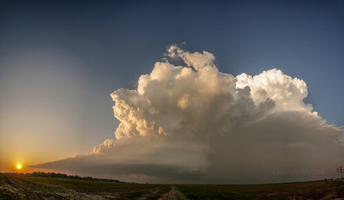
The two options would be to drop south into Grubbs and then turn back around to the northeast toward Cash, or head east directly into Cash. The latter option would be close to core punching and I generally favor a route with a better view of the storm. The only issue was that once in the Grubbs area, there is no reliable road east, as there's a wildlife area filled with marshes and trees. With daylight fading, it was time to dart south into Grubbs.
I turned northeast on AR-18 from Grubbs and had a visual on a low hanging, grungy wall cloud. This beefy structure led me to believe there was a relatively high probability of this storm producing a tornado, imminently. I stopped just south of Cash, as I was close to the storm and there was a funnel cloud lowering.
I went about one block east on a dirt road before it came to an end. It ended up being a good place to stop, as the storm went on to produce about a 2-3 minute tornado just moments after I stopped. The time was around 7:50 p.m., so it was after sunset and light was fading. I started an Instagram live broadcast as the tornado was forming and that footage would have been good if the resolution was better, but it will do:
Most of the footage I got is a bit on the grainy side, due to poor lighting and a lot of blowing dust. I've only seen a few tornadoes in Arkansas, but this was the most photogenic by far, even if I wasn't able to get the clearest footage. Either way, I'd say it's probably the best tornado chase I've had since at least 2017 and possibly 2016, considering how close I was able to get.
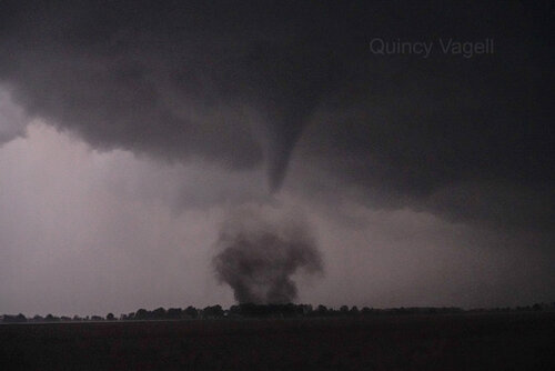
Once the tornado appeared to dissipate, I decided to bail and get ready for the long drive ahead. The storm did produce another tornado a short time later, to the south of Jonesboro, but I did not see the second tornado.
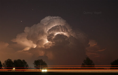
I did not get far before I saw the distant supercell lit up in the night sky to the east. I stopped for a few more photos before, once and for all, calling the chase off.
By the time I got to Searcy, AR, I decided to head northeast toward southeastern Missouri, as an increasingly agitated cumulus field caught my eye. A few semi-discrete storms developed in the area, but the storms were struggling to organize. As this was happening, a storm developed over far northern Arkansas, near the central part of the AR/MO border. At first, I had doubts about this storm maintaining itself, but as it moved ESE and split, the right split was beginning to tap into the northwestern fringe of a plume of rich boundary layer moisture.
Even though larger low-level CAPE was tugging part of me to hang with the southeastern Missouri storms, I could not help but favor a more discrete storm that would eventually move into an area with dew-points near 70F and stronger near-surface winds. The low-level moisture field farther north was a bit fragmented, with dews generally in the low to mid-60s. It was also going to make the drive back after the storm chase several hours shorter.
I finally broke away and circled around back into Arkansas. Even though it would take about 90 minutes to finally catch up to the storm, it would be moving toward me and pushing off from the hilly, forest area, into the more chaser-friendly part of northeastern Arkansas.
As I looped around and got out of the direct path of the sun, a well-organized supercell could be seen near Swifton. In terms of storm structure, this was probably one of my best storms in Arkansas to-date. I wanted to keep back just far enough to see the structure, but with sunset approaching, the low-level jet strengthening and signs of better organization on radar, it was time to get a closer look. Placement was lucky in terms of chaser-friendly terrain, as if the storm had been just 15-20 miles farther west, it would have been much harder to see.

The two options would be to drop south into Grubbs and then turn back around to the northeast toward Cash, or head east directly into Cash. The latter option would be close to core punching and I generally favor a route with a better view of the storm. The only issue was that once in the Grubbs area, there is no reliable road east, as there's a wildlife area filled with marshes and trees. With daylight fading, it was time to dart south into Grubbs.
I turned northeast on AR-18 from Grubbs and had a visual on a low hanging, grungy wall cloud. This beefy structure led me to believe there was a relatively high probability of this storm producing a tornado, imminently. I stopped just south of Cash, as I was close to the storm and there was a funnel cloud lowering.
I went about one block east on a dirt road before it came to an end. It ended up being a good place to stop, as the storm went on to produce about a 2-3 minute tornado just moments after I stopped. The time was around 7:50 p.m., so it was after sunset and light was fading. I started an Instagram live broadcast as the tornado was forming and that footage would have been good if the resolution was better, but it will do:
Most of the footage I got is a bit on the grainy side, due to poor lighting and a lot of blowing dust. I've only seen a few tornadoes in Arkansas, but this was the most photogenic by far, even if I wasn't able to get the clearest footage. Either way, I'd say it's probably the best tornado chase I've had since at least 2017 and possibly 2016, considering how close I was able to get.

Once the tornado appeared to dissipate, I decided to bail and get ready for the long drive ahead. The storm did produce another tornado a short time later, to the south of Jonesboro, but I did not see the second tornado.
I did not get far before I saw the distant supercell lit up in the night sky to the east. I stopped for a few more photos before, once and for all, calling the chase off.


