Quincy Vagell
EF4
I targeted Southwest Texas yesterday for what appeared like a localized setup for a few supercells.
I initially started in Fort Stockton, but ended up adjusting location a few times. For starters, a rogue storm started developing southeast of Fort Stockton, so I went in that direction. That storm seemed to plateau and the environment was more favorable for tornadoes farther west. Once a couple of storms developed northwest of Marfa, I re-positioned in that direction. It was not long before the supercell southeast of Fort Stockton really started to intensify. I realized that the downstream environment was highly supportive for a long-lived supercell, so I once again went back in that direction.
This storm was producing very large, if not giant hail, for quite some time. I knew that I had to keep this in mind as I approached. The road network was not very favorable, so I had to drive about an hour east and then drop south to get a visual on the storm. I wanted to go south between Sheffield and Ozona, but by the time I reached the exit. I realized this was not going to be a smart move. With how invested I was on this storm, which was at least 2-3 hours away from my original target, I had to be sure that I could safely get in front of the storm and have some photo opportunities.
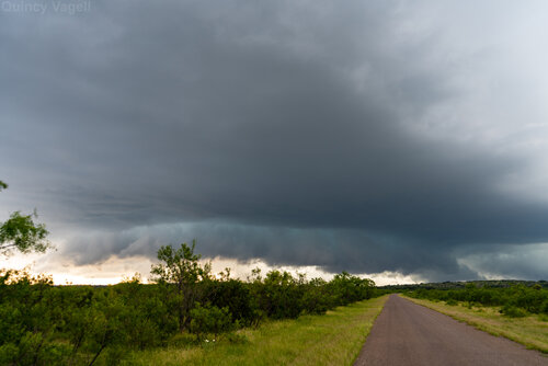
I finally got out in front of the storm, just as it became tornado-warned. I dropped south from Ozona and had a visual on the intense supercell to the west. While it was not the most impressive structure of the year, it was one of my personal best storms. No smoke, very few chasers around and a storm with noteworthy structure that was most likely going to last for a while longer. There was a bit of a wall cloud, but low-level rotation was fairly modest. It almost looked like this storm might be ever-so-slightly elevated as well. I understand the tornado warning, due to an impressive radar signature, but keep in mind that this storm was toward the outer edges of both SJT and FDX radar beams. Neither could get a really good scan.

I took a few photos before this, when the structure was arguably the most impressive, but there was so much lightning that it was hard to get a good panoramic photo. This, plus the lightning strikes were so frequent and random that I did not want to risk getting struck. Within a minute of trying, I immediately got back in the car.
I went east-southeast to follow the storm, but I soon lost all internet access and radar data for roughly the next three hours. Even my weather radio struggled to get any radio stations. I was moving into an area that was only about 50 miles from the Mexico border (south of I-10) and across hilly/somewhat forested terrain around Edwards Plateau. It was some of a surreal area to be chasing, as I would drive and see very few vehicles or houses for the next couple of hours, aside from occasional ranches.

Unfortunately, due largely to terrain and an odd amount of power lines (which were on both sides of the road for a lot of this chase), I did not capture a lot of photos or video. I was able to get a few breaks here and there. The road I was on, TX-55, was the only paved road in the area and due to the storm's trajectory, I literally had to stay in front of it. There was no possible exit strategy. Based on the few stray radar images I did grab, there was no going back northwest through this storm until it passed.
I made it all the way down to Rocksprings before it was clear the storm was collapsing and I could get back on track. I actually toyed with the idea of looking for a hotel in Del Rio, but the options were limited/expensive and it wasn't exactly in the best spot to start for storm chasing today, the 31st.
On the way back north, I encountered quite a bit of hail on TX-55 in far northern Edwards County. After speaking with a meteorologist who was warning this storm, he was fairly certain that hail could have been 3" in diameter at times. The hail I saw had been on the ground and road surface for at least 90 minutes and possibly two hours. At that time, it was still several inches deep and I saw a few hailstones as large as 1.75".
Overall, it was very neat to have my first storm chase south of I-10 and actually have a photogenic storm to work with. The lack of data was tough, however, especially when combined with poor visibility due to terrain. I'm not sure how likely I would be to chase in that area again, but at least if I do, I have a good idea of what to expect.
I initially started in Fort Stockton, but ended up adjusting location a few times. For starters, a rogue storm started developing southeast of Fort Stockton, so I went in that direction. That storm seemed to plateau and the environment was more favorable for tornadoes farther west. Once a couple of storms developed northwest of Marfa, I re-positioned in that direction. It was not long before the supercell southeast of Fort Stockton really started to intensify. I realized that the downstream environment was highly supportive for a long-lived supercell, so I once again went back in that direction.
This storm was producing very large, if not giant hail, for quite some time. I knew that I had to keep this in mind as I approached. The road network was not very favorable, so I had to drive about an hour east and then drop south to get a visual on the storm. I wanted to go south between Sheffield and Ozona, but by the time I reached the exit. I realized this was not going to be a smart move. With how invested I was on this storm, which was at least 2-3 hours away from my original target, I had to be sure that I could safely get in front of the storm and have some photo opportunities.
I finally got out in front of the storm, just as it became tornado-warned. I dropped south from Ozona and had a visual on the intense supercell to the west. While it was not the most impressive structure of the year, it was one of my personal best storms. No smoke, very few chasers around and a storm with noteworthy structure that was most likely going to last for a while longer. There was a bit of a wall cloud, but low-level rotation was fairly modest. It almost looked like this storm might be ever-so-slightly elevated as well. I understand the tornado warning, due to an impressive radar signature, but keep in mind that this storm was toward the outer edges of both SJT and FDX radar beams. Neither could get a really good scan.

I took a few photos before this, when the structure was arguably the most impressive, but there was so much lightning that it was hard to get a good panoramic photo. This, plus the lightning strikes were so frequent and random that I did not want to risk getting struck. Within a minute of trying, I immediately got back in the car.
I went east-southeast to follow the storm, but I soon lost all internet access and radar data for roughly the next three hours. Even my weather radio struggled to get any radio stations. I was moving into an area that was only about 50 miles from the Mexico border (south of I-10) and across hilly/somewhat forested terrain around Edwards Plateau. It was some of a surreal area to be chasing, as I would drive and see very few vehicles or houses for the next couple of hours, aside from occasional ranches.

Unfortunately, due largely to terrain and an odd amount of power lines (which were on both sides of the road for a lot of this chase), I did not capture a lot of photos or video. I was able to get a few breaks here and there. The road I was on, TX-55, was the only paved road in the area and due to the storm's trajectory, I literally had to stay in front of it. There was no possible exit strategy. Based on the few stray radar images I did grab, there was no going back northwest through this storm until it passed.
I made it all the way down to Rocksprings before it was clear the storm was collapsing and I could get back on track. I actually toyed with the idea of looking for a hotel in Del Rio, but the options were limited/expensive and it wasn't exactly in the best spot to start for storm chasing today, the 31st.
On the way back north, I encountered quite a bit of hail on TX-55 in far northern Edwards County. After speaking with a meteorologist who was warning this storm, he was fairly certain that hail could have been 3" in diameter at times. The hail I saw had been on the ground and road surface for at least 90 minutes and possibly two hours. At that time, it was still several inches deep and I saw a few hailstones as large as 1.75".
Overall, it was very neat to have my first storm chase south of I-10 and actually have a photogenic storm to work with. The lack of data was tough, however, especially when combined with poor visibility due to terrain. I'm not sure how likely I would be to chase in that area again, but at least if I do, I have a good idea of what to expect.
Last edited:
