2019-05-17 REPORTS: TX/KS/NE/OK

Frustrating day, despite seeing a tornado. After several days of going back and forth on where to target, the consistency of models showing nothing happening along the dryline in the southern sector led to the decision to head north. Drive all day Thursday and ended up in North Platte, Neb. The thinking there was that from there we would have the option to target either the warm fron play which would be east of us or the northern dryline play with the advantage there that storms would be headed towards us. Woke up Friday morning and made the decision to go south to McCook. My one big point for the day was to not end up behind fast moving storms trying to catch up from behind them to the south. Sat in the parking lot of the McCook WalMart for about three hours before deciding with Bill Hark to head south toward Oberlin to try and intercept a storm that had formed. Went from Oberlin over to Atwood and sat there watching the storm for a while. Then headed back east and that's where we made the mistake. Instead of heading north on the 117 behind the storm, we went all the way back over to Oberline before heading north because we were afraid of getting cut off by the storm if we went north at 117. A valid concern, and a decision made with logical reasoning. But a wrong decision nevertheless. And just like that we were in the one situation I had vowed not to be in, behind the storm trying to play catch-up. We did catch a glimpse of the McCook tornado off to our west as we headed back to town. Wasted more time getting thru McCook and then almost gave up for the day before deciding to go a little further north, having seen that the storm had slowed down. Could get the idea that there was something going on in the murk as we near Farnam but never actually saw the tornado. Had to detour around Farnam because of the downed power lines east of time - chased it almost to the interstate before gas and light became issues. Got gas at I-80 and then went to Colby Kansas for the night. Hate to think what we could've seen had we just stayed in that Walmart parking lot in McCook. A+ for stagi Sometimes on-the-fly choices that have valid reasoning turn out to be wrong decisions.

First pic is from just west of Atwood
 

Attachments

  • IMG_1064.JPG
    IMG_1064.JPG
    165.3 KB · Views: 0
  • IMG_1069.JPG
    IMG_1069.JPG
    120.1 KB · Views: 0
  • IMG_1071.JPG
    IMG_1071.JPG
    105.3 KB · Views: 0
Good day all, Here is my report for storms for May 17, 2019...

Chase Summary: May 17 was a very complex chase day that was frustrating at first but ended up being a pretty good day, with at least 3 beautiful tornadoes observed in Frontier County, Nebraska. I woke up and did my forecasting and objective for the day. The SPC had an enhanced risk in two areas most of the day, with one in SW Texas, and the other in SW Nebraska and extreme NW Kansas. The latter was my target area I was looking at the past few days. Tornado probabilities were 10%, with hail and wind both hatched (for significant) at 30%. The Texas outlook was for a 5% tornado probability. A conditional threat connected these two areas with strong capping from W Texas into SW Kansas. A surface low was moving out of NE Colorado, with an upper Pacific trough providing the support for severe weather. A stationary frontal boundary intersected this surface low, and a dryline extended south from there near SW Nebraska. This was a very challenging forecast, with two "sub targets" in this northern risk area (the "triple point" OR the dryline "bulge" about 100 miles to the south). I left North Platte and waited in Ogallala. Mesoscale discussion 649 and subsequent tornado watch box 172 (valid until 10 PM CDT) were also issued by the SPC. An extremely complex convective scenario unfolded - With an isolated supercell over NE Colorado, smaller supercells near the triple point over SW Nebraska, and more storms over NW Kansas ahead of the dryline. I headed south via SR 61 to Grant, then east on SR 23 to near Highway 83. Initiation was confusing and I headed towards a storm near Grant, then eventually north to I-80, then back east to North Platte. Realizing the best chance of seeing tornadoes was a storm near McCook, I hastily headed south on Highway 83 to catch up with the cyclic "tail end Charley" storm near Curtis via SR 23 and 18. Tornadoes were finally encountered in Frontier County with damage east of Farnam. I continued east and north on SR 21 through Cozad to I-80 east to SR 21 north to observe the storm evolution. By dusk (around 9 PM) I left the storm, heading southeast on SR 40 and into Kearney for the night.

Storm Interception Details Are Below

1). May 17, 5:00 PM
- Interception and observation of a severe thunderstorm north of Grant, Nebraska in Perkins County north of SR 23 and south of I-80. The storm was a supercell storm that developed ahead of a triple point / convergence area. This storm did not last long as it continued north of I-80 and down-scaled / merged with a line of storms. The core of this storm was not penetrated, and a small wall cloud was observed with the storm at peak intensity. The core had golfball sized hail or larger. Strong inflow winds of 45 MPH and lightning was encountered east of this storm. Conditions causing this storm were surface heating, a low pressure area, frontal boundary / dryline interactions, and an upper trough. Documentation was digital stills and HD video. A 2016 Jeep Wrangler was used to chase the storm. A tornado watch was also valid for the area until 9 PM MDT.

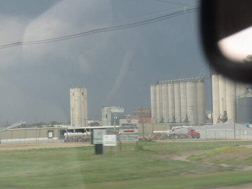
2). May 17, 6:30 PM - Interception and penetration of an extremely severe and tornadic thunderstorm in Frontier County, Nebraska from near SR 18 and 23, near Curtis and Farnam, and northeastward across I-80 to near Gotenburg and Highway 47. The storm was a cyclic supercell storm. Mainly classic mode from near McCook to Farnam, and HP like afterwards. The storm was penetrated as it was between cycles near Curtis and hail up to 1" was encountered with heavy rains, frequent lightning with close hits, and 60 MPH winds. At least 3 tornadoes were encountered with this storm, two of which highly visible and below a supercell with an impressive structure. Powerful RFD was encountered near Farnam, with gusts near 75 MPH and hail up to 2" as the tornado became rain wrapped. Damage was observed east of Farnam with downed powerlines, trees down, and some damage to outbuildings. The storm continued northeast past I-80 and continued to produce tornadoes until 8:30 PM, but these were less visible, before evolving to a line segment over the Nebraska sand-hills. Conditions causing the storm were surface heating, a dryline, low pressure system, and upper trough. Documentation was digital stills and HD video. A 2016 Jeep Wrangler was used to chase the storm. A tornado watch was also valid for the area until 10 PM CDT.

Pictures For May 17, 2019 Are Below

m20sat2.jpg

Above: his is an annotated visible satellite image at roughly 23z showing the storms and environment unfolding over SW Nebraska and NW Kansas on May 17, 2019. Note the main supercell of interest at the southern most area in the convective activity, which is also the same cyclic supercell that affected areas from McCook, Nebraska and northward on May 19.

m20rad4.jpg

Above: This is an image showing the impressive supercell storm and hook echo on the base reflectivity as it was northeast of McCook, Nebraska and approaching Farnam on May 17. The inset is the Doppler Velocity. The radar site is from North Platte and may not reflect the low level details of the storm as the beam was transecting the storm at or above 10,000 feet MSL.

m20tor5.jpg

Above: Ground circulation and dust / debris cloud confirms a tornado near Stockville and southwest of Farnam, Nebraska near 7 PM CDT on May 17.

m20tor7.jpg

Above: Large multi-vortex and dusty tornado, confirmed by expansive dust under rapidly rotating wall cloud, to the southwest of Farnam, Nebraska at about 7:15 PM CDT on May 17.

m20tor6.jpg

Above: 
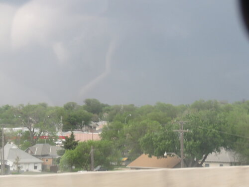
Beautiful elephant trunk tornado as of 7:30 PM to the southwest of Farnam, Nebraska on May 17. Image is slightly enhanced to reveal the details.

m20tor8.jpg

Above: Close up view of the elephant trunk / stovepipe tornado southwest of Farnam, Nebraska on May 17.

m20p3.jpg

Above: Hurricane Hunters WP-3 "Orion" aircraft circling overhead and east of the tornadic supercell on May 17 near Farnam. This is a research project known as TORUS (Targeted Observations by Radars and UAS of Supercells) going on in 2019.

m20tor11.jpg

Above: This is a view looking east of Farnam, Nebraska with the tornado lifting to the left, and the road way up ahead blocked by powerlines. Note the powerful RFD clear slot and dust being kicked up below it! This was about 7:45 PM CDT on May 17.

Note: For DETAILS on this storm / setup as well as others in May 2019 … Please visit the link BELOW for more information!

http://www.sky-chaser.com/mwcl2019.htm#EXP19
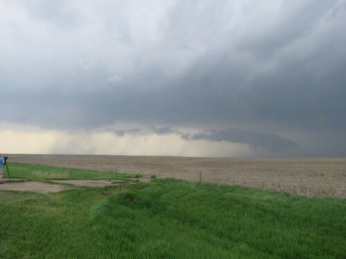
 
Started the day in Stuart, IA and left my hotel mid morning with a target of McCook, NE of all places. Stopped at the Lexington, NE exit off I80 to evaluate things. Decided to keep heading for McCook, but on the way there, storms started forming nearby. I knew wind shear was excellent thanks to the warm front nearby, but I questioned the quality of the thermos. This proved to be a wise thought, as I followed the storms for a bit, but eventually let them go as it was clear the low level instability was still lacking, as the storm bases seemed anemic and stable. At that time I noticed a beefy cell had initiated near Goodland, KS and the thermodynamic environment also looked better to my SW, so I again plotted a course for McCook. I finally arrived in McCook after negotiating two rather lengthy and annoying one lane road/pilot car road construction zones on US34. Things were really looking good at this point though, as the Goodland cell was slowly intensifying and heading my way. I stopped for gas and food in McCook, and then headed just a bit SW to get a view and let the storm come to me. The cell took a bit to really get it's act together, but eventually became a cyclic beast just west of town. Followed it till just before dark, and witnessed multiple tornadoes of different shapes and sizes. A great way to start an extended trip to the plains!!!
onILQK3.jpg


bGTwoWS.jpg


1dZXbzs.jpg


aL29zoA.jpg


WUT0LZQ.jpg
 
After reluctantly throwing in the towel on my original target (Southwest Kansas) my chase partner Dakota Maynard and I decided to swing for the fences and head northwest towards Colby, KS.

We left late and we knew we wouldn't make it in time before initiation, but we wanted to catch whatever supercell that did form in its infancy. We did not count on there being road construction on I-70 west of WaKeeney which had reduced the interstate to one lane and slowing us down in the process. Our original plan was to get to Oakley and head north on US-83, but we were forced to take K-23 instead through Hoxie before jumping on US-83.

By the time we made it to McCook, NE the first tornado was already in progress.mccook copy.jpgmccook2 copy.jpg
From our angle the contrast was poor and I had a hard time seeing the debris cloud. After the McCook tornado roped out we headed east on US-34 towards Indianola and then north on a dirt road pretty much stair stepping the storm.

We saw our second tornado of the day on highway 18 east of Stockville.stockville copy.jpg
It lasted a few minutes before dissipating.

A few minutes later our third tornado of the day the Farnam tornado touched down. I was able to get video of the early stage of the Farnam tornado before losing visual on it due to the hazy contrast and dust being whipped up by every other chaser on the dirt road we were on.

As we continued northward on the dirt road we were on I began to see the tornado again along with at least one other funnel cloud that spun up from the wall cloud. The tornado at this point was a dusty column with a funnel attached to it. As we got closer the funnel began to condense fully to the ground.farnam copy.jpgne art copy.jpg843.jpeg685.jpegIMG_20190517_191055934_wm.jpg
We tried to stay with the storm in hopes of catching the next tornado in Cozad, but our chase ultimately came to an end in Farnam when downed power lines prevented us from following the supercell any further.

This day goes down as my second best chase day behind Rozel. I chased Nebraska only one other time prior to this day which makes it even more special considering how restricted I am on chasing the Central and Northern Plains.

I do have video from this day on my YouTube channel if anyone wants to check it out.
 
I don't have much to add to Robert Balogh's report earlier in this thread. This was my first day out for the season, and I was still quite sick from a bad throat infection. I met up with Robert and John Mann were already in my target area of McCook, Nebraska after a long drive from Wichita. Instead of waiting in McCook for a storm to the south to reach us, we decided to drop south to intercept it near Oberlin and then Atwood. It started rotating very nicely, but was quickly moving north. Due to limited road options and concern that the storm would block a safe route northward, we decided to go east and then north rather than directly north on 117. We got a poor view of the tornado from south of McCook. By the time we crossed the town, it had dissipated. After having heard about serious road construction on 34 east of McCook, we initially gave up on the storm before attempting an intercept by going north on 83 and east on 23 through Curtis. I was a few miles east of Moorefield at 7:51 CDT when I got a glimpse of the Cozad tornado from a significant distance. The chase was over due to power lines blocking the road and I didn't want to attempt the detour on a muddy dirt road. Robert and John continued a bit farther to I-80. Congratulations to those who had good intercepts that day. I take the blame for the decisions that resulted in a less than optimal chase day though at the time, the reasoning was good and similar decisions on different chase days produced good results.

Low contrast distant view (video still) of the McCook tornado. I am south of McCook looking northwest across the town.

18795

Going east on 23, a few miles east of Moorefield. The view is to the northeast at 7:51 CDT of the Cozad, NE tornado.

18796
 
Debated the entire day before about whether or not to head up to north KS/ south NE. I was highly confident in tornadoes up there, but had concerns about it being a bit more messy and challenging. Down south, I was confident models were underdoing convection. There was a clear n-s oriented, sharp dryline with a fairly deep circulation and a slight bulge centered over the far northern OK panhandle into far southern KS. The environment would very clearly support isolated supercells and tornadoes if a storm could successfully sustain.

Sat most of the day in Beaver, OK watching towers struggle, until eventually one grew into a storm.

18967

The storm took on supercellular characteristics extremely quickly and a rotating wallcloud developed within a few minutes.

18968

We moved north to get a bit closer, and while positioning the funnel began to condense.

18969

We stopped to watch the show unfold. An amazing tornado ended up on the ground for a little under 20 minutes.

18970

18971

These days, I usually attempt to play tornadoes much closer than this, but as the tornado slowly moved nne away from us, I saw the opportunity to get shots I have always wanted : a beautiful tornado with the full supercell updraft above it. I took the opportunity.

18972

18973

The above shot is probably the best shot I have ever taken, no immediate obstructions or powerlines or anything of the sort, just an awesome storm and tornado.

After getting that shot, we planned to get closer but noticed that the tornado was about to rope out, so we stayed to watch.

18974

Afterwards, the tornado dissipated and we began to follow the storm to the north. Unfortunately, I was having extreme acid reflux issues and opted to bail and miss the subsequent tornadoes the storm produced. Oh well.
 
I started the day in Trinidad, CO and had 3 targets (s Nebraska, sw Kansas, e Texas panhandle) within reach. I was particularly torn between the dryline in the Oklahoma panhandle into southwest Kansas, and east of the surface low in southern Nebraska. Because I was running a week long tour, I decided to go with the safest play and targeted the surface low. We arrived in Goodland around 2pm as turkey towers were developing along the dryline to our south. I positioned us near Bird City, KS and intercepted a developing supercell north of Atwood, KS. We witnessed the entire life cycle of the Culbertson/McCook tornado. After the first tornado, I navigated north on HWY 83 to Maywood, NE, then east on HWY 23 to near Farnam, NE. We were positioned in the inflow notch on the foward flank. We watched the large dusty bowl tornado southwest of Farnam from a distance of a few miles, but were able to get an unobstructed view of the third tornado from about a mile away.

After these two cycles I navigated us north on HWY 47 up to Gothenburg, then east to north of Cozad. The supercell produced 3 more tornadoes, a brief spinup 4 miles northeast of Farnam, a large dusty bowl tornado north of Cazad, and a final weak tornado east of Cozad. This would be my favorite/best chase of spring 2019. That evening we were treated to quite a lightning show in Kansas as we made our way to Dodge City for the night.

PSX_20190525_212719[1].jpg
Mature Stage-Culbertson/McCook tornado

PSX_20190517_174133[1].jpg
Rope Stage-Culbertson/McCook, NE tornado 5.17.19

18985
Large dusty tornado and parent supercell updraft-sw Farnam, NE 5.17.19

18986
Dusty cone tornado-southwest of Farnam, NE 5.17.19

18987
Elephant trunk tornado and inflow tail-southwest of Farnam, NE 5.17.19

18988
Video still-dusty cone tornado-north of Cozad, NE 5.17.19
 
Started May16th in Greenville, South Carolina drove 17 1/2 hrs. To Foss, OK. Based myself at the State Park. May 17th decided to play in the TX/OK panhandle with the dryline play. It paid off well! The first Tornado dropped in Forgan, OK. Then later on we had the Minneola, KS tornado. Very good Chaser trip, our first Panhandle tornado!

Forgan, OK Video

18998

Minneola, KS Video

18999
 
I woke up in my bed in Amarillo this day, split with a 70% chance on going to SW NE, and 30% chance on chancing the Ft. Stockton area. It was the difference between an 8 hour drive north, or 5 hours south. To me, I don't think I've seen the south target look as good for tornadoes as I did on this day. And since I've never successfully chased the Trans-Pecos Valley, I decided to give it a shot. Sat in Midland for about an hour until the storm fired west of Ft. Stockton. We bolted southwest and arrived on the storm just as it started to ramp up. I was surprised at how high based and unorganized the "wall cloud" looked. But the rotation was looking good when a conical funnel came about 1/3 of the way down and began kicking up dust. As soon as the tornado was in progress, the big hail started falling. With it being the first chase of a 2 week stint, I didn't want to lose the windshield quite yet. So we blasted east a little to prevent losing glass. The structure after the tornado was some of the best of the year.

In addition to this chase, we spent the night in San Angelo, TX. We were awakened by our phones signaling a tornado warning. Couple of radar scans was all it took to get our asses out of bed and looking for this thing. The structure was incredible. Unfortunately I left my SD card in the room. We casually watched a mess of rain, wind, and power flashes skirt to our north. Didn't think much about it, but it turned out to be a large EF-2 less than a mile away.

full

Tornado west of Bakersfield, TX along I-10

19217

Structure from a different supercell further west.
 
Last edited:
Back
Top