2019-05-17 REPORTS: TX/KS/NE/OK

Joined
Jan 14, 2011
Messages
3,257
Location
St. Louis
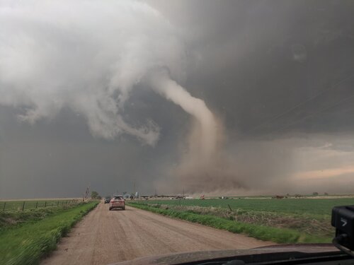
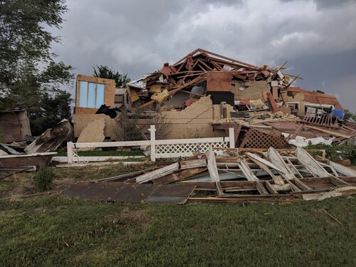
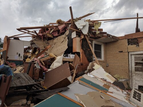
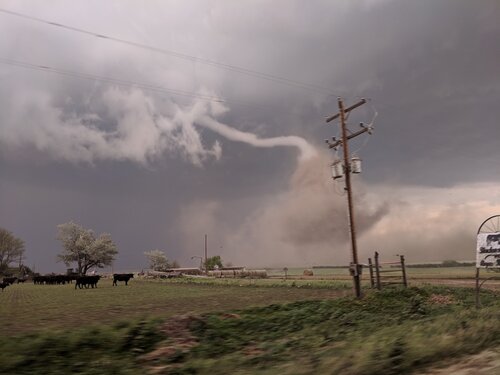
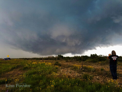
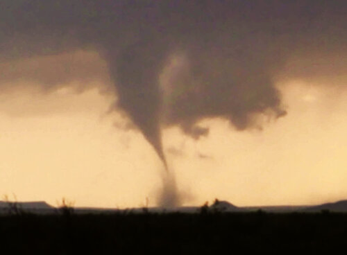
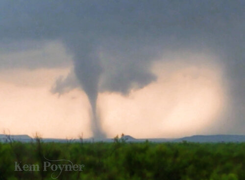
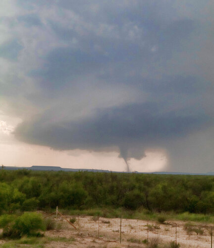
A wild and fantastic chase day to start the sequence of Plains events! I was on the northern target's storm of the day since Atwood, Kansas. I witnessed at least 3 tornadoes from the storm, all in Nebraska: a dusty cone/rope northwest of McCook, a long-lived photogenic stovepipe south of Farnham and a close-range dust bowl under a carouseling wall cloud north of Farnham.


may1719a.jpg
 
Last edited:
Went to McCook Nebraska to await initiation. We jumped when a cell popped up North of Atwood Kansas. That was around 3:30 PM. We stayed with that storm until about 1/2 hour after it crossed interstate 80 and called it quits. Ended up seeing four tornadoes total. I attached a couple of cell phone picsE2065DCF-35D9-4E19-AAD2-F58A211BB380.jpegAC8CE662-8AC0-4B44-9042-D7AC6FE8A020.jpeg65F4320F-9A1B-4831-A4A2-622A62F32F87.jpeg
 
Last edited:
We caught up with our first 2019 tornado east of Ft. Stockton, Texas on this setup. It lasted at least ten minutes from the first dust whirl beneath a broad, conical funnel to a slender stovepipe that just seemed to fade away. We were getting hit with large hail , possibly up to tennis ball size, as this was happening and I was trying to balance the smooth finish of my car vs. the spectacle we were watching off in the hills.

I didn't have much confidence at all in the tornadic potential of any storms in southern target. It primarily came down to preferring slow storm motions on a typically exhausting Day 1 drive from Arizona.

18138
 
1813918140Couple of pics from the cell phone here, will post rest later. Awesome day, left Manhattan Kansas around 1030am and got to Colby right before the storm of the day exploded over goodland, cell went from sprinkles to golf ball hail in 20 minutes time. I was on it from its start. Tracked it all the way to just south of Farnum, NE before I lost it. Top pic is the stove pipe northeast of stockville, bottom is the dusty rope west of McCook. Been since Chapman KS 2016 that I've had anything this good.
 
My day started wonderfully by capturing the start of the McCook tornado, but in the end I missed the rest of the tornadoes to the northeast due to a bad decision on going north out of McCook instead of east, a horrible road network, and not being able to chase too aggressively due to trying to avoid the hail. Finally got close again but was turned around by damage across the road effectively ending my chase. Haven’t gone through pics or my video yet, but threw up this video taken by my phone of the tornado forming west of McCook. Huge clear slot that reminded me of the Stanton NE tornado the day of Pilger.
 
I waited for initiation in Colby, KS off the dryline. Got on the storm that passed near Goodland and stuck with it all the way into Nebraska until after the McCook tornado dissipated. The still dry dirt road grid allowed me to be a bit more aggressive with this tornado, allowing for one of my best intercepts to date!

Unfortunately I cut my chase short to check on a damaged farm NW of McCook and missed the rest of the Nebraska tornadoes due to the deteriorated now mud road grid and limited paved options to catch back up. An elderly couple and their dog were present in the home when the tornado hit, but fortunately were just shaken with minor injuries. Outside of this, yesterday was one heck of a way to start off my chasecation!
 

Attachments

  • d26de958935e152d31bd28403aa4ccd5.jpg
    d26de958935e152d31bd28403aa4ccd5.jpg
    114.8 KB · Views: 3
  • f7da767e60302ac10a2775e02a6fcbfe-jpg.jpg
    f7da767e60302ac10a2775e02a6fcbfe-jpg.jpg
    337.1 KB · Views: 3
  • 79d48de4964419520e529a0a794fc030-jpg.jpg
    79d48de4964419520e529a0a794fc030-jpg.jpg
    281.2 KB · Views: 2
  • 9d1a29fedf0db7c82c8a4ed5e6060aa5-jpg.jpg
    9d1a29fedf0db7c82c8a4ed5e6060aa5-jpg.jpg
    154.3 KB · Views: 2
Had a pretty good day minus one tiny mistake to start out with that cost me a chance at closer views to the last several tornadoes. I dropped south from North Platte after it became clear this was going to be the storm of the day. When I got to Culbertson, I debated about just staying on 34 and waiting for it to get to me rather than dropping S on 17. But I saw it had recycled and thought it might produce just south so I headed down. It didn't except for a very high funnel, and I got stuck in the conga line of chasers (it would become a theme) waiting for the RFD and core to cross the road. After getting back to 34 I headed east and watched the beautiful ropeout of the first tornado (pictured below) which was positively gorgeous.

From that point on, though, I was behind the storm due to the poor road network and extremely slow driving of several people who were holding things up. At McCook I headed north and then east to Stockville where I caught the next two tornadoes - the dusty stovepipe and slender elephant trunk - while driving. I headed north on a dirt road with the rest of the horde then got stuck on 23 where the police had blocked off the highway. Taking mud roads around that set me back too far to see anything else and the day was basically over. That one decision to not wait on 34 set me behind everyone else and, without a good road network, prevented me from getting in position again. Lesson learned! But what a beautiful first tornado that was!

60782589_10102506734920553_4846114984234582016_o.jpg


60604349_10102506546423303_384559302825738240_o.jpg
 
I caught the McCook tornado, pretty much from start to finish, albeit from a fair distance to the SW of the tornado, with a big crowd of chasers a little south of Culbertson. I was the first or second one onto a sideroad that became very crowded, initially just to wait out the big hail hitting Culbertson at the time, but almost as soon as I pulled onto that road, there was the tornado. Not as close a view as others had, but a good place to see it go through dramatic changes in its appearance. Also caught what may have been another tornado from the same meso 15 minutes earlier south of Culbertson - it was reported as such by multiple spotters, but I couldn't tell. And later what was probably the tornado reported 8 miles NE of Cozad, although I was a long distance away, and my views of the other tornadoes in that area were blocked by rain. Basically I intercepted the storm 3 times; once in Kansas, again south of Culbertson from where I viewed the McCook tornado, and finally near Eustis. Also adding a pic of a spiky 2.5-inch hailstone I found in Culbertson after the McCook tornado. Full report will eventually follow, as time permits.

IMG_6938-e-fb.jpg

IMG_4465-e-fb.jpg

tornadovidcap3-fb.jpg
vidcap of likely 2nd tornado-fb.jpg

IMG_6923-e-fb.jpg

IMG_6940-e-cr-fb.jpg
 
Because of time restraints from driving from Arizona, I chose the Southern target. We started the day in Odessa. Saw towering cells going up to the Southwest and headed that direction. Encountered a wallcloud near Fort Stockton Texas. It finally produced this tornado that lasted about 10 minutes. It was kind of an odd formation...no horseshoe and the tornado formed next to and above the lowering.
 

Attachments

  • Fort Stockton wallcloud.jpg
    Fort Stockton wallcloud.jpg
    312.8 KB · Views: 1
  • Fort Stockton nostalga.jpg
    Fort Stockton nostalga.jpg
    102.5 KB · Views: 1
  • Fort Stockton tornado 2.jpg
    Fort Stockton tornado 2.jpg
    121.2 KB · Views: 1
  • Fort Stockton tornado1.jpg
    Fort Stockton tornado1.jpg
    151.2 KB · Views: 2
Me and my father have released a Weather Balloon with Go Pro into the McCook, NE, supercell as it was producing a tornado SW of McCook. Weather Balloon reached top speed of 227 km/h (we still need to verify this, but based on Doppler radar data it's realistic) and landed with only minor damage in the bluffs between Farnam and Cozad. It was recovered a few hours later after dark about 0.5 mile north of a path of another tornado. Unedited GoPro from launch till cloud base: https://vimeo.com/manage/337197809

Higher up in the storm the winds became turbulent and icing became an issue, covering the lens of the camera. The camera was suddenly switched off at an altitude of 4410 metres. The battery was still at over 50% and memory nearly empty. We believe an impact of a hail stone on the power button caused the switch off, or possibly the pressure created by icing. We will take measures to prevent this from happening on our next flight. The balloon then rapidly descended, even that it was still in the updraft, to 1480 metres, likely below cloud base, before beginning to ascend again. We believe this was due to the weight of ice. It then again ascended to 9860 metres above sea level before it's final slow descent to where it was recovered. Video from the final 6 minutes before camera was switched off:
Edited full flight video will be posted on my Facebook when there is a chase down day: Miroslav Provod
 
Last edited by a moderator:
Finally getting around to my chase account after I posted my video a couple of days ago of the McCook tornado forming.
I left Omaha in the morning with an initial target of North Platte. I had the same concerns many mentioned with the poor road network in the Sandhills and was really hoping things would avoid that area. I made it to North Platte and saw the big cell that had just formed near Goodland, but didn't want to commit to that storm that was that far south in case something formed that looked good closer to the stationary/warm front nearer North Platte.
I waited, initially holding off the temptation of going south to Kansas. I eventually dropped south to about 1/2 way to McCook before stopping again for about 10-15 minutes. At this point the storm looked great and was making it's way into Nebraska. Once the first report of a funnel came in south of McCook and there was nothing else really to chase I finally gave in(not sure why I was being so stubborn in dropping south).
I went west of McCook as the storm was still southwest of town bit. It had a nice wall cloud and soon I had hail falling at my location so I went back east just a bit out of the hail. It was at this point that I took the video I posted above of the tornado forming. From this vantage point though I had a horrible view of the tornado.
I then made the mistake of trying to go north out of McCook after the storm instead of going east to get back around to the front of the storm. This mistake never let me catch back up to the storms partially due to my overabundance of caution I take with my car and not wanting any hail damage and the poor road network.
On the way home I had to drive through the line of now severe storms that formed along the dryline/cold front on I-80. Once I cleared those storms the moon came out and illuminated the line rather brightly. I stopped and took some pictures of the line of storms and then headed home making it back to Omaha about 130am.

McCook1.jpg

McCook2.jpg

McCook3.jpg

McCook4.jpg

McCook5.jpg
 
I started the morning in the cold sector in the Nebraska panhandle where it did not feel like a chase day. But then I moved to North Platte where it was warmer and waited. Once the supercell formed near Goodland I started heading that way. But my first mistake was being too aggressive going after the storm in Kansas. I should have stopped in McCook, anticipated the storm's motion better and let it come to me. But my reason for going into Kansas was kind of dumb: I had never chased there before and this was my chance. The storm went tornado warned soon after reaching the base near Atwood.


Atwood Kansas Supercell
by Kevin Palmer, on Flickr

Somehow it seemed like it sped up once I reached it. With the 45 mph storm motion to the northeast, I quickly fell behind trying to use side roads. Back in Nebraska I watched this RFD cut and wall cloud form over the stone church.


About to Drop
by Kevin Palmer, on Flickr

This dusty EF-2 tornado dropped west of McCook 10 minutes later, and was 3-4 miles away from my location. Even though I had to use a telephoto lens to shoot it, I should be glad I was able to see it at all.


Elephant Trunk Tornado
by Kevin Palmer, on Flickr


My 2nd mistake was giving up on the storm too early. I assumed I would not be able to catch it again, but I made my way north anyway. I stopped for awhile to try and shoot some lightning bolts, when it started to cycle again.


Possible Funnel
by Kevin Palmer, on Flickr

After reading the latest warning text, I saw that the storm had slowed down to 25 mph and it was moving more easterly. I was not expecting that, so I quickly tried to catch back up with it. But I was too late. I almost got through to the other side of the hook near Farnam (didn't even have to core punch). But then I ran into the tornado damage path, with downed power lines on the highway. The side roads were too muddy at this point to find my way around, so that was the end of the chase. On my way back to North Platte there was a decent sunset. Another line of storms formed on the edge of the cold front. After dark the lightning was non-stop as the last cell moved off to the east. Below is a stack of 10 lightning shots.


A Glimpse of the Anvil
by Kevin Palmer, on Flickr


Strobe Lightning
by Kevin Palmer, on Flickr

This was the farthest I've ever driven to chase, but I was getting tired of waiting for setups closer to home. It was my first time chasing in Kansas (for a few minutes lol). It was also the first time I've driven through a snowstorm on the way home from a chase. Also, just like last year my season began in Nebraska and I captured a twister both times.
 
Back
Top