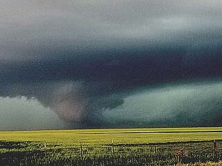
2019-05-07 REPORTS: KS/OK/TX

Joined
Jun 16, 2015
Messages
476
Location
Oklahoma City, OK
This chase was all over the place. I got to Amarillo even earlier than I was hoping and storms were already developing by early afternoon. I jumped north on the initial supercell just north of Amarillo, even though it was fairly clear that it was elevated. That, combined with weak low-level shear suggested that this was mainly going to be a hail producer.

Hail, it did produce. I found spiky/jagged hail up to golf ball size about six miles northwest of Fritch, TX. I'm sure the biggest hail was even larger, but it wasn't going to be worth it to try to find more. I kept with the storm for a while (avoiding the hail core), but eventually decided to head south.
190507_hailstones.jpg

A discrete storm was firing just north of Lubbock and that was my next target. I wouldn't get there until at least 5 p.m., but I figured that would be plenty of time, since the low-level jet wasn't going to start cranking until late afternoon/early evening.

Upon review and sharing photos with other chasers, it looks like I got to Tulia just in time for the tornado. It's barely visible in the photo below from 5:12 p.m., but you can just make it out on the right part of the storm. I got to a spot just southeast of Tulia at 5:09 p.m. and after those first few minutes, I didn't really see anything else that was conclusive. The photo below is a bit mushy, but it's the only picture I managed to get in that time frame and it was with my phone:
190507_tulia.jpg

I stayed with the storm until the Howardwick area, but the road I was on suddenly turned to dirt and it was probably for the better. The road was going to cross paths with a rain-wrapped circulation, so I bailed back south.

The chase wasn't completely over yet, as I went south, then east, in hopes to maybe catch something around sunset. By that time, I was in far southwestern Oklahoma. A couple of tornado warnings were issued for a new line of storms, but it was too dark and not safe enough to justify chasing any longer.

In my opinion, aside from storms initiating rather early in the afternoon, the day went as expected. Most model guidance showed a fairly brief window of discrete storms and there was strong model agreement among the convection allowing models that storms would merge and cluster fairly quickly. Still, if you look at the initial reports, SPC did a solid job.

Of note was an intense supercell that developed near I-10 in southwest Texas. I eluded to this potential earlier and if that target had been closer, I may have jumped on that.

Still, even though I barely caught a tornado an spent most of the chase fighting with chaser convergence and a lack of cell service around the canyons, I'd consider it another successful chase. The supercell by Tulia was very photogenic, especially early in its life cycle.
190507_wide.jpg

I may upload a video clip or two later, but for now, these photos catch most of the highlights in this chase.

Below is an alternate photo from Tulia, but this was from about 1-2 minutes after the tornado lifted and/or became rain-wrapped:
190507_sony.jpg

Edit to add a video clip. This is condensed video, at 8x speed. Most of it is near Tulia, but the short segment at the end is a little bit northeast of Tulia, later in the life cycle of the supercell:

Note that the thumbnail with the lightning strike was a coincidence... I didn't even know that happened with me in the shot, until the video processed.
 
Last edited:
Driving from Texarkana I chose to head to Lubbock at Childress but then ended up heading toward plainview with convection SW of there. Saw a sharp funnel halfway to the ground NW of Plainview then observed an impressive wall cloud transition to tornado SW of Tulia. It was a broad bowl to cone with fingers reaching to the ground occasionally. The thing took on an orangish color like it was picking up dust but maybe it was whipping up muddy water off the wet fields. I then made my way over to SW OK and saw 3 tornadoes between 1130 and 12 between Hobart and Rocky. Hard to make out in the lightning flashes but could have been the same tornado I suppose, just lost sight of it at times. Mostly back lit by occasional lightning, but did see several power flashes. Sharing from my phone. I think I will wait and edit DSLR pics after season is over. 20190507_172031.jpg

20190507_170326.jpg
 
I decided to chase with Travis McMillan today. We pinpointed the Texas Panhandle and planned to chase the triple point. Travis decided to drive down the day before and spent the night in Amarillo, while I waited to drive down until the morning of so that I could avoid taking another day off work.

My whole drive down this morning, I was surrounded by fog and rain, which was not good. I kept calling Travis, asking what his thoughts were on where we should start, and he was clueless. The storms were just rain, perhaps a squall line, but definitely nothing that even remotely reassembled the super cells that were forecast.

I finally meet up with Travis around 2pm in Stinnett, TX. We looked at the radar and couldn't decide on anything. Looking at the spotter network icons spread out across the entire Texas Panhandle, it was clear that nobody knew where to go.

After discussing our options for about half an hour, suddenly two storms went tornado warned. One about 1.5 hours north of us (the Spearman tornado), and another 30 minutes south of us. The one 1.5 hours north of us was a confirmed tornado, while the one 30 minutes south of us was just radar indicated rotation. We decided to go south and hope for the best. When we got there, the west side of the storm looked good, but didn't show any rotation on radar; the east side of the storm showed radar rotation, but visually looked like it was just turning into a rain shaft.

It was starting to rain on us and cover our visibility, so we decided to drive a few miles south to get a better view of the storm. While driving, Travis called me and we made the decision to abandon that storm and move further south to the Tulia storm.

While watching the Tulia storm, we ran into @Daniel Shaw who was watching the same storm, which by this time was tornado warned with a confirmed tornado on the ground. It was a nice little spot, with some cows hanging out checking us it.

17947

I had just enough time to say hi to Dan when he started yelling at everyone, "THERE'S A RAIN WRAPPED TORNADO HEADED STRAIGHT FOR US! WE'VE GOT TO GET OUT OF HERE!" He quickly packed up his three cameras and drove off to the south. I checked with Travis who was monitoring the radar, and he concurred. We beelined south to safety, and continued watching the storm.

The storm remained tornado warned for about 2 hours, but we never actually saw the tornado because of the high precipitation. There was a moment where we thought we might have seen a wedge, but when we re-positioned closer to the storm, it wasn't actually reaching the ground. I think we may have seen it for a brief second, but I'm not 100% sure.

Sometime around 6pm, Travis decided there was nothing chaseable that we could get to before it got dark. He decided to drive home so that he could make it back for work tomorrow.

I spent another 30 minutes trying to decide what to do, and finally decided to just call it a day. I grabbed a hotel in Amarillo, and I'll drive back home Wednesday. I have no plans to chase Wednesday because I just don't think the setup is good enough to take another day off work.

 
Day 2 in a frustrating chase trip. I left Wichita at 8AM, in what I thought would be plenty of time to get to Amarillo and refine the target for the day. After nearly constant road construction speed restrictions on Highway 60, I arrived just after 2PM. But there was no time to refine the target, storms had already fired. The one item I had identified from radar loops was an outflow boundary left from overnight storms. I figured this would be north of I-40 by storm time.

I drove up to the storm near Ady, finding it cold with no surface inflow. I dropped south to Bushland and awaited the next cell to approach. It ramped up in intensity right overhead, and I stairstepped northeast to stay with it all the way to Highway 87 north of Amarillo. Surface inflow was present with this storm, but it was getting destroyed by the RFD. This circulation tightened up, but had no chance with the overpowering RFD headed north:

may719a.jpg

Due to the constant driving to keep up, I didn't shoot any stills of the storm. I figured I could pull from the dashcams later anyway. I finally bailed and headed for the storm near Tulia. I was still 25 miles away when the tornadoes were reported.

Seeing an intercept path ahead that would take me into the Palo Duro Canyon with no services, I needed to stop and get gas again prior to this. By the time I realized it, I was south of Canyon on I-27. I thought I'd get gas in Happy. But, I discovered upon arrival that there were no gas stations in the town. I would have to go to Tulia to fuel up, completely losing the storm. In Tulia, my credit card would not work at the pump, so I had to go inside to the cashier. When I finally got back on the road, I was way out of position. I managed to catch up to the RFD of the strong circulation near Vigo Park, but with the blinding rain, I couldn't see a thing.

I continued north to I-40 in a last attempt to get back ahead. I was successful, beating the circulation to Alanreed/McLean. It was completely rain-wrapped and invisible, even from within the notch of the storm. With darkness setting in, I decided to call the tornado chase and head into Oklahoma City for upward lightning as the MCS moved through. I arrived far enough ahead that I was able to get a few hours' sleep before the storms' arrival, so I guess technically this next part could be considered a new chase. But whatever. I went out in the trailing stratiform to capture lightning to the towers, but the wind continually shifted and blew rain onto the lens, requiring several frustrating repositions. OKC is actually one of the worst places to chase, finding roadside pull-offs with open views is very difficult. I managed to capture one upward flash to the towers before fog obscured everything.

may819a.jpg

The fog was neither here nor there: the stratiform shield raced away early, leaving the rest of the morning lightning-less. I went back to my hotel at 7:30AM and slept a few more hours before checkout time. I realized as I was on the Turner Turnpike heading home that I had forgotten to archive my dashcam video from Tuesday's chase, meaning all of that imagery from the Amarillo storm was lost.

Slow motion lightning video is included here:

 
Last edited:
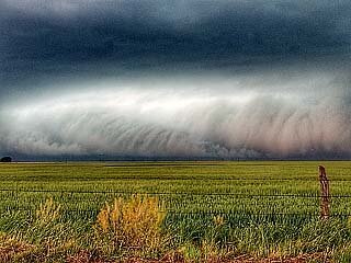
The day started out a little iffy on trying to decide a target area. The triple point beckoned, but I was hoping for something more discrete so I set Plainview in my sites. I arrived there about 1 pm and took a look at what was popping on the radar and decided to make a play for some cells going up father north towards Happy. Nothing really happened with the smaller cells so I decided to cut back down to Tulia to wait for the larger one to come up from Lubbock. I got south of Tulia just in time to see it try to start dropping. Like a lot of folks I never saw anything definitive because of all the rain wrap.

17955

17957

17958

I followed it all the way up into town and east, but opted to try to swing wide to the east due to the heavy chaser convergence and unknown quality of the road network. By the time I got back on it the whole thing just became rain obscured. I considered trying to get up to Clarendon, but with the evening approaching and more storms forecast to cut across my path home I decided to call it a day and head back to DFW.

This video is sped up 8x and covers the time from when I first got position on it until I decided to go east. Forgive the cheesy music, but I can't stand a silent video.


Attachments

  • DSC_0502-4 (Medium).jpg
    DSC_0502-4 (Medium).jpg
    89.5 KB · Views: 0
@Chadwick Stelzl and myself targeted the budge in the dryline and intercepted a lone cell near Edmonson TX with relatively few chasers on it. That would change over the next few hours as the masses drove south from the mess north of Amarillo. It produced a brief funnel near Edmonson about 4:15 pm just before it became tor warned.

1.jpg

The funnel dissipated and this is what it looked like around 4:45 pm from north of Edmonson.

2.jpg

3.jpg


As we repositioned to stay on it, multiple other chasers reported it was on the ground. It became rain wrapped and we never saw it. We ended up northwest of Tulia where I got this nice pano at 5:43 pm.

4.jpg

Just after 6 pm, we ran into some of the worst chaser convergence I have ever seen. Car after car was popping out of the RFD heading east on FM 146 towards Vigo Park TX. We where on a north bound road and where trying to turn east but had great difficulty because the cars in front of us either stopped in the middle of the road to take pictures or they where too afraid to pull out into the long line of traffic going east bound on FM 146. We finally got east then headed southeast towards Silverton so we could get across Caprock Canyon. We passed @Daniel Shaw along the way and he would latter document the traffic in a tweet: . This was a really dangerous situation. A rain wrapped likely tornado, tons of really inexperienced chasers behaving badly, and a road network that ended at the rim of a canyon.

We got across the canyon on 256 and ended up in Clarendon TX where we decided to give up on that cell and headed to a new line that had formed to our east. We took 203 to Wellington then crossed into OK and the road becomes 9. This paid off, as the storm right in front of us became tor warned. We had to hold up to keep from driving into the storm near Vinson OK. It was dark, but all we could see was a wall cloud. Once we where sure the area of interest had crossed the road, we gave up and headed back to DFW. It was a 854 mile chase, and other than the chaser convergences it was a fun one. Lesson Learned - you have to give storms more space on SPC enhanced 15% hatched tor days - as they sure draw a huge crowd.
 
We left Kansas City at 6am for the long trip to our target of Canyon Texas. A boundary was just SW of Amarillo so we watched a cell form by Hereford TX wanting to see what it did once it hit that boundary. It quickly started looking good and watched a few funnels form but could never confirm or see it touch down. I saw the cell down by Tulia like everyone else and headed that way. We went through the canyon which now in hindsight I wish we just went down 27 and core punched. Either way we got these photos of the cell and watched as it dropped the needle. Like everyone else we hauled butt to get out of its way later back through the canyon. We eventually made it to the Oklahoma storms and saw a night tornado (radar shot below) between lightning shots. All and all a good structure day with wimpy tornadoes in two states. Note all photos besides radar taken by chase partner Allison Marshall.

1.jpg
2.jpg
3.jpg
4.jpg
5.jpg
7.jpg
6.jpg
 
Left work Monday in the NW suburbs of Chicago for a marathon chase, got a few hours sleep in Tulsa and then off for the Texas Panhandle. I analyzed data in McLean and decided nothing to the north was worth pursuing and south was the preferred area, as it was a storm was just getting going near Lubbock so without much hesitation I took off for the intercept. The drive there took me through the canyons and even though I've chased the panhandle a few times in the past I'd never been in the canyons. Two things struck me, the beauty of the canyons and the lack of roads, in fact I don't remember any other single road except for the one I was on heading south. I almost abandoned the chase right there, if the storm was going to move into the canyons then chasing would be extremely difficult...and dangerous without any escape routes. But after almost turning around I decided to go forward and hope that I'd at least have a couple of hours before the storm hit the canyons. Just as I was getting on the storm the first tornado report came in and like always when that happened it gave me mixed feelings, great that this was already capable of producing a tornado and crap, I better not have missed the only tornado that this storm produces! Within 15 minutes I observed what I thought to be a large truncated cone tornado but couldn't discern any ground circulation or debris. But just a couple minutes later a funnel formed and while I couldn't verify if it touched the ground it was ultimately reported as a tornado. The storm did ultimately move over the canyons and I had to backtrack and go around the canyon after getting as far as I could before getting cut off by the storm. After a long ass drive around the canyon I finally caught up to the storm again but wasn't able to get into position to see the tornado that crossed I-40 before the storm moved onward into the growing darkness. At that point I called it a chase and after a nice stay at a hotel in Weatherford, Oklahoma I made the 12+ hour trip and was home Wednesday night, ending a 2300+ mile 2 day marathon and my first chase of the season. It was great to get out again, after all these years my amazement and fascination with storms hasn't faded one bit, I really had a great time and I'm anxiously awaiting the next chase!

 
Last edited:
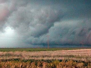
Good day all, Here is my report for storms for May 7, 2019...

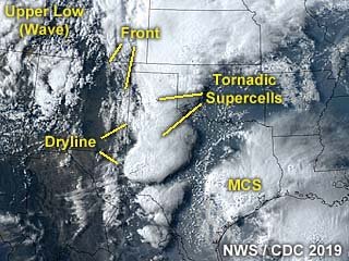
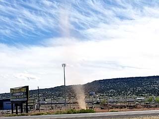
Chase Summary: May 7 was both an "all-nighter" travel day and successful "cutting it close" chase in the western Texas Panhandle area near Amarillo, with two tornadoes ultimately intercepted south of there near Tulia. During the end of the long drive, the leading edge of the powerful upper wave was reached. After seeing wet snow in New Mexico earlier that morning, clear skies gave away to a distinct band of high clouds nearing the TX / NM border, with dry air and even dust devils observed. The Storm Prediction Center (SPC) had a high-end moderate risk for the Texas Panhandle, centered near Amarillo, with 15% tornado and 45% hail probabilities in their 13z and 1630z outlooks, both hatched for significant. Wind probabilities were a bit east at 45%. Supercell storms were encountered upon entering west Texas and crossing the dryline and into the high CAPE environments. Synoptically, a low pressure area was over SE Colorado with a distinct dryline and frontal boundary bowing into it from the north. Upper level support was provided by the aforementioned upper trough catching back up with me from the west. Once in Amarillo, the chase was on, passing some supercell storms and targeting a tornadic one to the south near Tulia. The SPC had Mesoscale Discussion (MCD) 573 and tornado watch box 144 valid until 10 PM CDT for the area. I headed south on I-27 via the west side of Amarillo, intercepting the Tulia storm and tornadoes east of Tulia west of Highway 207 near Wayside just before 6 PM CDT. The storm was followed to the Palo Duro Canyon via Highway 207 to 287. The storms evolved to an MCS and I wrapped up chasing around 8 PM, heading north of 287 out of Goodnight to I-40, then west to Amarillo to eat at the Big Texan, and into a motel there for the night, instantly falling asleep as soon as my head was on the pillow, wrapping up a staggering 40 hours without sleep!

Storm Interception Details Are Below

1). May 7, 5:30 PM
- Interception and indirect penetration of an extremely severe and tornadic thunderstorm near Tulia, Texas in Swisher County, to the east of I-27 and Highways 275 and 207. The storm was a powerful HP storm that produced a large tornado near Tulia. The end of this tornado was observed during its wedge phase from near Wayside, Texas looking towards the WSW into the notch of the HP storm. The storm cycled and produced a second multi-vortex tornado north of Wayside before becoming rain wrapped. The storm evolved to a line / bowing segment thereafter. The HP storm also had a striking visual appearance, with intense FFD inflow banding (almost to ground level) as well as RFD and striations. Frequent lightning (with some close hits), torrential rains, 60 to 70 MPH winds, and hail up to 2" (the main core was avoided). The storm remained over open farmland so no damage was observed. Flash flooding was observed along Highway 207 in the Palo Duro Canyon. Conditions causing the storms were a dryline, outflow boundaries, surface heating, a low pressure system, and an upper trough. Documentation was digital stills and HD video. A 2016 Jeep Wrangler was used in this chase. A tornado watch was also valid for the area until 10 PM CDT.

Pictures For May 7, 2019 Are Below

m20sat1.jpg

Above: Annotated satellite image showing the synoptic setup as well as supercell storms over the Texas Panhandle at around 23z on May 7.

m20ddev.jpg

Above: A dust devil churns on the north side of I-40 while heading through eastern New Mexico en-route to the Texas Panhandle on May 7.

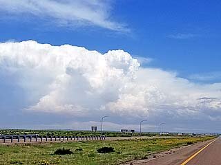
m20sc1.jpg

Above: View looking east at one of several supercells being visually confirmed from the west of Amarillo at about 5 PM CDT on May 7. This was after finally reaching the dryline boundary and well ahead of the upper trough axis.

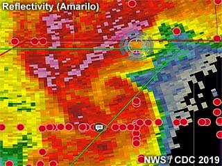
m20rad1.jpg

Above: Base reflectivity of the Tulia, Texas supercell at about 5:40 PM CDT on May 7 off the Amarillo radar. My position is the blue cross-hair, and directly in the path of a rain wrapped tornado. Red dots are other storm chasers.

m20tor2.jpg

Above: Close up view of the late stages of the wedge / multi-vortex tornado as is passes to the north of Tulia, Texas on May 7 at around 5:50 PM CDT.

m20svc1.jpg

Above: Looking towards the west from south of Wayside, Texas, the incredible stream-wise vorticity current along the supercell FFD (forward flank downdraft) screams from right to left into the main updraft. The horizontal tube, or "rotor", is marked by ground scraping low clouds as it is pulled into the storm as it cycles up again late on May 7.

m20tor3.jpg

Above: The RFD and FFD meet in the so called "notch" of the HP supercell as it cycles up again near Wayside, Texas. The view is to the southwest and west. A multi vortex tornado is developing, and a suction vortex can be seen in the center of the picture just to the left of the pole. This was around 6 PM on May 7 in Swisher County.

Note: For DETAILS on this storm / setup as well as others in May 2019 … Please visit the link BELOW for more information!

 
Back
Top