Quincy Vagell
EF4
I started the chase near Turkey, TX, as agitated cumulus was observed along the dryline relatively early. There was one robust storm north of I-40, otherwise some other cells were ongoing just to the north of Turkey. I wanted to see if anything would go up farther south along the dryline, but that didn't happen.
Before storms really got going, there was a bit of mammatus to see, so I stopped for a few photos. I had a feeling it would be a bit longer before storms encountered a more favorable environment to the east. As it turns out, one storm in a cluster, near Memphis, quickly became a dominant supercell.

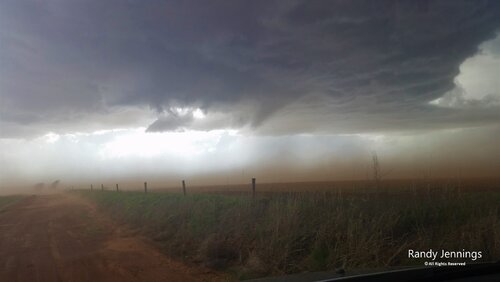
It was around this time that I set myself up near Newlin, TX, as I noted quite a bit of blowing dust in the distance. I got up close and as expected, dusty fields were in the inflow region, with plumes of dust channeling into the storm. I couldn't get much footage without my face, hands and car becoming a dusty mess, so I booked east to try to stay ahead of the storm. Prior to leaving, I did broadcast this brief livestream.
From there, I took an iffy road "K" east, hoping that I could make it to US-62 before the storm turned right, and/or road conditions became unmanageable. It worked out okay, as the road wasn't very bad at all. Once at US-62, I had to make a decision. There was no real way to get east toward Hollis without core punching and to go south would involve going all the way to Childress. After some hesitation, it was finally clear that the better photo opportunities for structure would probably be to the south.

The next stop was on some rural roads just east of Childress, watching the storm over the river in Oklahoma. I saw very few chasers at all down there, as most seemed to favor being farther north. I also think that others had positioned themselves well, on the east/southeast side of the storm, so that they didn't need to bail south to US-287.

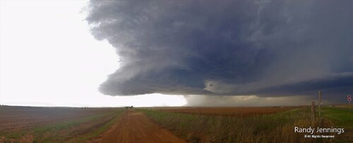
After going southeast to Quanah, I turned north on TX-6 and had really good timing with making it to the Oklahoma border as structure became very pronounced from my vantage point. The only thing I wish I had done was use my new camera more, so this photo (one of my favorites from any chase in Oklahoma) and most of the others in this post were from my iPhone.

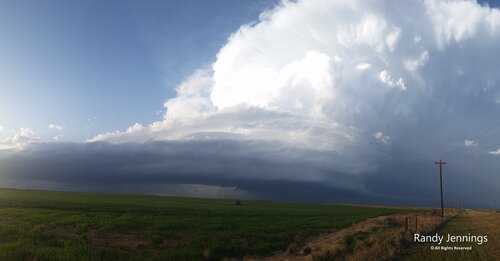
I went up into Eldorado to get a closer look at the storm. Structure had more or less peaked by this time and I was fairly certain that the tornado threat wasn't worthwhile enough to hang back too close. I took rural roads east to Elmer for a few more photo opportunities.

Mid-level rotation was very pronounced on radar, but low-level rotation was never all that impressive. There were a few times that it looked like, just maybe, a wall cloud was trying to get organized, but fairly dry conditions in the lowest 1km AGL were not very favorable for tornadoes.

With that said, moisture return was pretty much right on par with what the 12z HRRR guidance was showing. The 12z HRRR showed 53-56F dew-points in southwestern Oklahoma at 00z and that's what verified. Still, the moisture wasn't substantial enough to support a bonafide tornado threat.
Overall, this was actually one of my better chases in Oklahoma, even though it was barely in Oklahoma. I haven't seen a lot of really great structure in the state, but interestingly enough, one of my previous favorite chases in Oklahoma was only a couple of towns east of today's action, in Tipton... As far as expectations went, I figured there was probably going to be an isolated supercell or two today. Wind profiles were highly favorable for supercells and capping was enough to keep storms fairly isolated. I'd say expectations were met, if not slightly exceeded.
I would also like to add that a few other chasers had an even better view of structure today. Well done. I may eventually post some video, but for now, I'll leave it to pictures since I'm sure some of you have more remarkable video footage to share.
Before storms really got going, there was a bit of mammatus to see, so I stopped for a few photos. I had a feeling it would be a bit longer before storms encountered a more favorable environment to the east. As it turns out, one storm in a cluster, near Memphis, quickly became a dominant supercell.

It was around this time that I set myself up near Newlin, TX, as I noted quite a bit of blowing dust in the distance. I got up close and as expected, dusty fields were in the inflow region, with plumes of dust channeling into the storm. I couldn't get much footage without my face, hands and car becoming a dusty mess, so I booked east to try to stay ahead of the storm. Prior to leaving, I did broadcast this brief livestream.
From there, I took an iffy road "K" east, hoping that I could make it to US-62 before the storm turned right, and/or road conditions became unmanageable. It worked out okay, as the road wasn't very bad at all. Once at US-62, I had to make a decision. There was no real way to get east toward Hollis without core punching and to go south would involve going all the way to Childress. After some hesitation, it was finally clear that the better photo opportunities for structure would probably be to the south.

The next stop was on some rural roads just east of Childress, watching the storm over the river in Oklahoma. I saw very few chasers at all down there, as most seemed to favor being farther north. I also think that others had positioned themselves well, on the east/southeast side of the storm, so that they didn't need to bail south to US-287.

After going southeast to Quanah, I turned north on TX-6 and had really good timing with making it to the Oklahoma border as structure became very pronounced from my vantage point. The only thing I wish I had done was use my new camera more, so this photo (one of my favorites from any chase in Oklahoma) and most of the others in this post were from my iPhone.

I went up into Eldorado to get a closer look at the storm. Structure had more or less peaked by this time and I was fairly certain that the tornado threat wasn't worthwhile enough to hang back too close. I took rural roads east to Elmer for a few more photo opportunities.

Mid-level rotation was very pronounced on radar, but low-level rotation was never all that impressive. There were a few times that it looked like, just maybe, a wall cloud was trying to get organized, but fairly dry conditions in the lowest 1km AGL were not very favorable for tornadoes.

With that said, moisture return was pretty much right on par with what the 12z HRRR guidance was showing. The 12z HRRR showed 53-56F dew-points in southwestern Oklahoma at 00z and that's what verified. Still, the moisture wasn't substantial enough to support a bonafide tornado threat.
Overall, this was actually one of my better chases in Oklahoma, even though it was barely in Oklahoma. I haven't seen a lot of really great structure in the state, but interestingly enough, one of my previous favorite chases in Oklahoma was only a couple of towns east of today's action, in Tipton... As far as expectations went, I figured there was probably going to be an isolated supercell or two today. Wind profiles were highly favorable for supercells and capping was enough to keep storms fairly isolated. I'd say expectations were met, if not slightly exceeded.
I would also like to add that a few other chasers had an even better view of structure today. Well done. I may eventually post some video, but for now, I'll leave it to pictures since I'm sure some of you have more remarkable video footage to share.
Last edited:


