Ethan Schisler
EF5
Okay I will put Texas in the title since I'm sure a few of you were down there chasing.
Anyway....today really wasn't supposed to be a chase day across Illinois, there was a non-zero risk of tornadoes with any showers that went up in the wake of the morning wave. However temperatures and instability never got out of the upper 50's and lower 60's so I wrote the threat off and took a nap instead. I woke up from my mid afternoon/evening nap around 7 oclock and just looked at radar and saw a shower going up east of Abingdon and decided that I would go out and try for a sunset timelapse. I followed this "storm" from just east of town here, where it started ramping up and looking pretty impressive.
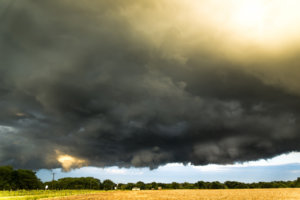
Delong, IL storm structure shot.
It was about sunset here, so the lighting is pretty dramatic. Anyway I followed the storm through Delong and had a funnel cloud come about halfway to the ground, but I couldn't confirm touchdown because of obstructions. I saw about 2 or 3 other funnels on this storm and several wall cloud type features, but it never appeared to be quite a supercell. Anyway around 8:00PM I pulled over outside Maquon, IL where I had a nice lowering and almost occlusion just to my east. I took this cell phone panaromic before the tornado touched down...
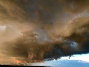
The sunset was amazing already back to the west, so I couldn't figure out which one to film. I really didn't think this would produce a tornado, however it did. The feature on the right was moving to the left while the lowering to the left was pulling southward. I noticed a plume of dust go up under that wall cloud and eventually a funnel extended partway out of the cloud base and the debris cloud reached all the way to the cloud base. The tornado persisted about 1 to 2 minutes just outside Maquon, IL around 8:05PM
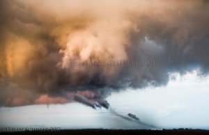
Landspout-style tornado outside Maquon, IL around 8:05PM
I called NWS Lincoln and they told me they had other reports as well, but the storm was going outflow dominant by this point and the sun was setting behind me, so I saw the rationale for no tornado warning on this. Anyway I was about a mile from the touch-down to the west, I could see quite a bit of dust and small debris getting kicked up and eventually it just kinda roped out after a couple minutes. I doubt much if any damage was done at all. Here is the sunset that I had to my back.

Maquon, IL Post Tornado Sunset
Some days you just don't expect and today was one of those days, just dumb luck for me. NWS Lincoln did confirm the touchdown of a tornado in that area and then another one further south in Central Illinois, so a little magic going on today.
Anyway....today really wasn't supposed to be a chase day across Illinois, there was a non-zero risk of tornadoes with any showers that went up in the wake of the morning wave. However temperatures and instability never got out of the upper 50's and lower 60's so I wrote the threat off and took a nap instead. I woke up from my mid afternoon/evening nap around 7 oclock and just looked at radar and saw a shower going up east of Abingdon and decided that I would go out and try for a sunset timelapse. I followed this "storm" from just east of town here, where it started ramping up and looking pretty impressive.

Delong, IL storm structure shot.
It was about sunset here, so the lighting is pretty dramatic. Anyway I followed the storm through Delong and had a funnel cloud come about halfway to the ground, but I couldn't confirm touchdown because of obstructions. I saw about 2 or 3 other funnels on this storm and several wall cloud type features, but it never appeared to be quite a supercell. Anyway around 8:00PM I pulled over outside Maquon, IL where I had a nice lowering and almost occlusion just to my east. I took this cell phone panaromic before the tornado touched down...

The sunset was amazing already back to the west, so I couldn't figure out which one to film. I really didn't think this would produce a tornado, however it did. The feature on the right was moving to the left while the lowering to the left was pulling southward. I noticed a plume of dust go up under that wall cloud and eventually a funnel extended partway out of the cloud base and the debris cloud reached all the way to the cloud base. The tornado persisted about 1 to 2 minutes just outside Maquon, IL around 8:05PM

Landspout-style tornado outside Maquon, IL around 8:05PM
I called NWS Lincoln and they told me they had other reports as well, but the storm was going outflow dominant by this point and the sun was setting behind me, so I saw the rationale for no tornado warning on this. Anyway I was about a mile from the touch-down to the west, I could see quite a bit of dust and small debris getting kicked up and eventually it just kinda roped out after a couple minutes. I doubt much if any damage was done at all. Here is the sunset that I had to my back.

Maquon, IL Post Tornado Sunset
Some days you just don't expect and today was one of those days, just dumb luck for me. NWS Lincoln did confirm the touchdown of a tornado in that area and then another one further south in Central Illinois, so a little magic going on today.
Attachments
Last edited:
