2017-05-16 REPORTS: TX, OK, KS, NE, IA, MN, WI

Jeff Duda

site owner, PhD
Staff member
Site owner
Supporter
Joined
Oct 7, 2008
Messages
3,723
Location
Denver, CO
I'll spill my story while it's still fresh in my memory.

I doubt I'll end up posting any pictures or video. While I saw some stuff, it probably wasn't as good as what others saw.

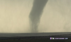
Summary: saw the beginning of the big rain-wrapped tornado near Elk City after flying southeast 100 miles from the OK panhandle, then a popped tire ended my chase (but it was basically over at that point anyway).

I didn't want to target the E TX panhandle. I'm not a fan of the road network there, and I wanted to experience different chase territory. I liked what I saw in the OK PH, so I headed for Woodward. I got there around 1 PM and while lunching, noticed the first storms building to the west. So I went northwest along US 412 towards Beaver. A slight equipment malfunction and a one-lane pilot-car situation on 412 got me to the storm a tad later than I would have liked to, but I still got there with a few minutes to spare before it wrapped up a circulation right in front of me on US 270 just south of Beaver. That was actually also the only time during this chase I got any hail. I stuck with this storm too long and lost it due to poor road conditions near Beaver.

I turned back to 270 (from southeast of Beaver) to begin looking at the next tornado warned storm coming up at me. I was also paying attention to the south, knowing at some point I was going to switch target areas and go for the southern play. But it was impossible to ignore a tornado warned supercell just to my southwest. I played with it for a bit near Balko and Elmwood. Despite some pretty updraft structure and a nice broad base with lowerings, the first storm had clearly worked over the environment the second storm was ingesting, and surface flow was weak or non existent, so I was pretty sure this storm was not going to produce any tornadoes. I had to make the decision to break from this area and get in position for the TX PH storms.

Not wanting to deal with the construction on 412 again, I cut across Lipscomb County, TX and jumped on US 283 south, booking it as I began to fear I may bust given how out of position I was. However, every time I checked the radar against my position, I seemed to be "ahead of schedule", and kept pressing south instead of south and east. I made it all the way to Cheyenne well in time to get in position on the former McLean storm (now the northern of two tornado warned supercells). I wasted maybe 10 minutes venturing a few miles west of Cheyenne towards the now two mesos before realizing that was totally stupid and going for broke on tail end Charlie. I worked out that going south through Sayre would not be a good idea, so I cut east to Elk City, then got south on OK-34.

I got through the leading edge of the FFD of the storm with a few minutes to spare, although as I crossed the OK-34/OK-152 intersection and saw many chasers sitting there I thought to myself "not a great place to stop" (because of the reports of 4"+ hail coming from the storm). I got a good view of the storm in a relatively safe position just north of Carter quite awhile before the tornado began. That thing had a beaver tail that seemed to stretch to infinity to the NE. I made sure to grab a panorama of that with my phone.

Seeing a solid base on the storm well to my WSW, I snuck to west of Carter where I watched the storm spin up the Elk City tornado. It wasn't until I saw dust being lofted due to inflow start to whirl around that I could tell it was tornadoing, even without rapid rotation at cloud base. It gradually tightened and looked like it was gonna drop a monster, but of course the rain came in and completely obscured it. I had a hairy moment east of 34 north of Carter when I tried to cut across the non-paved grid instead of staying on 34 or 152. I was on County Road 1960 near Bank R when I started to enter the circulation. The dirt road quickly became muddy and my car quickly started to struggle to handle it, especially given the high westerly winds. I managed to backtrack south and back to 34 and then 152, noting snapped power poles just south of 152 on 34. There was other scattered light debris, but everything seemed to be leaning the same direction, so maybe whatever did that was more RFD than tornado. There were other structures along 152 near where the tornado probably crossed that didn't have any damage; I only saw scattered light debris on 152.

I finally found the circus line of chasers as I approached OK-6 on 152. That intersection took a long time to get through because of the stopping rule. I then cut up N2080 Rd to Canute to get back in position. Just before turning east on E1120 Rd, some large piece of debris appeared on the road and I ran it over, popping my left front tire. This was not from the tornado, but I don't know exactly what it was. Looked like it might have been a motor for a kitchen appliance or something. Lots of copper wire coils and other wire sticking out. It was probably some metal spiky piece that did the job, though. Thankfully there was a very helpful chaser a few miles down the road who helped me swap in my spare in very short time. To Tray or Troy C (can't remember the name...hadn't heard of him before but he said he had been chasing for 25 years and looked the part), thank you so much for stepping aside for a few minutes to help me out!

We changed the tire so fast I actually didn't lose much time on the storm, but I was basically done by that point anyway. I limped back to I-40 and then started home. It was weird how power was out basically all along I-40 from Clinton to Weatherford despite neither being hit by the storm directly. There was only one servicable gas station along that stretch at Custer City, and the place had lines of people waiting to get gas. Took awhile to get through that and then limp my ass on home on a not-full-size spare.
 
I started the day in Shamrock. Went west to the first storm at Jericho to find a decent looking occlusion that I lost in the rain. Moved to the next storm to the south and east, catching a nice long-lasting tornado south of McLean as a downpour of 2" and 3" hail made my shields worth the trouble. Made the mistake of trying to flank the next storm to the south at Wellington, then lost it for the better part of 2 hours thanks to a nonexistent east-west road that maps showed connecting south of Sayre. I finally re-intercepted at Clinton, keeping up with the RFD punch and numerous funnels, but no other for-sure tornadoes. All in all a pretty nice day.


Attachments

  • may1617a.jpg
    may1617a.jpg
    159.7 KB · Views: 3
Last edited:
I'll keep this short because it's not very interesting. My day was very similar to Jeff's, minus the nader.

I didnt get a mile from home (in SE CO) before saying to myself "the day is ruined", because at 12:25PM MDT I was already eyeballing an anvilled storm right at my target, SW KS/OK PH, 2+ hours away. Well, I did see a rotating WC north of Liberal, then arrived in Beaver to witness another rotating WC, but then the storm immediately started looking sickly, so I decided my best bet was to drop south.

Got to Cheyenne just in time to catch a rotating WC there. Storm then seemed to be done. Storm to the south looked like a jelly bean on radar. No thanks. Browsed the net for awhile. Looked at NAM for Thursday. Finally went back to radar. Oops! Big hook! Got into position E of Elk City. Another... drum roll... rotating WC. Found one gas station open, where the sign said 2.09 and at the pump it was 2.45. Owner obviously knew it was the only station open (generator?) and was gouging. Special place in hell...
 
IMG_0075.JPG Got a late start leaving Guyman in the morning due to an urgent need of break pads. We were heading toward Childress when the first storm popped up in front of us near Borger. Decided to follow it for a while and never ended up leaving it, even though we had a few discussions about bailing South.
We saw one funnel cloud about a half hour before it was warned and another after it merged with the storm South of it. That was all we would see because of the difficulty of trying to keep up with it and the intense rain wrapping it was doing. The storms were really hauling. We came across the damage path two different times while playing the "try to catch up" game with the storm. At one point near Minneola we ran into some good hail which really ended up being the highlight of the day.
 
What a day! Headed out towards my target of Shamrock, TX and got on the storm near McLean, TX shortly after arriving. I was treated to a beautiful tornado on a fairly slow moving storm. Got some solid video all on the tripod from one spot. Can't complain about that.


1013a72046b3c9573fe0cfacd3010e70.jpg
5d3927f55e54937814a4d26580bc5c13.jpg
bb732063b9af12e856a9e0789923b55d.jpg
 

Attachments

  • 7d7c8d567db1ed580282730c0839efc1.jpg
    181.5 KB · Views: 3
  • 6ed4298636aa5f742e4c2c0c6c36a3a8.jpg
    154.8 KB · Views: 4
  • 6ed4298636aa5f742e4c2c0c6c36a3a8.jpg
    154.8 KB · Views: 4
  • 3164fe804152680c3dae46f65e680235.jpg
    155.4 KB · Views: 4
  • 7d7c8d567db1ed580282730c0839efc1.jpg
    181.5 KB · Views: 3
  • 6ed4298636aa5f742e4c2c0c6c36a3a8.jpg
    154.8 KB · Views: 1
  • 7d7c8d567db1ed580282730c0839efc1.jpg
    181.5 KB · Views: 2
  • 3164fe804152680c3dae46f65e680235.jpg
    155.4 KB · Views: 2
  • 6ed4298636aa5f742e4c2c0c6c36a3a8.jpg
    154.8 KB · Views: 2
  • 7d7c8d567db1ed580282730c0839efc1.jpg
    181.5 KB · Views: 1
  • 3164fe804152680c3dae46f65e680235.jpg
    155.4 KB · Views: 2
  • 6ed4298636aa5f742e4c2c0c6c36a3a8.jpg
    154.8 KB · Views: 1
Last edited:
We left KC late Monday and stayed in Pratt for the night. We left in the morning around 10 and headed to our initial target of Shamrock. We saw tornadoes by Mc Lean and some very brief ones in both states as the cell progressed to include a brief glimpse of what we think is the Elk City Wedge. We made some mistakes but managed to avoid the large hail for a successful chase.

The biggest thing that happened is I was able to show my GF her first ever tornado pictured below SW of McLean.
Whit.jpg
 
Went out with Gabe Garfield and Michael Scotten and watched the McLean tornado before moving on to the Wellington-Elk City storm.

Here's my video of the tornado southwest of McLean, TX, yesterday. My favorite time periods are 1:30-1:55 and 2:10-2:40, if you don't want to watch the whole vid (read: feel free to skip ahead, since that's when I'm zoomed in enough to see some of the neat heterogeneities in the flow within the lower portion of the tornado). There's a sloppy edit in there to remove some uninteresting footage collected when the tornado moved out of the frame.
 
Started my day in Shamrock like everyone else. As the storms started to develop, it was clear that I wouldn't have to move too much if I wanted to see anything. I made the mistake of moving toward Wheeler so that the storms would come to me. I realized that this was a mistake and moved back to Shamrock and toward McLean. I saw the McLean tornado, and the previous videos and pictures are better than mine.

As the tornado become shrouded in rain from my position, I thought that the cell coming up from the south would interefere with it, so I blasted east into Oklahoma and turned south in Erick. I wanted to catch the cell near Wellington as it crossed into Oklahoma. In Harmon County, OK I was able to turn west and get a great visual on the wall cloud. The motion and inflow were crazy and I thought it would drop a wedge right there in front of me.


About 30 seconds in, I decided to use my car to brace my camera (I didn't bring a tripod because I am less than intelligent sometimes). The inflow had to be pushing 50 mph at times and I couldn't stabilize the camera. About a minute in, a small rope tornado developed just right of center in the frame. It only lasted a few seconds. The circulation got wrapped in rain and crossed my north option.

This cell went on to produce the Elk City tornado, but I was playing catch up the whole time and when I finally did get in front of it, the cell had weakened. I chased it for a bit more but nothing else happened and we called it a day.
 
Last edited:
Despite the fact everything seemed to be hinting at the I-40 and north corridor, I couldn't shake the feeling on this day that a storm would form further south and east of the main target bullseye, with possibly better isolation and a chance to really go bonkers without other storm interference. With this in mind, I semi-reluctantly headed west on TX256 to Memphis, where I decided to sit and wait to see what the just-forming storms west/southwest of us would do. They quickly became severe, and we were actually in perfect position to attack the storm that would go on to produce the McClean tornado. However, before I could convince myself to make a move, I saw a new radar blip appear right in the spot I'd been getting the feeling about all day. Without even thinking, and before the blip was even really a storm, we broke off the Clarendon storm and made a beeline for this new developing storm near Turkey. Had to leave the storm for a while as we were limited on road options, but heading north out of Childress on US83, a classic supercell came into view with a lowering. We stopped several times along 83, eventually winding up in Wellington. That's when the storm, which had been amazing structure-wise but had yet to make a serious attempt at a tornado, really got cranking. It was almost upon us, so we busted east out of town on TX203, as insane surface inflow began carrying red dirt from plowed fields in huge amounts. At about 30mph with my headlights and hazards on, I blindly drove through huge pockets of flying orange dust, just trying to clear it so we could see. About a mile or two later we finally came through, and a huge lowering had begun developing on the storm. Rapid rotation ensued, and we stopped in between the Salt Fork river and the OK state line. For several minutes we watched violent roation as a large lowering churned and churned. Eventually it produced a brief tornado, which began as a small truncated funnel with faint debris cloud, and ended as a fully-condensed pencil/rope (that I missed getting on video due to the fact I was phoning in the report and not paying attention to my shot - GRRR). We hung around too long after the tornado ended, and could never get back in front of the storm without having to punch through the backside core into the path of the circulation. I opted for "no" and dropped south to the next storm coming up into SW OK near Duke. This one had amazing structure but was never a tornado threat. Video of the tornado is below...

 
Not much to add that isn't already here. Overnighted in Salina on my way down and decided Gage Ok. as a target. Saw the first couple storms go up and gassed up in Woodward, I decided to pass on them and head towards Canadian Tx. for the multiple road options. Saw cells going up south of Pampa and made my way south while the storms were fighting for dominance. I waited south of McLean for the storm to come to me, of course with only one road option here chasers started piling up but there was still plenty of room to pull off the roadway. Saw a large ominous wall cloud that did nothing then the McLean tornado popped out a little farther east, got to see the whole cycle of this tornado till it got wrapped in rain. This storm started becoming HP and with a poor road network to the NE and the chaser convergence I decided to go after the soon to be Elk City storm. I went as far as Erick before I felt I could go south and beat the hail core. After navigating the crap rural roads a bit I got a clear view of the storm. The structure was ridiculous and probably the best I've ever seen, like out of a textbook. Seeing the hail reports coming in I wanted no part of this storm and let it go past me ending the chase for me. Got my first Texas tornado so a good day for me.


timelapse:

 
Good day all,

This is my full chase report for 5/16 in Texas and Oklahoma. Chaser Derek Sibley was also with me on this chase day.

Summary: May 16 was a pretty busy, tiring, and frustrating chase day - However, still managed to catch the tornadoes. The SPC had the area in the eastern Texas Panhandle in a moderate risk, with 15% hatched (significant) tornado probabilities, and 45% hail (also significant). Wind probabilities were 15% for OUR area, with a 30% hatched area farther northeast well away from our targets. We woke up early and decided on a preliminary target area of near Canadian, Texas. Derek parked his car in Oklahoma City, and we headed west on I-40 in my vehicle. We headed NW on Highway 270, then eventually west to near Higgins and Shattuck. SPC issued MCD 730 and subsequent PDS (particularly dangerous scenario) tornado watch box 220 for this area, valid until 10 PM CDT. We crossed into Texas along Highway 60, then NW towards the first tornadic storm near Perryton, Texas near Highways 83 and 270. Being too far north of the beast environment for storms, we backed southward on 83 all the way to Wheeler, Texas where we encountered a deadly HP tornadic storm there, then eventually south to I-40, back east into Oklahoma, and came across the third violent supercell of the day near Erick, Oklahoma. Dropping south out of Erick, and east on 152, we encountered the Elk City tornado at close range. We followed this storm eastward and northward to near Thomas on SR 44 / I-40 after a frustrating fuel stop in Clinton (power out in many areas due to strong inflow). We wrapped up the chase and headed back to Clinton only to find power out at the hotel there, so we could not check in. Power outages and data issues along I-40 made getting a room for the night impossible. We headed east on I-40, stopping for dinner in El Reno, then spent the night on Oklahoma City - In the same hotel, and ironically the same room, as the previous night.


1). May 16, 3:30 PM - Interception and observation of a very severe and possibly tornadic thunderstorm from near Perryton in Ochiltree County, Texas and northeastward into Beaver County, Oklahoma along Highways 83 and 270. The storm was a classic supercell storm with a possible tornado observed during its early life to the northwest of Perryton, Texas. The storm produced another funnel cloud and evolved to HP mode as it entered Beaver County, Oklahoma. The core of the storm was not penetrated, but likely contained large hail and strong winds. The storm had a striking visual appearance as well, with wall cloud and RFD cut. The storm eventually evolved to a line segment and weakened after 4:30 PM. Conditions causing the storm were surface heating, a dryline / Pacific front interactions, a low pressure area, and upper trough. A 2016 Jeep Wrangler was used to chase the storms. Documentation was digital stills and HD video. A PDS (particularly dangerous scenario) tornado watch was also in effect for the area until 10 PM CDT.

2). May 16, 5:30 PM - Interception, penetration and observation of an extremely severe and tornadic thunderstorm from near Wheeler, Texas in Wheeler County along Highway 83 and south to near Twitty. The storm was an HP supercell with a powerful rain wrapped tornado, and a wide (1/2 mile or so) damage path was observed along Highway 83 south of Wheeler and north of Twitty. Power poles and lines were snapped and across the road, with some debris scattered (roofing material and trees). When the storm was penetrated from the north, rapidly shifting winds (north to west) were noted on the south side of Wheeler with winds approaching 75 MPH. Dime to isolated quarter sized hail, torrential rains, and frequent lightning was also observed. The tornado was rain wrapped and despite being close to our location, not visible. One person was killed in this storm. This was the same supercell and tornado that produced the more visible tornado near McLean, Texas earlier during its classic phase. Conditions causing the storm were surface heating, a dryline, a low pressure area, and upper trough. A 2016 Jeep Wrangler was used to chase the storms. Documentation was digital stills and HD video. A PDS (particularly dangerous scenario) tornado watch was also in effect for the area until 10 PM CDT.

3). May 16, 7:00 PM - Interception, penetration and observation of an extremely severe and potentially violent tornadic thunderstorm from the southwest of Elk City, Oklahoma and southeast of Erick in Becklham County and northeastward to near Thomas in Custer County along SR 152, I-40, and eventually near Highway 183. The storm was an extremely severe HP supercell storm, and produced a large and destructive tornado that caused one death and damage in Elk City, Oklahoma. We approached the storm from the west, and eventually the western circulation of the tornado itself, passing through the intense supercell core and hook region. Extremely heavy rains, and copious amounts of 2" hail, with isolated baseball and even softball sized hail smashing / bouncing across the road - With the alarming silhouette of the developing wedge tornado in front of us on SR 152! The storm also contained frequent lightning (with some close hits). Winds in this area gusted over 100 MPH, especially in rear inflow jets / RFD on the backside of the tornado. A roof and debris (from a steel building disintegrating) was observed airborne off 152 with violently shifting winds as the tornado was highly rain wrapped. Damage in Elk City also was extensive, and debris was noted falling from the sky in RFD winds southeast of there near I-40. The storm continued to the NE into Custer County, Oklahoma and weakened / evolved to a line / bow segment near dusk. Conditions causing the storm were surface heating, a dryline, a low pressure area, and upper trough. A 2016 Jeep Wrangler was used to chase the storms. Documentation was digital stills and HD video. A PDS (particularly dangerous scenario) tornado watch was also in effect for the area until 10 PM CDT.

m18fun4.jpg

Above: Here is a picture of a persistant funnel on the classic supercell storm as it moves northeastward towards the OK / TX border into Beaver County, Oklahoma.

m18sc15.jpg

Above: Yet another supercell storm develops on the southern portion of the complex of supercell storms. This is looking ESE towards Erick, Oklahoma from near I-40 and Highway 83. This will produce the tornado that hit Elk City, killing one person and causing damage on the south side of that town.

m18tor24.jpg

Above: Approaching the developing (and rain wrapped) wedge tornado from the west on 152 and southwest of Elk City. The view is to the east, with the northern edge of the tornado visible.

m18tor25.jpg

Above: Southern edge of the wedge tornado intensifying and taking aim on Elk City while stopped in powerful rear inflow jets and looking east on SR 152.

m18dam6.jpg

Above: May 17 was an off day despite distant chase prospects in Iowa, we decided to stay in the Oklahoma City area to catch up as May 18 was to be another busy chase day. In this picture, we are doing a damage survey in Elk City, Oklahoma after the tornado there a day prior, which caused extensive damage to the south side of the city.
 
Last edited:
Back
Top