Brian McKibben
EF3
Overview
12z hi-res CAM models are quite a bit more aggressive with convection developing from SE KS all the way to South OKC. 00z 3km NAM last night show some promise but this mornings models have to get you a little excited for a surprise event... IF THE MOISTURE MATERIALIZES.
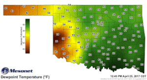
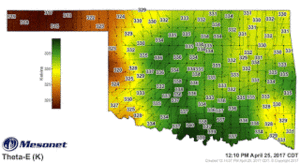
Surface
At the surface plentiful moisture is advecting northward from a Gulf with Tds in the 70s. Mid-60s already down in DFW with low 60s across southern OK. I will be watching my mesonet loops today to see how moisture changes and to see where it might start pooling.
Winds begin to back near 00z as a meso-low forms in SW Okla/NW Tx.


Upper
As SPC noted a strong 500 jet streak (60+ kts) is approaching from NM and should arrive to the target area by 00z.
The 15z RAP show 850 hPa the LLJ greater than 40 kts from the SSW by 02z resulting in 0-1km helicity of 250+ m2/s2.
Conclusion
Moisture is a big concern and capping will play a part the further south you go. But there is increased possibility of some supercells all the way down to OKC.
Special Treat
Max updraft Helicity from HRW NMMB through midnight.

12z hi-res CAM models are quite a bit more aggressive with convection developing from SE KS all the way to South OKC. 00z 3km NAM last night show some promise but this mornings models have to get you a little excited for a surprise event... IF THE MOISTURE MATERIALIZES.
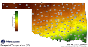
Surface
At the surface plentiful moisture is advecting northward from a Gulf with Tds in the 70s. Mid-60s already down in DFW with low 60s across southern OK. I will be watching my mesonet loops today to see how moisture changes and to see where it might start pooling.
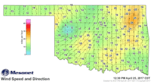
Winds begin to back near 00z as a meso-low forms in SW Okla/NW Tx.
Upper
As SPC noted a strong 500 jet streak (60+ kts) is approaching from NM and should arrive to the target area by 00z.
The 15z RAP show 850 hPa the LLJ greater than 40 kts from the SSW by 02z resulting in 0-1km helicity of 250+ m2/s2.
Conclusion
Moisture is a big concern and capping will play a part the further south you go. But there is increased possibility of some supercells all the way down to OKC.
Special Treat
Max updraft Helicity from HRW NMMB through midnight.