• While Stormtrack has discontinued its hosting of SpotterNetwork support on the forums, keep in mind that support for SpotterNetwork issues is available by emailing [email protected].

2017-04-05 REPORTS: IL/IN/KY/TN/AL/GA

Joined
Jan 14, 2011
Messages
3,535
Location
St. Louis
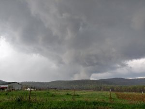
My target was the warm front as close to the surface low as clearing/heating would allow. I-64 between Mount Vernon, IL and Evansville, IN seemed to be where this was setting up, with the warm frontal zone more or less right along I-64. I incrementally moved east with each new storm moving up from the south, starting at Belle Rive and ending at Burnt Prairie. The Burnt Prairie storm had the best chance, with no upstream storms to foul its inflow. As it approached, an RFD clear slot rapidly cut in. A lowered area that looked very much like a tornado was visible, right where one would expect - but it was not clear enough to confirm, and motion did not appear to be very strong:
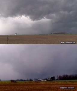
april517c.jpg

The RFD filled with precip and surged across I-64 as a strong low-level circulation appeared to be 30 seconds from producing, with tightly-rotating cloud tags and a brief rope funnel visible. I paralleled this feature on the only county road just north of I-64, but lost it as the RFD precip overtook me. A cylindrical updraft was visible above the rain as the strong RFD carved around it. I caught up to this feature again just south of Albion. The RFD winds imploded a small grain bin next to the road. Creeping north through the RFD precip, I finally broke through, but the storm quickly vanished to nothing right as it reached Albion.

With all other storms either out of reach to the northeast or behind the outflow from the Albion storm, I was out of plays, and headed home.
 
Last edited:
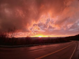
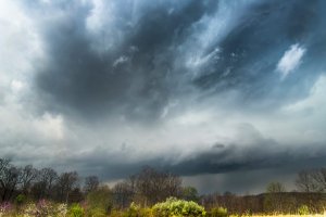
I targeted just south of Nashville, TN right on the I65 corridor as that is where the higher thetaE was nosing in. It seemed what moisture we could get was going to pool from there east and southeast. Sometime around 1930Z a few cells started going up to my south, but due to very weak ML Cape, these struggled. Further south in the more buoyant environment, a storm went up and became severe not long after. I drove down I24 to Manchester, TN to intercept and as the storm moved into a little better environment, began wrapping up and went tornado warned. As it drew near, it had a distinct lowering and nickel sized hail. I drove a little further south to get a better view and then east from there. About 4 miles east of Manchester, I saw a cone funnel but could not confirm it was on the ground. Tracking further to the east, the next couple of volume scans looked terrible, but then all of a sudden it ramped back up and as I looked up saw very strong rotation just in front of me. A terrible road network did not allow me to keep up with it, but as it got further ENE of me, I had a great visual and captured this image. At this time, I wasn't sure if it was on the ground or not, but not long after, saw reports that it was over the community of Irving College and doing damage. Other images confirmed that it was on the ground at the time. I drove further east and southeast to Dunlap, TN, but by that time, everything had turned to grunge and the terrain was terrible, so I called it a day capturing some great images of the sunset on the way back to Nashville.5a799cb7553a4bdb4a2321a67d751dea._.jpg 97e2223f0cd12c72b8dce81e5b778d23._.jpg
 
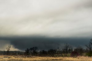
I started the day in Peoria, IL around 6:30AM where I pondered over 2 potential targets....1) the northern target along the surface low/warm front in SE IL and SW IN and 2) the dry line/pacific cold front in the south where strong tornadoes would be more likely because of greater moisture, greater instability, and good low level shear. I pondered this decision until I got down to Southern Illinois, when I noticed moisture on the northern end of this setup was going to be marginal at best. I didn't see the tornado potential up here at all despite later seeing several tornado warned storms on radar (doh!). Anyway I continued driving south until I got into Northern Tennessee by early afternoon (made great time!). I got some Subway and looked over some weather data and realized I needed to drop further south as the deeper moisture was still residing across N AL/GA into S TN. I got down to just east of Nashville off I-40 where I noted several supercells starting to take off to my southwest. I targeted the initial storm that went up near the AL/TN state-line. I got down to the storm in a timely manner, the radar presentation looked absolutely classic with a strong rotational couplet. I was surprised there wasn't already a strong tornado ongoing given the environment ahead of this thing. Anyway my first view of the storm was less than stellar because of mountainous terrain and trees just east of Manchester, TN. 3978ffb66e0da314846053a7cee4ffdf.jpg
Tornadic supercell E of Manchester, TN

I had to take a highway southeast ahead of the storm and then north toward Viola, TN because of the poor road network. I was worried about getting cut-off from the storm. When I got toward Viola, TN I found a great spot to observe the storm for a solid 5 to 10 minutes. I noted numerous staccato bolts in the vault of the supercell and a large wall cloud cresting the ridge. I expected a significant tornado at any moment here, based on its visual display and radar presentation. I saw the first occlusion totally occlude back to my SW and then the fastest hand-off I've ever seen occurred with a new wall cloud and RFD forming in literally 30 seconds. The storm formed a cone funnel that extended half to 3/4 of the way down.
cbcfdf29d7a34c77f357f8ad2b8e70eb.jpg
Large wall cloud to my SW with a funnel cloud/possible tornado in the center above the trees near Viola, TN.
I'm not entirely certain it touched down, but there was damage reports in the area of Viola, so this may have been a tornado. I had to move because the storm was getting close to my position and when I got up into town, the new mesocyclone become totally occluded and I noticed a new area just to my east, however the storm was getting into the mountains at this point. I viewed another funnel just to my east before losing it. I cored a new supercell to my NW observing quarter size hail and then headed for home.

While I got a probable tornado east of Viola, TN...this chase definitely failed to live up to expectations given the environment the storm was in. I expected a much more substantial tornado threat than what occurred. I'm thinking some of the morning storms over Northern Georgia played havoc on the environment later on in the day which retarded tornadogenesis in a lot of these storms. Regardless I was happy with how I played the day, exploring new areas to chase, and making it home by 2AM. The area of Middle/Northern TN further west actually isn't too bad for chasing, however Eastern TN is pretty awful, so i don't expect to see myself chasing here again lol.
 
I had originally set up in Corydon, IN, near Louisville, in case I was going to have a chance to pop down I-65 south for a cell on the forecast main prefrontal line of supercells. After seeing the lack of moisture on the north end of the watch area, the elevated nature of the high dew point spread Corydon, IN storm(i think I remember seeing 81/48 nearest metar), plus the clustering of the next few cells south of Louisville starting to form, combined with approaching rush hour traffic, nudged me to decide that I would move back West on I-64 towards home in Illinois where the main Low center, a couple warnings and slightly better dew points and T/Td spreads were.

A slot of clearing behind the cells along the prefrontal trough to the south had pulled up in front(east) of the low. This storm became a target when it started forming in front(east) of two Tornado warned cells along the IL/IN border coming directly off the east side of the Low pressure center. This new storm was poised to slice through the better instability(72ish/55ish) of the clear slot, then cross the warm front bulge again giving it it's best(really only) shot to produce. I hopped off I-64 at US - 231 north through Jasper figuring that the cell should approach the warm front again near Loogootee.

The storm surprisingly stuck to my math and guessing, this time, just enough to swirl a short lived EF-1 tornado(IND survey link below).

http://www.weather.gov/ind/april052017severe

 
Last edited:
Back
Top