Quincy Vagell
EF4
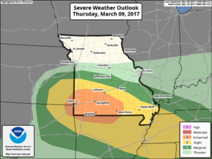
Thursday PM is gradually becoming more interesting with respect to a localized severe threat across the southeastern KS/southwestern MO/northeastern OK/northern AR vicinity.
The large scale pattern is not particularly interesting, but a wave of low pressure is modeled to develop over eastern Kansas Thursday afternoon and drop southeast into the Ozarks Thursday evening. The more conservative 12z EC and 00z GFS show a plume of modest instability, on the order of 500-1000 J/kg MLCAPE, streaming into southeastern Kansas by 00z Friday amidst mid to upper 50s dew-points and 40-50 knots of 0-6km shear. At face value, this supports at least a localized severe threat. The usually more bullish NAM brings dews into the lower 60s in the same area with CAPEs around 2000 J/kg.
Low level winds around south-southwesterly are still favorable given a vertically veering wind profile, as winds in the upper levels veer to WNW/NW Thursday evening. Forecast hodographs in the 0-3km layer become enlarged immediately ahead of the system with an increasing low level jet. A subtle vorticity wave in the progressive flow regime appears to be allowing a wave of low pressure to form along the front.
With respect to severe, the convective mode is complex, as elevated storms may form just ahead of an effective warm front Thursday afternoon, displaced from more favorable moisture to the south. A cluster of storms may ultimately initiate in the vicinity of the surface low shortly after peak heating, with a lack of large scale forcing. The 00z 4km NAM solution drops a broken line of storms into the Ozarks Thursday evening, but this may be overdone due to bloated moisture return/instability. Otherwise the shear profiles are favorable for severe, so if overnight model runs continue the trend of better moisture return, the SPC could introduce a slight risk area in upcoming day 2 convective outlook(s).
My guess is that this could, at least, be a conditionally chaseable event somewhere in eastern Kansas to western Missouri, especially if model trends continue. The NAM has been nudging north over the last few runs, but I opted to leave AR/OK in the title since this trend could stop, and/or storms may persist into Thursday night with southeast extent. If the surface low ends up stronger than progged, than the threat would become more pronounced.
Last edited:

