2016-06-22 EVENT: WI/IA/IL/IN/MI

chrisbray

EF4
Joined
Apr 24, 2012
Messages
474
Location
Bourbonnais, Illinois
Honestly guys I am shocked no one has made this yet. I assume it's the lack of care from plains residents and/or the scarcity of Midwest folks on stormtrack. I guess it falls to me...

Not much to say beyond the obvious. We have a day 2 moderate risk form the SPC across the IL/WI border area east into the MI/IN border area. I expect given decent capping and perhaps some subsidence after the morning wave/mcs moves through that there will be a window of opportunity for some supercellular storms near the surface low and along the warm front southeast. Surface low is progged by the NAM to by around the IA/WI/IL border area in late afternoon. Obviously caveats are storm mode and coverage, but we should know a lot more by the time overnight/morning activity clears out. Here are a few sample images from the 18z nam today
View media item 1167View media item 1166View media item 1165View media item 1164View media item 1163
 
I will be chasing tomorrow. Targeting the warm front/triple point, which should set up somewhere in Northwest Illinois I think. I have a feeling the warm frontal boundary might set up further south though than models are depicting. Especially if HRRR and 4km is correct on the rigor of tonight's convective activity. Its going to be a "wake up and see" type of chase day no doubt. I will say that everything looks good for something good at the onset of development, if we can keep storms at least semi-discrete for a couple hours.

This whole event gives me shades of 2015-06-22 and to an extend 2013-06-12. Not sure that means anything, but the 2015 event did end up setting up WELL south of where most guidance had it due to rigorous morning convective activity.
 
I'm 80 percent sure on heading out. It's about a 4 1/2 hour drive for me so I'm not warming up the engine yet. In the morning we'll have a better idea on the left over MCS and where the triple point is. If we could get a little clearing it will be all systems go. Even with that, a good solid hour of chasing is about all I'm expecting before it gets messy or the storms race off without me.
 
Something to keep track of for sure with the potential of strong tornadoes. Some areas in N/Central IL showing STP values = PDS TOR (+/-) 19z. It will be interesting to see what the am convection does to the rest of the day. Could see a High Risk if everything comes together at the right time over a wide area.
 
Currently targeting somewhere in a Dixon-Rochelle-Mendota, IL triangle based off NAM and assuming 4km is too aggressive with northward push of the warm front into WI. Latter would mean a shorter drive for me (have to be at work 3AM Thursday) but better chase terrain and fewer trees in IL. Not much to say other than don't see shear profiles like those progged along this WF very often in this area, but a lot still depends on what the AM round does and the cap/forcing balance. Too often I've seen what looks like a prime tornado setup have everything go up at once into an insta-derecho. High PWATs could also make for wet, ugly storms.
 
Has the looks of a raging squall line to me......if there are any discrete cells early on, it's going to become linear in a hurry. Might be an opportunity for a Tail End Charlie storm to do something interesting.
 
I'm located right in the middle of the forecast area, so I'll literally have a front row view from my home office.

Half expecting SPC to upgrade to high risk tomorrow. However, as usual for the area I think they will become somewhat linear (messy squall line) around the IL/IN border with a handful of embedded tornadoes, numerous wind reports and lots of precip.
 
Wildly different solutions by some over the CAMs overnight compared to more current RAP/HRRR runs.

Most of the NSSL models have discrete storm or bowing clusters initiating late afternoon around the quad cities and tracking southeast, while one of them has one cell pop along the warm front in eastern Illinois (tracking over my home county). HRRR has supercells in far north central IL south of the WI border, and it doesn't even really show much backing of winds ahead of the low/along the WF. RAP has a much more southerly combo of the shear/instability that the others...
 
HRRR showing a pretty scary scenario...pair of long-tracked supercells just south of ORD. and pretty late too, darkness may be problematic.
 
Made the call about 9:00 am to bail on chasing today. It seems like every potential big day up this way gets it's butt kicked from leftover convection. I work at 6:30 tomorrow morning. Getting home after midnight for nothing would have felt as good as burying rocks so I would have something to dig up the day. Ugh!
 
Andy Wehrle was all over his target area prediction...that was spot on. I started at Rochelle and saw a few funnels but was always re-positioning it seems when tornadoes were reported. A lot were pretty rain wrapped most of the time so without the right vantage point, you weren't seeing it.
 
Andy Wehrle was all over his target area prediction...that was spot on. I started at Rochelle and saw a few funnels but was always re-positioning it seems when tornadoes were reported. A lot were pretty rain wrapped most of the time so without the right vantage point, you weren't seeing it.

Thanks! My group was sitting in Morrison and jumped on the supercell that was beginning to mature to our south, near Prophetstown. We got a good look at the photogenic wall cloud with the first cycle near Tampico but likewise never got a good look at the funnels and tornadoes that were later reported near Manlius and La Moille, while the next cell to the east turned out to be the most prolific tornado-wise.
 
Sounds like we were on the same one then. I had a fork in the road and could go east to that cell that was the most prolific and also buried in rain or go straight and head south at the La Moille one...choosing the latter was picturesque for a bit but later difficult to keep up with.
 
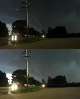
I finally have some time to go through Wednesday's imagery and video in detail. I believe I saw the rope/narrow cone tornado at Troy Grove, but my contrast was poor. The possible tornado in my video is quickly moving north. I saw it at the time with my eyes, but contrast was not sufficient to call it. Can anyone who was there confirm if this small tornado was moving north?

This is in Troy Grove looking west. The tornado, if this is it, would be west of town close to Highway 52. The bottom image is contrast enhanced.

june22g.jpg
 
Back
Top