Greg R
EF0
After seeing the storms fire near the central OK/KS border I quickly headed towards Udall, KS to get ahead of the leading cell. A few times I saw lowerings with mild rotation on the southernmost part of storms but it never became tornado warned. Around 3:30p two cells were going to merge so I stuck it out to see what would happen.
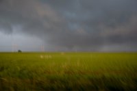
Not much happened when the shelf clouds collided but not too long after I saw some stronger rotation on radar. Low and behold I looked over while driving and saw a very brief tornado (maybe on the ground for 15secs). This was south of Leon, KS. My picture of it craptacular and out of focus but that's what happens when I had to quickly stop the car to snap a shot. It was gone before I could set my aperture and re-focus. But we had a tornado here.
Ah, a fun day.
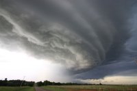
Merging Cells...
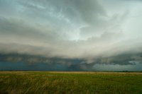
And the Craptacular Out-of-Focus Shot (But at least you see what I saw!)...

Not much happened when the shelf clouds collided but not too long after I saw some stronger rotation on radar. Low and behold I looked over while driving and saw a very brief tornado (maybe on the ground for 15secs). This was south of Leon, KS. My picture of it craptacular and out of focus but that's what happens when I had to quickly stop the car to snap a shot. It was gone before I could set my aperture and re-focus. But we had a tornado here.
Ah, a fun day.
Merging Cells...

And the Craptacular Out-of-Focus Shot (But at least you see what I saw!)...
