2016-05-09 Event: OK/KS/MO/AR/TX/LA

Trey Thee

EF2
Joined
Mar 29, 2010
Messages
191
Location
Tulsa metro
A potent severe weather setup appears in place for tomorrow. Right now I tend to think the enhanced risk may be moved slightly back to the west, perhaps right along the I35 corridor instead of just to the east.

OK - Wind profiles seem adequate to support supercell storms with all modes of severe weather. There is some backing winds showing up on a couple of the models but it is relatively minor. Low level moisture will also be adequate. Mid 60s dew points and moisture depth being better than today we could see a substantial tornado threat develop just off the dry line back to the OK/ARK border.

The 4k NAM is decidedly more aggressive with moisture return over the NAM and GFS so I'd disregard the moisture on the latest 4k. But wind profiles which it seems to generally do better at forecasting become decidedly more backed at the surface after 7pm. Composite reflectivity on both the NAM and 4k indicate storms breaking out off the dry line and pushing into the Tulsa area between 7 and 8pm. Simultaneously the above mentioned surface winds become more conducive to tornadic development.

In Arkansas it appears initiation could begin by 5 pm. Again some backing occurs at roughly 600mb to 500mb but it's minor as indicated at this point. Storm relative helicity looks ample over Arkansas as well. The overall environment in Arkansas may prove to be the most dynamic, especially from 7pm to midnight. Nocturnal tornadoes seem possible with this setup.

The sight risk extends well north of Kansas City, it includes Omaha and SW Iowa. North east Texas falls under the enhanced risk and an isolated cell that could get going in NE Texas will have better moisture to work with.

I would target the dry line in Oklahoma, I40 up to the KS border or west central Arkansas tomorrow.
 
Outflow boundary on the Red River is retreating north along and west of I-35, as of Noon. The sun is back out on both sides of the dry line. I would target the dry line outflow boundary intersection currently progged to be in central Oklahoma late this afternoon. I might believe the hi-res guidance with cell(s) going later in central Oklahoma if on that outflow. Probably start immediately east of OKC to avoid traffic.

Warm front and locally backed surface wind will be in south-central Kansas, but I question enough airmass recovery there. Also wind fields are weaker at all levels in Kansas. The rest below is for Oklahoma.

Upper level wind fields will be tricky as the morning short-wave exits and new energy comes in from the west. Midday VBV and 700 mb weakness is progged to improve by late afternoon. Low level wind speeds should increase just in time late this afternoon as the new short-wave comes in. I would not count on cyclical supercell(s) today. However a tornado or two is possible. As most know the terrain is questionable east of I-35 so be careful.
Certainly seems that the tor threat will be somewhat mitigated by the airmass being overturned significantly in SE Oklahoma. I think you have to go to the Red River or even into TX for sustained early cells. I wouldn't be surprised to see something get going along the dryline N of I35 but the threat seems fairly low at this point. I think NE Texas and into western and central ARK we could see a more significant risk of SVR weather.

Large hail certainly seems like biggest threat for most of eastern OK.

The setup isn't looking great though, ultimately glad I don't have to think about where to chase today. I like the Shawnee area or all the way over to Ft Smith waiting for something to go up in Ark.
 
Outflow did not make that much progress north. HRRR and others picked up on the south-central OK cell a few runs back but I did not post. Figured people would track the outflow on their own. At any rate, you are right the best chance is southern OK. Pauls Valley and Wynnewood confirmed tornadoes; wow, I did not expect cyclical.
 
Last edited:
Jeff... I think that outflow boundary was one of the main culprits for the quickly developed tornado near wynnewood area. That storm went ballistic when it sucked in that OFB. Also of not, the Norman storm sucked up and OFB and that was about the time it went tornadic. Lots of OFBs today. On a side note... i was watching the Moore storm from Andi Alligators. Stayed about 2 minutes too much as i got hit with lots of dime size hail before i could get home and in the garage.
 
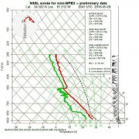
Incredibly impressive environment sampled by the NSSL before the tornadoes formed. 4584b03d39951c178e97b928d5f5073b.jpg

Sent from my XT1080 using Stormtrack mobile app
 
May 9, 2016 is whey a chaser should never give up. State of the art of the science still cannot pick out the day during a sequence. Sounding above over performed every forecast I saw. That said high resolution guidance as done well the entire sequence. It got Colorado Saturday. It never promised a gold mine Sunday. By early afternoon it had the right cell placement Monday.

Pattern recognition said go to the outflow, which worked out very well. However I was saying, look for a couple tornadoes no real cyclical show. Wow, was I wrong! Sunday storms struggled with brief shows. Monday the jet stream was much more veered, eliminating many problems of the prior days. Still the human in me doubted based on the recent past.

Over the weekend storms that did tornado were on outflow boundaries. Since the shows were brief (outside of Colorado) I carried that bias into Monday. Still one has to try each chase day. Note that I have not taken my chase trip yet, but I would have chased every day this sequence.

We often talk about storms riding a west-east boundary. Monday was a little different. Boundary was retreating with the storm on it. Boundary was more northwest to southeast, almost NNW/SSE. Monday reminded me of Rozel 2013 and Harper 2004 etc. Storm motion and boundary retreat must sync. I think the storm has some influence when it creates its own environment. Since one cannot always pick out the day, one must keep trying.
 
It has been my experience that OFBs like what we had yesterday are notorious "tornado race tracks" when you get a storm to ride the boundary. Clearly we did not have VBV during this event. The shear profiles were already good enough for supercells, and the OFBs really enhanced the low-levels. Something I noticed yesterday was on the surface analysis you could see a hard dry punch across southwest OK aimed right at Duncan/Pauls Valley area. You had the OFB intersecting the dryline with locally enhanced backed surface flow. Dewpoints jumped from the 30's just west of the dryline to mid/upper 60's to low 70's a county or two east. I remember thinking how that dry punch looked like something we saw on May 19, 2013. It makes sense that we saw a high-end tornado event when considering the environment we ended up with.
 
After analysing all the models & the physical charts, selected Durant, OK ... arrived there well in time to see initiation to the west & southwest ... was feeling a little smug, unfortunately as it turned out, as the SPC issued a tornado watch, with us smack in the middle of the western 1/2 of the watch box ... felt that with predicted storm motion, we were perfectly positioned with this convection ... watched on GRLevel3 as a number of chasers bailed from their initial positions north of I40 ... then a storm kicked off west of Wynnewood, soon intensified rapidly, and you know the rest - it produced a set of superb chaseable photogenic tornadoes, unfortunately causing two fatalities ... couldn't help feel that some of the chasers coming south were extremely fortuitous to be coming by as this storm blew up ... looked at it on radar, but the hour & 40 minute drive north seemed to rule it out, lifecycle-wise, given we had all this developing convection on our doorstep, in a "bullseye" of severe parameters.

Having said that, many reputable long-term chasers seemed to have been perfectly positioned for this storm. Someone suggested that the storm ingested/interacted with a random outflow boundary, which caused it to "go nuts".

In pursuit of improving the "craft" what factor/element that morning caused many of you to select that spot? What did I miss in that morning's analysis of the models, forecasts, surface charts & visible satellite?

Or were you many of you just "lucky"? ;-)

We saw all sorts of tornado-warned storms, great structure, giant hail, wall clouds, lightning, sunset lighting effects etc that day - so was a great chasing day ... but we did miss the "big one" which was frustrating.

Would anyone like to offer their expertise on what happened?


Sent from my iPhone using Stormtrack mobile app
 
Having said that, many reputable long-term chasers seemed to have been perfectly positioned for this storm. Someone suggested that the storm ingested/interacted with a random outflow boundary, which caused it to "go nuts".

In pursuit of improving the "craft" what factor/element that morning caused many of you to select that spot? What did I miss in that morning's analysis of the models, forecasts, surface charts & visible satellite?

Or were you many of you just "lucky"? ;-)

We saw all sorts of tornado-warned storms, great structure, giant hail, wall clouds, lightning, sunset lighting effects etc that day - so was a great chasing day ... but we did miss the "big one" which was frustrating.

Would anyone like to offer their expertise on what happened?

Extremely fortuitous boundary placement from prior convection coupled with the unexpectedly great low-level shear along a sharpening dryline is what caused that big kahuna. Very few people, at least from what I saw, were expecting what the Wynnewood storm did simply due to the previous observations from the day showing extraordinarily meh shear profiles (12Z OUN sounding had a particularly nasty straight-line hodo). The only real indicator we got as we were rolling out the door was the NSSL sounding I posted above. Just building off of my own thought process, we were already moving south and were maybe about 25 minutes from Wynnewood when it began producing so it was partially luck that we were within striking distance and got through the FFD relatively unscathed but the only shred of anecdotal advice I can really offer is always watch for boundaries on days with initially meager shear.
 
Back
Top