• While Stormtrack has discontinued its hosting of SpotterNetwork support on the forums, keep in mind that support for SpotterNetwork issues is available by emailing [email protected].

2016-04-29 REPORTS: OK/TX

sdienst

EF2
Joined
Sep 25, 2006
Messages
102
Location
Friendswood, TX
Not much to report on here, but I was on the Ninnekah, OK supercell like many others. For some reason I decided to go north out of Rush Springs to try to get a "view". Got slammed with probably 90mph winds at one point and had some sheet metal flying across road behind me. Continued north after it crossed road and there was some scattered debris and downed power lines about 1/2 mile north of where I rode things out.


I chased Southwest into Central Oklahoma this day targetting the warm front/dry line intersection near Lawton. I got on the storm of the day that eventually interacted with the surface warm front N of Lawton and moved east producing tornadoes outside of Chickasha, Oklahoma (near Ninnekah). I observed a multiple-vortex tornado in this area around 4:05PM from a distance of ~2-3 miles before it got completely wrapped in rain and moved northeast. I encountered golf ball size hail and ~70 mph winds in the RFD of this supercell before I finally got ahead of it again near Maysville, Oklahoma. I noted at this point the storm had gone largely outflow dominant and called the chase off and started heading towards Wichita, KS for the night (on the way back to Illinois). Overall a very satisfying chase day considering what we had to work with and to get a *good* view of the tornado on such a high precipitation storm. Here are some digital stills that I shot during the chase:

36fdab8a9739c927a65a921f26908553.jpg
Supercell structure west of I-44 before tornado-genesis

e77b31094f088846f3642a3439b2a49f.jpg
Supercell on I-44 just moments before tornado-genesis of Ninnekah, OK tornado

6862cf7c49e4cd7d7cd03883a9e363be.jpg

3ef4fb6cee007533f6fc56f9c5d7088f.jpg

6364c6fa93cd8fcb095625e8ce9956db.jpg

868f411feeaaead20a4d8101dc6ab5f6.jpg

I possibly got a view of the tornado before this near Fletcher, OK, however rain-wrapping around the mesocyclone made my confirmation of this difficult to impossible, so I've just included the photos that I know for sure of :) Its a shame this thing wrapped up in rain after this, because I'm certain it grew into something quite large, just not extremely visible (given the intense couplet that was visible on KTLX radar at the time).
 
I woke up this day at a service area along I44 near Chickasha, Oklahoma....... I should not have even moved. I left that area and headed for my original target which was just south of Lawton, near the OK/TX border. I waited there for a few hours and kept watching developing cells about 45 minutes west of me, heading towards the Tipton/Snyder areas. I really didn't want to go after this stuff because you could see it was clearly behind some sort of boundary. It became evident though, that those cells were going to be the show of the day, and potentially ride the warm front and get something done. I blasted west towards Tipton and got onto the initial storm (the storm that would become the landcane)... As I was on this storm, I saw that it was being rained into by a developing storm to its south. I decided to go for the tail end storm because the updraft base was looking good and I thought the northern storm would likely cross the WF and become elevated. Turns out the northern storm rode the warm front, and produced the rain wrapped tornadoes, while my storm stayed behind the boundary and got undercut the entire afternoon. Not to mention it kept getting flanked over and over by new convection to its south.... So annoying. Whales mouth city. I did catch some rising dust into a developing wall cloud early in my tail end storms life cycle, as well as some nice scud rising and rotating into the base before again getting flanked and undercut. Overall, I am very annoyed that I chose the southern storm, but then again, I don't really care about missing a rain wrapped spin up on I44 in populated areas. Likely a very stressful situation up there with not much reward.

ee7893316d9bc83326739c01e67d1be6.jpg

757bf8c094b6891e286336b221fde780.jpg

96b6c81eca3ac216f52a772aea3056ab.jpg


Sent from my iPhone using Stormtrack mobile app
 

Attachments

  • 9a74b30a8ae54b270a60c0804a05830c.jpg
    9a74b30a8ae54b270a60c0804a05830c.jpg
    174.3 KB · Views: 78
Last edited:
In the morning I made my target area forecast and my initial target was the Wise, Denton, and Collin county TX areas with initiation between 1 and 2 PM. I picked this area because it had a little better low level shear than some other areas and it’s in my own backyard. I went to work because I had to get some things done and didn’t want to take more vacation time after taking Tuesday off to chase. I decide I would leave at 2, and just before then storms started to fire and passed over my office near the Collin and Dallas county borders. It was just rain, but it picked up some strength as it crossed into Collin County. I went east on the George Bush Turnpike and saw some very broad rotation to the storm, but that was about it. I chased it up 78 until it began to weaken. I drove home and tried to get a few things done while keeping an eye on the radar. I started to notice some cells starting to fire again so I called my chase partner and told him we had to get going. We drove up Preston Road and stopped in Prosper just before the storm became severe warned at 4:45. A few minutes later we noticed a strong updraft to our west sucking scud up. It formed a wall cloud and started to rotate and we reported it to the Skywarn net. At the same time the cell to our north in Grayson County became tornado warned (it never confirmed). We let the updraft pass just to our south and we got a little rain and then we followed it east where we saw a little more rotation around Weston.

The funny thing about this is while we were sitting in Prosper watching the rotating wall cloud to our west, a confirmed EF-0 tornado touched down in Celina a few miles to our north from 4:53 to 4:54 PM. We never saw it, as we only saw rain to our north. We didn’t see rotation on radar either. Neither did NWS, as they didn’t issue a tornado warning either.
 
Summary: frustrated by slow traffic in south-central Oklahoma and stuck just ahead of or in the precip core of what was basically a squall line.

I met up with Jeff Snyder at the National Weather Center. We left Norman around 10:30 AM with an initial target of Wichita Falls. The warm front lifted gradually, although sometimes in jumps, as we made our way southwest on I-44. It wasn't until we were within a few miles of the river that the sky really opened up, indicating our transect. It was pretty damn soupy on the south side of the front. Obs were in the neighborhood of 81/70.

We lunched near I-44/U.S. 287, then headed up 287 as convection slowly initiated in far southwest Oklahoma. One storm became somewhat dominant as it passed through Altus, and we turned up U.S. 183 towards Frederick/Snyder to get in front of it. We never made it all the way to that storm, as new development occurred to its south as we were approaching Manitou.

The scenario was a little puzzling as we moved north from Frederick. As we approached the storm, it became apparent that it was having trouble getting ahead of a boundary. We didn't think it was the cold front, but the storm never made any progress getting ahead of it, and was restricted to behind the boundary the whole time. This behavior manifest as a shelfy whale's mouth appearance to the front of the storm. There were numerous dusty spin-ups along the gust front as we moved north on 183, all gustnadoes, none particularly photogenic.

It became apparent how outflow-dominant this storm was as we went east on Baseline Rd. east of Manitou. We had to get at least 10 miles ahead of the precip core to stay in the juicy air east of the outflow. Not only that, but cloud bases were rather high for 10 F dewpoint depressions. As Jeff later commented, it seems likely that this storm was not truly surface-based. There must've been a parcel source level above the surface that had less CIN than the surface parcel. This evolution is consistent with there being no warm sector convection in Oklahoma west of I-35.

As we approached Lawton, the original storm, still well north of us, started to attain a more traditional supercell shape, and rotation developed and intensified. We decided we would ditch our current crapvection and try to get ahead of that storm, but it was fast approaching I-44 and we were going to have to make a decision about what to do to avoid getting stuck in blinding rain and large hail or driving into a tornado with no escape route (the H.E. Bailey Turnpike has very few exits between Lawton and Chickasha). We decided to jump off I-44 at a side road that went east from Lawton, not expecting traffic to be an issue. First problem: we couldn't find the exit. A few of the exits on the north side of Lawton are for Fort Sill only, and we missed the one we wanted the first time around. So we lost time there. Then, when we finally got off where we wanted to, it was 3:30 on a Friday in Lawton, and it seemed like every single resident was out and about, even as far east in town as we were. Perhaps they were freaking out about the looming storm which did end up dropping giant hail on parts of Lawton. Also, my map deceived me. I thought we would have a clean east road for miles all the way to OK-65. Wrong. Our road turned south without giving us a choice to stay east. Apparently the road I thought we wanted was just inside the boundary of Fort Sill. So that mistake slowed us even more.

Finally we reached OK-65 as reports of tornadoes near Elgin and Fletcher were starting to roll in. We needed to get north in a hurry. Unfortunately, as we approached Sterling, we started getting stuck behind traffic driving slower than the speed limit. The core caught us as we arrived in Sterling. We had no choice at that point but to turn east on OK-17 and hope we could get to U.S. 81 and north in time to get back ahead of the supercell. Doppler velocities on that storm looked nasty at that time, and it was obvious we were dealing with an HP storm (it probably only produced because it finally latched onto the lifting warm front). Even so, we still had a narrow berth to get ahead of it.

Not if Oklahoma traffic had anything to say about it. We couldn't manage more than 45-55 mph eastward and essentially made no progress on the leading edge of the heavy precip. We just barely started to poke out ahead of it as we approached the U.S. 81 intersection. By that time, we had just a few minutes to get north at least 8-10 miles, and the cars that were slowing us down were also turning left. I convinced Jeff to abandon hope on that storm and turn back south, towards the yet undisturbed air ahead of the squall line.

We tried blasting south on 81. For segments where it was four lanes, we were able to make good time. But we had to go through Marlow, which was bigger than I remember, and south of there and on the Duncan bypass it was two lanes, and we almost always had a slow driver in front of us. In fact, south of Duncan we had to follow some idiot with a Texas license plate driving no more than 45 mph, even though it was raining heavily. He seemed to have no interest in making quick passage southward. When we finally got by him near Commanche, we saw he was holding his phone camera in front of him, apparently recording his drive through heavy rain. Alright...

We had basically fallen behind the core by the time we reached Commanche. The line was pretty thin at that point, and there was little remaining hope of anything organizing on the south end of the line even though it remained open. We finally got back ahead of the rain going east on OK-53. Around Loco, we pulled off to watch the shelf cloud catch us once again. It revealed a rather pretty looking cloud texture within the whale's mouth, but we were both frustrated, and didn't care much to photograph it (Jeff snapped a few photos, but I didn't). We "officially" called the chase there and made our way back to I-35, happening to clip an embedded core with torrential rain and some small hail as we turned north on I-35 at the Davis interchange.

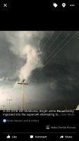
Picture of the only decent looking wall cloud anything south of the one tornadic storm ever put out. It had impressive vertical motion on it's right side for a few minutes before fizzling out. Never exhibited any obvious rotation.
late_April_2016_120-1.jpg
 
Last edited:
Completely blanked on this day after the decent May and forgot to add my own log.

Started out of Norman in the early afternoon with storms going up along the dryline just west of the Wichitas. Moved down 44 as the main supercell of the day began to take shape near Saddle Mountain. Initially we were looking to stay east of Fletcher and let it come to us but with how quickly it's low-level circulation ticked up, we instead moved into position to look down the notch west of Fletcher on the east side of Lake Ellsworth. Got our first view of the storm as it was rotating like a top and rapidly turning HP at this point. Had a pretty well defined RFD cut with a solid updraft base/visible rotation. Also displayed the most eerie green glow I've probably seen outside of the Elmer storm.

ec990ed07414220061a9ccf00c7cdf67.jpg

After encountering a confused local in an old VW bug, we hauled it back east through Fletcher and over 44 before cutting north again. Most features were not discernible from our vantage point until we got east of Cement on US 277 after popping out on Country Street 2730. The storm was pulling in inflow like crazy by this point and already had turned it into an almost as dark as night lighting situation. As a result, none of my photos of the ensuing multi-vortex tornado came out well as we closed in on Ninnekah (also partly due to my lack of a tripod in strong inflow winds). Andrew Lyons managed to grab the following photo in the distance of the tornado as it touched down.

0fe256f6cb5f63476cafba02d9756011.jpg

Shortly after watching it move back into the rain, we continued east on US 277. The storm's massive gust front was rapidly approaching and the tornado was completely shrouded by the time we reached the Ninnekah Truck Stop. At this point, we got slammed by high winds and heavy rain/small hail. We continued east/southeast into a worsening road grid due to the numerous creeks/streams that feed into the Canadian River to the east. We gave up the ghost near Dibbler and headed back to Highway 9 with the storm on our heels. We rode it out as it entered Norman near Riverwind Casino as it continued to choke itself off.

Definitely not the spectacular first tornado of the season I had been hoping for after the initial frustrations of April, but a decent chase nonetheless, even with the crappy terrain and worse road options.
 
Back
Top