An interesting way to start of the chase season. I really thought that the big action was going to be in northern Mississippi to western Tennessee, but it didn't play out that way.
I was in New Orleans for dinner on Monday night and wanted to get to a hotel and keep the southeastern target (near AL/MS) in play, so in addition to wanting to have time to conduct a severe weather briefing, I set up shop near Jackson, MS that night. (The original thinking was to get closer to the TN border, but I opted not to)
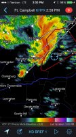
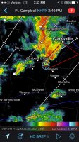
In the morning, I was in no rush to leave, as some of the high resolution guidance (mainly HRRR) was showing a long-tracking cell developing near JAN and moving off to the northeast. I believe that was the junky string of line segments that prompted tornado warnings up into the Starkville area. I was on these storms for a while and was all set to bail north, but it didn't feel right. Seeing a richer warm sector to the southeast and more sharply backed winds, I started diving southeast. It wasn't long before a couple of cells between Hickory and Philadelphia, MS caught my eye.
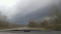
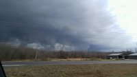
I headed down US-45, barely staying ahead of the northern cell. It was the southern cell that was looking the most prominent, so I cut over into AL and dropped down AL-17. Once near Geiger, the visibility was terrible due to trees, so I turned toward Scooba. I had a glimpse of what was probably a tornado, but I decided to get back onto AL-17 and head north for an intercept. Once coming to a point near Panola, I finally had a clearing to the west and had views of a strong tornado in progress. The tornado headed toward Memphis and I paralleled it up AL-17, all the way to just north of Reform. By Aliceville, it was really too rain-wrapped to see from my vantage point. I attempted to take some back roads to avoid getting caught up in the circulation, since AL-17 was turning right into the storm's path, but trees were down everywhere and I called the chase off. It was dark by this time anyway and I felt pretty accomplished for the chase.
After seeing the NWS surveys, it looks like there were two separate damage paths, as the initial tornado near Scooba lifted shortly before the AL border. Just as the storm crossed over, it touched down again and left a swath of damage into the Carrollton area. Two tornadoes in two states on the first chase of 2016, in February, not bad at all.
The footage above are some rough cuts I rushed to put together Tuesday night. I was testing out a new "1080p HD" waterproof camera, but the footage looks very mushy and more like 720p or even 480p. I had an HD panoramic camera on the roof, but that was riddled with raindrops, also leaving the video at a lower quality than I would have hoped for. I guess I can't complain too much that I was able to chase the storm at all, given the road network and tree issues.
For shorter attention spans, a 14 second clip.
It was a birthday "chasecation" of sorts, with my birthday being on Wednesday. I think Mother Nature gave me a very appropriate present. The original plan was to go to Florida for a vacation, but with the severe weather potential, I split up a road trip into several smaller stops (FL Panhandle on Sunday, Gulf Coast/New Orleans Monday, chasing Tuesday and Nashville/Tennessee on Wednesday).
As far as models go, the HRRR struggled significantly. The 4km NAM picked up on the idea of discrete cells in the warm sector near the AL/MS border from about 60 hours out, even if the timing was a little off. This was another example of why meteorology often trumps modelology when chasing.
Here is a quick Vine video I had of the likely tornado over Scooba:
https://vine.co/v/iJMe5PUO5KT
Damage 4 ESE Kennedy that signaled the end of my chase:
https://vine.co/v/iJOB7e9KIt6
Time to dust the cobwebs off and gear up for the next chase!