Danny Neal
EF5
Date: August 18th, 2015
Location: Abingdon, Channahon, Romeoville
Event: Several Supercells
Summary:
Decided to pull the trigger and chase a marginal day here across Northern Illinois. For the better part of the year I have been at the NWS office for bigger events, so this was a nice break to get back out in the field. Adam, Ricky Castro from NWS LOT, and I decided that Western Illinois saw the best potential for supercells and subsequently ventured out that way just after noon. We made Galesburg by 3 P.M. and started stair stepping storms. A few showed supercellular characteristics [shown below], but due to no surface flow were not able to maintain a favorable balance. The storms out west were not as HP as I thought they would be, but couldn't establish any inflow. Most of Northern Illinois was under a tornado watch, including our home areas in the Chicago metro. We noticed storms developing near the vicinity of the outflow boundary and made the decision to blast back east toward the I-55 corridor. As we neared Peoria, tornado warnings were issued for the Pontiac area and a few tornadoes were eventually reported and documented. We pressed on east toward Pontiac, but were several minutes too late for the show. To our west a rapidly evolving QLCS was setting it's sights for our location. We were going to sit in Odell and let the line overtake us, but some renewed rotation developed just south of Morris and we set off for it. As we approached the storm had a few suspicious lowerings that a couple of people have tried to argue was a brief tornado. We were too far out of position to view it, so couldn't help that argument. As we moved into Morris, the rotation was located over the city, but a new area was forming off to our east near I-55. We took Route 6 out of Morris and core punched the storm until we came into Channahon. At this point we noted beautiful supercell structure and even some broad rotation hovering near the Route 6/I 55 intersection. The storm started to get very well developed at the lower levels and exhibited excellent presentation on the radar. At this point we were basically in constant contact with the NWS as the storm was heading straight for the office. Not only was it headed for the office, it was headed toward my house. As the storm got east of 55 and north of 80, a tornado warning was issued. Sirens wailed as we blasted north of Larkin/Weber Road. A dramatic clear slot carved it's way around the updraft and we thought a big tornado was about to descend over my neighborhood. As we crossed Caton Farm, a big bowl lowering crossed the road a mile or two ahead of us and dropped. Here we go, big tornado about to form directly near the NWS office. We stopped at Division and Weber and watched as this strongly rotating wall cloud churned over the neighborhoods on Renwick Road. Adam did a live update, Ricky was on the phone with the NWS, and I was giving a play by play. Thankfully the RFD wrapped around and choked off the storms inflow and the rotation began to weaken. I know it is odd for me to be thankful for not witnessing a tornado, but when it is directly over my house I think I am excused! The storm moved deeper into the city and we decided to head back to my house and let the QLCS run us over. It was largely unimpressive, but did have a few embedded circulations that ended up producing a few weak tornadoes in Bolingbrook/Naperville/Downers Grove area. The metro area dodges another bullet.
Photos/Video:
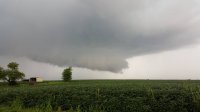
Wall cloud with broad rotation near Abingdon.
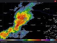
Rotating supercell approaching the Abingdon area.
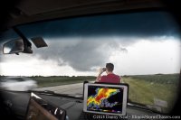
Storm looking less organized visually, but still a great radar presentation.
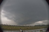
Storm entering Channahon exhibiting beautiful structure with rotation.
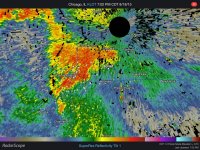
Beautiful radar presentation as well as the storm heads for the southwest metro.
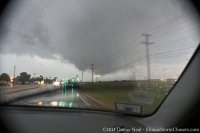
Large bowl lowering passing over Weber Road near Division in Crest Hill
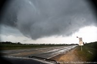
As close as it came to producing a big tornado, very strong rotation over the NWS office.
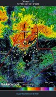
Supercell directly over the radar.
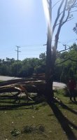
Damage in Naperville from tornado.
Location: Abingdon, Channahon, Romeoville
Event: Several Supercells
Summary:
Decided to pull the trigger and chase a marginal day here across Northern Illinois. For the better part of the year I have been at the NWS office for bigger events, so this was a nice break to get back out in the field. Adam, Ricky Castro from NWS LOT, and I decided that Western Illinois saw the best potential for supercells and subsequently ventured out that way just after noon. We made Galesburg by 3 P.M. and started stair stepping storms. A few showed supercellular characteristics [shown below], but due to no surface flow were not able to maintain a favorable balance. The storms out west were not as HP as I thought they would be, but couldn't establish any inflow. Most of Northern Illinois was under a tornado watch, including our home areas in the Chicago metro. We noticed storms developing near the vicinity of the outflow boundary and made the decision to blast back east toward the I-55 corridor. As we neared Peoria, tornado warnings were issued for the Pontiac area and a few tornadoes were eventually reported and documented. We pressed on east toward Pontiac, but were several minutes too late for the show. To our west a rapidly evolving QLCS was setting it's sights for our location. We were going to sit in Odell and let the line overtake us, but some renewed rotation developed just south of Morris and we set off for it. As we approached the storm had a few suspicious lowerings that a couple of people have tried to argue was a brief tornado. We were too far out of position to view it, so couldn't help that argument. As we moved into Morris, the rotation was located over the city, but a new area was forming off to our east near I-55. We took Route 6 out of Morris and core punched the storm until we came into Channahon. At this point we noted beautiful supercell structure and even some broad rotation hovering near the Route 6/I 55 intersection. The storm started to get very well developed at the lower levels and exhibited excellent presentation on the radar. At this point we were basically in constant contact with the NWS as the storm was heading straight for the office. Not only was it headed for the office, it was headed toward my house. As the storm got east of 55 and north of 80, a tornado warning was issued. Sirens wailed as we blasted north of Larkin/Weber Road. A dramatic clear slot carved it's way around the updraft and we thought a big tornado was about to descend over my neighborhood. As we crossed Caton Farm, a big bowl lowering crossed the road a mile or two ahead of us and dropped. Here we go, big tornado about to form directly near the NWS office. We stopped at Division and Weber and watched as this strongly rotating wall cloud churned over the neighborhoods on Renwick Road. Adam did a live update, Ricky was on the phone with the NWS, and I was giving a play by play. Thankfully the RFD wrapped around and choked off the storms inflow and the rotation began to weaken. I know it is odd for me to be thankful for not witnessing a tornado, but when it is directly over my house I think I am excused! The storm moved deeper into the city and we decided to head back to my house and let the QLCS run us over. It was largely unimpressive, but did have a few embedded circulations that ended up producing a few weak tornadoes in Bolingbrook/Naperville/Downers Grove area. The metro area dodges another bullet.
Photos/Video:

Wall cloud with broad rotation near Abingdon.

Rotating supercell approaching the Abingdon area.

Storm looking less organized visually, but still a great radar presentation.

Storm entering Channahon exhibiting beautiful structure with rotation.

Beautiful radar presentation as well as the storm heads for the southwest metro.

Large bowl lowering passing over Weber Road near Division in Crest Hill

As close as it came to producing a big tornado, very strong rotation over the NWS office.

Supercell directly over the radar.

Damage in Naperville from tornado.
