• While Stormtrack has discontinued its hosting of SpotterNetwork support on the forums, keep in mind that support for SpotterNetwork issues is available by emailing [email protected].

2015-06-02 REPORTS: ND,SD,NE

Mike Marz

EF3
Joined
Mar 11, 2014
Messages
209
Location
Minneapolis, Minnesota
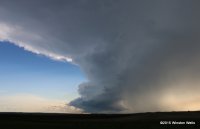
I left work at 10 am on this day and headed west from Minneapolis towards the Dakotas. As I neared the border of South Dakota, there was a gorgeous storm on radar already in progress in south central North Dakota. I headed west of Aberdeen towards Eureka making good time getting to that cell, but by the time I was within 10 miles of it, it completely evaporated. It was extremely frustrating, but also very fascinating to see just how fragile things can be sometimes. The rock hard updraft, looking good just 20 minutes earlier, was nothing but convective debris now. It reminded me of April 8th earlier this year with the supercell near Seiling, Oklahoma. I began heading east thinking the day was done, but I noticed a growing cumulus field to my north and headed that way. A pretty benign looking tower with just a small rain shaft proceeded to split and then about a half an hour later the right split exploded into the sky. I don't think I have ever seen convection bubbling up into the sky that fast without a time-lapse. That was impressive to see. I was pulled off on the shoulder looking straight up into the updraft when a massive whack sound struck behind me. Something shattered my windshield. It was a big spider web looking thing, but I decided to keep chasing. Sadly with every bump I hit in the road the window got worse until eventually it all just collapsed into my back seat. It was very odd, I was not in the hail core and I am not sure how large the hail being reported with this storm got, but a random stone must have come flying out of that updraft somehow because my back window is now gone... Eventually the storm got a bit organized in the low levels and gave a few attempts at wall clouds and rising scud into the base. At one point the scud type looking clouds were rotating pretty good and becoming less ragged and more funnel like, I was almost positive I had a funnel, but I am not sure it was truly a funnel. It did not persist for very long. Overall though, a decent chase.
8476-bc4e3a257a79f1f584a1b931741a0e2f.jpg

full

8478-5cf4b35a4a6132eb8384133030d6aecd.jpg

8479-c996140ad25c99edabb457627888ffe0.jpg

11406409_10101431120844371_8312397296778421733_n.jpg
 
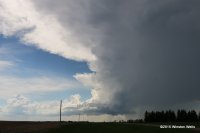
I also chased south-central North Dakota and caught a great LP supercell as it drifted slowly to the southeast above the Missouri River near Linton and Strasburg, ND. After overnighting in Sioux Falls, I considered three targets: the northwest Nebraska panhandle, central South Dakota near Pierre, and the James River valley in North Dakota. I opted for the latter and headed north on I-29. After having lunch in Aberdeen, SD, a cell began to fire well off to my northwest over Strasburg, ND. An MD and red box soon followed, so off I went. Here's what the cell looked like as I approached it from the east on ND-11. This shot looks west from about twenty miles east of Hague, ND:

IMG_2793.JPG

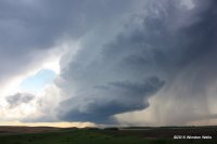
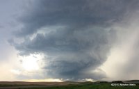
Although it was SVR-warned, it collapsed quickly as I approached, leaving only an orphaned anvil that floated by to my north. I then went into the small town of Hague and waited for another storm that had fired well west of Bismarck - and had briefly been TOR-warned - to move to the southeast. As it came nearer I decided to head north on U.S. 83 then west on ND-13 at Linton, ND to intercept the storm as it crossed the Missouri River. It turned out to be a wonderfully structured gem of a storm that wrapped up nicely as it passed by to the southwest. I took the following two pictures from ND-13 about 13 miles west of Linton. The view is to the west:

IMG_4991.JPG IMG_5003.JPG

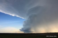
After the storm spit some one-inch hail on me I moved back east to Linton and then south on U.S. 83. The storm gradually weakened as it headed toward the ND/SD state border, but it provided lots of photo opportunities along U.S. 83. Here are two final shots that I took south of Hague near the border. Both look west:

IMG_5019.JPG IMG_2876.JPG

Here's a 8x time-lapse of my original intercept near the Missouri River:


This was my third time chasing North Dakota, and apart from the stunningly aggressive mosquitoes, I continue to love the light and the vastness that the state provides. It's a great place to chase.
 
Back
Top