Brandon Lawson
EF2
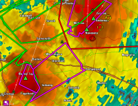
Seems a shame not to have a target thread today on one of the few moderate risks we've seen issued this year. Morning storms already in progress from Abilene to San Angelo with additional elevated junk northwest of Austin. Tornado warch in effect for much of northwest texas and southeast oklahoma.
Shortwave trough will be moving through the Southern Plains this afternoon atop a moderately unstable boundary layer. Dewpoints in the 70's will be encroached upon by a dryline draped across the west half of Texas.
Forecast and observed soundings show some mid-level weakness in winds, but overall deep-layer shear (40-45 knots) will be more than supportive of supercell structures within or ahead of already ongoing complex of the thunderstorms pushing in from the west by early to mid afternoon. Any development ahead of the line would also likely have the adavantage of storm motions near perpendicular to the dryline, assuming upscale growth doesnt line out everything.
Areas from south-central oklahoma into north-central texas and points eastward should see very large hail, high winds and tornadoes. Good luck to everyone chasing today and be safe. Roads are sure to be a mess with all the recent rains and more to come.