• A friendly and periodic reminder of the rules we use for fostering high SNR and quality conversation and interaction at Stormtrack: Forum rules

    P.S. - Nothing specific happened to prompt this message! No one is in trouble, there are no flame wars in effect, nor any inappropriate conversation ongoing. This is being posted sitewide as a casual refresher.

2015-05-24 REPORTS: CO/KS/MO/IL

Joined
Aug 16, 2009
Messages
814
Location
Amarillo, TX
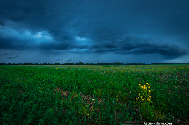
Surprised I haven't seen much of this day. I don't have all my photos and videos done, but enough to tell the story.

Woke up already knowing I was going to probably be in SE CO. Sure enough, early model runs pointed me in that direction. So we drove up to Springfield, CO where I met up with Skip, Brindley, Laubach, and the TIV crew. After letting storms develop, we drove north to the storm developing SW of Lamar. It was going through a merger phase so initially it didn't look great. But I know better than to leave, because all the storms were fighting for dominance. Sure enough, once one decided to be the boss...it became the boss. The supercell grew substantially at a fast rate. We saw a fake-nado that had me fooled for a while, but it was just some cleverly shaped scud. I thought we had a tornado here, but turns out we didn't.

full


full


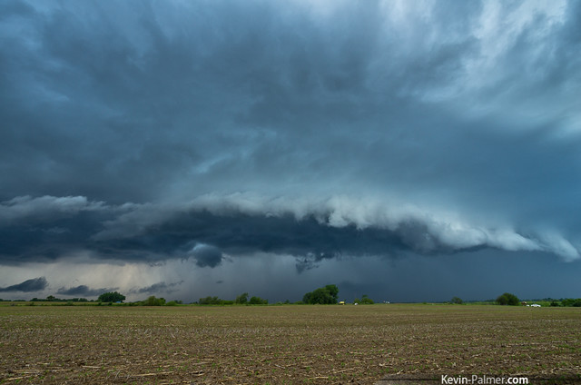
The storm was a beast for a while, but showed signs of weakening near Holly. So we went south to the next storm which, once again looked like a beast. But it was obviously pushing outflow. Still, one of the best structure shots I've ever taken.

full


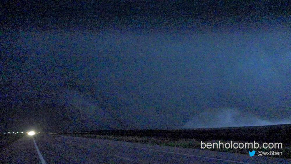
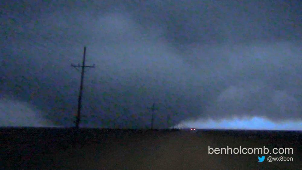
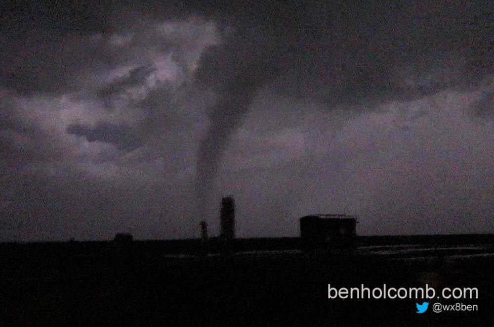
We drove east, no intentions on chasing much anymore. But the storms southeast of us looked impressive visually. So, we thought we'd skim by them and see what may happen structure wise. Well, on the way there, west of Ulysses, it went tornado warned. Game face came back on and we made a bee-line to the storm. Carefully hook slicing and getting within a mile of the very early stages of the mighty wedge. We let the storm get a little distance before continuing. We sat east of Plains looking northwest at it. It was a massive, mile wide monster. We noted a couple of satellites that may or may not have touched. We did see the handoff from one wedge to the next tornado, but the fog was rolling in so the camera couldn't get much of that action. All in all, I gotta say, 2% tornado days will always be my favorite.

full
 
Mods: could you please add MO and IL to title?

I had a somewhat unexpected and enjoyable chase in NE Missouri and west-central Illinois. The area was red-boxed by early afternoon, so I headed west from Jacksonville, IL with Hannibal, MO as a rough target. I thought that a reasonable play was the possibility that line segments from a QLCS moving northeast across central Missouri would eventually interact with a warm front draped east-west across the MO/IA border and northern Illinois. I played catch-up with several cells near Quincy, IL, but they were never warned and soon petered out in the more stable air to the north. So, I decided to cross the Mississippi River at Quincy and head a bit south to Palmyra, MO. Once I got there one small, gusty cell passed to the north of town, while a better-looking piece of the line approached from the southwest. It looked pretty good once it approached my position, which was one mile south of Palmyra. Here are two pictures of the storm. It wasn't warned, but it did have a nice organized look to it. The view in the first picture is to the southwest and west in the second:

IMG_4980.JPG

IMG_4970.JPG

I chased the storm back to the north and re-crossed the river at Quincy just as another line segment to the south and a bit to the east became - to my surprise - tornado-warned near Louisiana, MO. So, I blasted south and east on I-172 and I-72 and got off at the Barry, IL exit. There were two small cells at play here. I got cored by the leading one on IL-106 between Barry and Pittsfield, IL, but I managed to catch the trailing storm from a good position as it weakened considerably. Here's the storm's shelf cloud from a few miles west of Pittsfield. The view is to the southeast:

IMG_2654.JPG

Happy with what I had got, I called it a day and headed home.
 
Last edited:
Left late after picking up a storm chasing/photographer guest from the OKC airport at 1130 and heading up with a target of around Guymon in mind. Ended up in SE CO on the photogenic storms before heading into KS to play in the hail. The storm near Plains went nuts and I observed 4 tornadoes including 3 very large wedge tornadoes, one of them easily in excess of a mile in width.

Here's tornado #1 south of plains
CF3Z7dpUIAAA_L5.jpg:large


Here's tornado #2 North of plains, easily 1 mile wide

CF1PFgmUIAAvzCO.jpg:large


Third tornado north of plains, possibly the ropeout of #2

CF3gARdUEAA6TH3.jpg:large
 
I chased the MO/IL setup. I was hoping to play the warm front this day, but it was lifting too far north, too fast - all the way up into far northern IL by late afternoon. Just too far to go for me when a supercell environment also existed in my backyard. Instead, I followed a storm through the surface-based CAPE max from Montgomery City, MO (NE of Jefferson City) to near Bluffs, IL (west of Jacksonville). The storm had a nice rain-free base at Montgomery City, with a brief attempt at a wall cloud.


The storm cycled a few times with RFD/outflow undercutting, then finally ramped up in intensity and structure rapidly at Bowling Green, becoming tornado-warned:


There is only one river crossing for dozens of miles here, so I could not go north into the notch to get a better look at this. I opted instead to cross the river into IL and hope to get into the notch there. The storm, however, weakened rapidly as it crossed the river, becoming hopelessly outflow-dominant. Here is one more shot as it was crossing the river at Louisiana:


A second storm trailed the first, but was also outflow dominant. Storm speeds were thankfully around 30-35mph, making it easy to stay with things. I got back out ahead of the southern storm (still outflow dominant) on I-72 near Oxville, staying with it north for another 30 minutes in hopes it would re-establish good inflow. That never happened. This weird scud bomb at Bluffs was the only other photo-worthy subject this storm produced.


I headed back south to intercept a pair of supercells moving toward the eastern STL metro after dark. I caught the lead storm's dying circulation in Fairview Heights, with the city lights illuminating some weak rotation that passed directly overhead. No power flashes. A big squall line from the south caught up to the trailing supercell before it arrived, and didn't see anything else of interest during the rest of the 20-minute drive home from Fairview Heights.
 
Regretfully, after spending the night in Lamar following the previous day's chase of the tornado-warned storm near La Junta, we left Lamar at 11:00MDT in favor of a target in the TX panhandle that obviously busted... All indications were that dynamics on 5/24 would be less favorable than 5/23, and 5/23 hadn't produced the greatest results either... Not sure what the tipping point was to create Sunday's beast but would appreciate anyone's thoughts on that. Anyway, of all the things that can go wrong while chasing, leaving an area where you could have been within an hour's drive of a great storm has to be one of the hardest to take... Especially if the remaining four days of this chase vacation fail to satisfy, Sunday is going to be a tough one to have to hold onto until next year...
 
Snagged 3 tornadoes on the gorgeous Plains Kansas supercell. The first a brief rope south of town, the second wedge to elephant trunk. The third was north of Meade. Several chasers were waiting in the fog for the impressive velocity yin-yang to cross highway 23. The tornado appeared to dissipate on radar and a new one reformed west of the road. Caught a few glimpses of a thick elephant trunk on video, but not impressive enough to include in the package. Congrats to all who caught it.
 
I was busy until almost 7:30 Sunday evening. But I checked the radar and saw I had just enough time to get to a cell coming up from the southwest before it got dark. This storm was showing some weak rotation on radar. I approached the storm and watched this shelf cloud emerge over Canton, Illinois.


Shelf-ish
by Kevin Palmer, on Flickr

I wish I had enough time to shoot a time lapse of it, because the shelf structure was fun to watch. I relocated and got a few more shots as the line weakened and moved north. It was getting dark and I was hoping for some lightning, but it didn't happen.


Unshaken
by Kevin Palmer, on Flickr
 
Started the day in Lamar, CO, as it appeared evident that storms would fire up in this area. We waited for the cluster of storms to show us the winning cell, then managed to quickly move to the northeast of the mesocyclone, so we could have a view on it before the storm became HP. We filmed a beautiful roping funnel that never made it to the ground.

7180802101.jpg


The storm then reorganised and showed us a beautiful cone funnel that apparently had a circulation on the ground. (that would be the fake-nado Marcus Diaz talked about) I can't tell if it was or not, but I remember seeing a report of a clear ground circulation under the funnel. Anyways, it was beautiful.

8387036902.jpg


As the RFD started to wrap around the mesocyclone, we somehow managed to get out of the bear cage without getting hailed on.

The storm was still giving us some signs of an inflow, but as we couldnt see anything due to heavy precips, we moved south to see what was happening there. We quickly understood it was all going outflow dominant, but then saw the storms firing up in SW Kansas. We decided to give it a try.

We saw a 5 seconds lasting landspout north of liberal not very far from the northern storm's base just north of Liberal, KS. We then went NE on road 54, following the supercell close from behind, until we saw some night-time touchdowns that appeared to be in fact one large multivortex tornado. As it progressed, we saw it become a beautiful cone, then a wedge-looking tornado.

We tried to follow the storm on road 23 north of Meade, but as we were getting really close to the couplet seen on radar, all we could see is dense fog being rapidly sucked up to our north west. We called it a night.

I really love these kind of chasing days.

Here's a montage of our day. We're so happy that the plains-meade tornado occured on open field!!
 
Woke up in Goodland and headed south on KS 27. Got some fantastic BBQ at a house-turned-restaurant in Syracuse, KS, briefly ran into Bill Reed, though he was just heading out as we arrived, then went west into Colorado and sat just north of Holly. Surface wind was due east. We watched the first SVR-warned storm to our far southwest but decided to wait. It weakened as new showers popped up to its northeast. We decided that was the play of the day and headed west to Lamar, then south about 2 miles and watched. Structure wasn't great, with a "mote" of showers around the main supercell. Once those smaller cells merged in, we were off to the races. We went back through Lamar, and just as we turned right onto US 50, the TOR warning was issued. We found a road running south from Granada, sat there, watched a lot of suspicious scud and perhaps a funnel initially:

10941116_10205844085676576_3849302015846583649_n.jpg


Just as I was saying to the underclassmen in my car that I wasn't sure what we were seeing was actually a funnel, the rain curtain in front thinned out a bit and a large likely-funnel descended from the wall cloud:

11351200_10205844093476771_574887896332967733_n.jpg


It was still somewhat rain-wrapped the whole time since at this point the southern flank has been developing into a new supercell. But for about 30 seconds we had a good-enough shot of the likely-tornado. At the same time, another chaser reported a large cone tornado, which I suppose must have been this:.

11145894_10205844093316767_4958622863029176213_n.jpg


Then the rain in front intensified again and that was pretty much for viewing. A few minutes later, the meso on the southern supercell had tightened up and the northern meso had broadened out. We were in a good spot to watch that base, which was comparatively rain-free, but we didn't see any funnels from that.

We stayed with it and went east to Holly, then south about 15 miles. By that point, we had a bona fide QLCS on our hands, and saw crisp towers going up to the east. We briefly tried running after what would become the Plains, KS tornado-producing supercell, but quickly realized that we wouldn't make it before dark, so we got dinner in Ulysses, KS instead and sat south of town a mile or so and waited for the complex to roll over us.

All in all, not a bad chase day for one that started with low expectations given the mediocre showing in CO the past two days, and thee addition of a VBV profile.


Additional note: I'm not 100% the big feature we saw was actually a tornado. Marcus seems to have a better/closer shot and calls it scud, so I'm not sure. I'd appreciate any thoughts on whether what we saw was a legit tornado or not. Of course, my mediocre iPhone camera doesn't give many clues.
 
Last edited by a moderator:
Back
Top