JamesCaruso
Staff member
Targeted southeast CO today; you can read about my indecisiveness and second-guessing in the Events thread
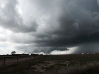
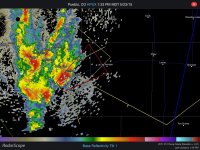
After lunch in Lamar, had the general intention to head west and north, maybe toward Limon, but rather than go north first (which would have been a shorter route to Limon, because 287 heads directly northwest out of Kit Carson), wanted to go west first and buy some time erring to the south, as winds were more backed than to the north. It was early though; figured winds would still back up toward Limon and that upslope would be enhanced by the Palmer Divide. Heading west first proved to be a good decision because we came upon a severe warned cell coming up out of Pueblo. A tornado warning was soon issued. The attached photo and radar image were at approximately 1:36 MDT while on Route 350 just southwest of La Junta.
There was a tornado report at 1:52 MDT but we did not see anything. We were a little further away at that point as we were repositioning to stay with the storm's northeast motion, but still had a view of the base. I can't imagine it was more than a brief spin-up if it was legitimate at all (no source was identified).
We tried to head north out of La Junta, cross the river and use route 194, which is on the north side of the river and paralleling route 50 - but the road was closed - so we had to backtrack to route 50. By then, a ton of chasers had come out of nowhere, and the road got a little crazy with everyone pulling off and pulling back on the road. The base was just getting further away to the northeast so we just wanted to keep moving east and get to the next north road, which was past Las Animas. We went north on 14 and then east on 96 to Eads but by now it was just a line. Still provided a couple of nice photo ops until we decided to let the line pass us as we drove back south to Lamar. Today's chase started early and ended early.