• While Stormtrack has discontinued its hosting of SpotterNetwork support on the forums, keep in mind that support for SpotterNetwork issues is available by emailing [email protected].

2015-05-08 REPORTS: TX/OK/KS/CO

Joined
Jan 14, 2011
Messages
3,535
Location
St. Louis
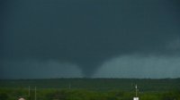
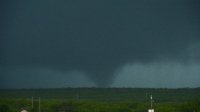
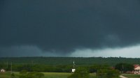
I was on the Lubbock-Graham storm today. I managed to see the Throckmorton tornado from the southwest (behind the storm), despite being out of position due to a sign that said the road I was on east of Wienert was closed (turns out it was not). I had to detour back to the highway and lo and behold had a clear view of the icipiently tornadic base. This tornado/base looked a lot like Cooperton 4/13/12, very low-broad circulation with a brief and weak wedge/cone condensing in.

I also lost my DSLR and 10-22 lens after placing it on the roof and driving off near Wienert. I went back to look for it, but the area was flooded.

Video:

may815at.jpg
 
Last edited:
Good job Dan. I was on the same storm from the time it was just North of Post until having to bail from the hail near Newcastle. It was looking interesting at that time, but saw the hail core coming and made a run for it. Ended a pretty disappointing day
 
For a Friday, there were a lot more chasers then I expected (in the N TX/S OK region). "Moderate" sure brings them out of the woodwork. A bust for me overall today. Got some nice structure photos and one decent dark-thirty lightning stroke, and was a bit out of position to see the Vernon tor but (lots of rain well out in front of the MCS system), but nothing to wrote home about. One thing is for sure, some regions of N TX and OK is getting some serious rainfall this week/weekend

Imagine what Saturday will look like!!
_SAM8293-L.jpg

_SAM8302-L.jpg

SAM_8495-L.jpg

_SAM8684-L.jpg
 
Chased the cell that went up SW of Quanah TX and followed it north of Vernon into far southern Oklahoma along I70. It was hazy and HP the whole time that I was on it and I decided not to venture to far into it just for a brief spin-up in the rain. Still a decently fun chase. Got a close CG shot on the iPhone while under the storm. On to Saturday....
0oeXnLd.jpg

01IeyX5.jpg
 
I also played the Lubbock-Graham storm, initially targeting Wichita Falls, TX. I played the northern storm near Vernon for a bit, but noticed better instability further down the dryline and the Lubbock-Graham cell was inching eerily close to a residual boundary likely left from previous convection. We initially intercepted the cell near Haskell, then followed it east on 380. Initially the southern edge was outflowish, but it interacted with better dynamics and started to look more organized west of Throckmorton. After re-positioning north of Throckmorton on Hwy 183, the storm developed more pronounced inflow as the base lowered, the rain free updraft region tightened and lowered, and rapid circulation commenced as the rain curtain was wrapping in from the downdraft area. The storm produced a nice multi-vortex to stovepipe tornado for several minutes before the rain obscured the area of circulation.


Attachments

  • tor1.jpg
    tor1.jpg
    118.2 KB · Views: 140
  • tor2.jpg
    tor2.jpg
    136.6 KB · Views: 140
  • tornado5.jpg
    tornado5.jpg
    154.9 KB · Views: 144
I played the Lubbock storm from birth, but fell way behind due to Highway 40 being completely submerged on several occasions. We were about 10 miles behind when the storm supposedly produced in Spur because out road ended from road construction. As I was making my way to get in front of the storm, I was already annoyed. I filled up in Aspermont, still really annoyed, but not done yet. We blasted to Haskell then north to head the storm off. East out of Weinert, and we were finally in front of the damn thing. The storm tried a couple times but never could produce. We got into Throckmorton and got just east of town as it was producing. Of course, didn't see a thing. We then were spending the next 45 minutes escaping the hailcore that seemed to go south. Ended the day with big greasy burgers from Sonic in Breckenridge, because why the hell not. The year of the HP was full force on this day.

pano-3-X3.jpg


Dunno if anyone else noticed the crazy cinnamon roll swirl in the precip at one point...
full
 
I played the HP supercell near Vernon, Texas and documented 2 HP tornadoes. I've posted a shot of the second. I have shots of the first but they ended up being out of focus due to heavy rain. I ditched the Vernon storm due to low visibility in favor of a supercell near Throckmorton in hopes of better visibility. This storm ended up high precipitation too, but exhibited great structure! I missed the tornado on this storm due to a closed road and severe flooding, sadly. Sorry for the image quality in the first. Was extremely dark and I was shooting at high ISO and fast shutter speed to avoid blur.

Vernon%20Tornado%202_zpsubvdque6.jpg


DSC_8605_zpszxhcpacc.jpg
 
Better Late then never ... from 5/8
Check out the two fisherman, between Vernon and Electra. Crazy. Handheld and a little "softer" then I like
_SAM8288-X3.jpg


NE Of Burkburnett, TX
_SAM8293-X3.jpg
 
Last edited:
Back
Top