2015-04-26 REPORTS: TX

Randy Jennings

Supporter
I left home just before 4 PM yesterday and spent 11 hours chasing. Unfortunately most of the action was after dark, so I didn't get good pics, but here goes. My chase partner was fishing on Lake Ray Roberts, so I had to dive about 40 miles to get him. After leaving the lake, we headed to Sanger and went south on I-35W towards Ft. Worth. Driving under the forward flank anvil, my chase partner took this picture of downtown Ft. Worth, with a tornado warned cell 64 miles to our southwest over Stephenville, TX.

storm1drive.jpg

We took the Chisholm Trail Parkway toll road towards Cleburne taking some pics to the southwest along the way. We could see some striations on the updraft.

storm1drive2.jpg storm1drive3.jpg
1.png

Trying to get the right flank to see the storm, we drove thru Cleburne down 174 to Rio Vista (note the cell we are on now is not the cell that produced multiple tornados in Rio Vista – as it tracked to the north of Rio Vista). We decided to not stay in Rio Vista for several reasons: lots of trees blocking the view to the west, slow data coverage, and no good escape routes (we didn’t want to drive north back into the storm and we didn’t want to drive southwest towards it). So we took 916 to 171 which had a good escape route southeast towards Hillsboro. We lost all data coverage by the time we got to 171, so we drove a little south on 171 until we got data again to see radar. Seeing the storm was tracking towards Cleburne, we took 171 northwest towards Cleburne. From the north side of town, we watched as the cell dissipated to the northwest over Goodly and took this pic.

storm1clap.jpg

It was getting dark, and while watching that cell dissipate, we watched another cell build towards our southwest. It too became tornado warned, and I took this radar capture before heading back to Rio Vista.

5.png

I'll cover chasing the second cell (the one that produced 3 confirmed tornados in Rio Vista) in another post.
 
We got to Rio Vista and I felt even less comfortable this time, as it was very dark and we couldn’t see much of anything, yet we knew it was there. So we cut over southeast to Itasca (which is on I-35W). This cell took its time, and we sat in Itasca for close to a couple of hours as the storm moved into Johnson county and just kept cycling doing loops west of Rio Vista (which was 14 miles to our northwest). We meet up with a couple of chasers for Fox 4 in Dallas. We kept looking, but couldn’t see anything. It finally started to move to the east of Rio Vista and we measured inflow at up to 35 mph.While in Itasca we took a couple of snapshots of the radar (unfortunately I didn’t take one when velocity was showing 3 rotations in a row). Note that another cell formed behind, and also note how long it is in the same area.

7.png

9.png

11.png

After relocating slightly twice, we got a better view and we saw a couple of power flashes as it approached Grandview (which was 7 miles to our northwest). I reported the power flashes to the Johnson County Skywarn Net. Eventually we did see the wall cloud backlight by lighting, but could not see any funnel or tornado. I reported it to the net. We also where keeping a close eye on the radar, as another cell was right behind the one we were watching. Inflow was at our backs as we looked northwest towards Grandview. Then something very strange happened. We started to get a cross inlow from the east shaking our vehicle some. Realizing something was wrong, I took a quick look at velocity, only to see the cell to the rear trying to pass on the right and coming at us. We quickly headed south on I-35W towards Hillsboro and experienced both a strong head and cross wind. We took this velocity snapshot on the way:

13.png

We decided to keep going towards the city of West. Between Hillsboro and West, police had shut down all but the left lane for a road crew that was striping the interstate in the middle of a tornado warning polygon. You would think all the emergency alerts going off on cell phones would have caused them to stop – but evidently not.

lanePainting.png

We stopped in West for a bio break and to get a kolache at the famous Czech Stop. We got the bio break, but not the kolache. As we where waiting in line, the young employee working the store got a call from his manager who told him to kick everyone out and close the store as a tornado was on the way. My chase partner did get a free coffee as the employee was very nervous and wanted everyone to leave quickly and would not take any money. It was starting to rain heavily, so we headed a little more south to wait the storm out (stopping at another gas station that was locking the door and placing a sign saying they were closed for 15 to 30 minutes because of the storm). Once the worst of the storm passed, we made our way back north trying to cut in front of another sever warned cell. When we got back to Itasca, a tractor trailer (cab and all) had been blown off the road and tipped very close to where we had been stopped earlier. As we drove back up I-35W, we watched the light show to the east, and did see a few power flashes from the straight line winds. We also took a radar snapshot (note the bow is 70 miles from tip to tip):

15.png

We listened to the Johnson County net again and heard lots of reports of flooding and trees and power lines down in roads. Luckily it sounds like no one was seriously injured or killed (NWS has now rated 8 tornados at EF-0 as of tonight). I dropped my chase partner at his house and arrived home at 3 AM. I’ll have to try to slow down the video I took to see if I can see anything in it. I also want to commend the Johnson County hams. They had a first class net, with good spotters and a good NCS. They were active for a very long time; with have rains, very large hail (softball size), tornados, and flooding and they did a great job.
 
I intercepted 2 supercells Sunday. One between Hico and Stephenville, the other just east of Stephenville near highway 67. Watched them move real slowly toward me. Both had confirmed tornadoes on them, however, you really had to be in the cage to see them. Definitely the best structure I've ever seen. Did see either a possible tornado or gustnado on the Hico storm. Leaning toward gustnado.
 

Attachments

  • image.jpg
    image.jpg
    177.1 KB · Views: 259
  • image.jpg
    image.jpg
    158 KB · Views: 257
  • image.jpg
    image.jpg
    220.4 KB · Views: 258
  • image.jpg
    image.jpg
    243.6 KB · Views: 258
  • image.jpg
    image.jpg
    218.8 KB · Views: 267
  • image.jpg
    image.jpg
    181.1 KB · Views: 265
What a fantastic day this ended up being. I really wasn't planning on chasing as we were returning from an all weekend camp. However, it was just too close and hard to ignore so I headed West out of Dallas at around 3:30. My buddy Zack Biggs did some nowcasting for me and helped me to target just south of Glen Rose for the tornado warned storm that was coming up from Stephenville. I missed the insane early structure however the storm was still pretty nice when I got there:

11182656_10152679624901626_7108935480947838440_o.jpg

Just South of Glenrose on 144

10271353_10152679624496626_6246367121466431364_o.jpg

The first storm started to fall apart but was beautiful as it did so.

I repositioned farther West for the next cell coming down the line. It was near Stephenville when I started to get into terrible chaser traffic along 67. This was the theme for the rest of day due to the very limited road options. I found a little side road just west of Stephenville and setup for about 20 minutes to time lapse and taken pictures as the core of the storm approached my location.

11174673_10152679624481626_4967997811490615723_o.jpg

The lightning here was incredible.

10953909_10152679625631626_7612128505769984633_o.jpg

The meso really started tightening up here, however I was getting very nervous about hail and so started packing up my gear to move farther East.

11076725_10152679625606626_6356635049445850336_o.jpg

Wouldn't you know it a brief tornado formed right after I packed up! I quickly grabbed a camera and shot a few pictures as it lifted. I then took off so that I could get East.

1836935_10152679625691626_1631147329279123418_o.jpg

The storm took on a beautiful stacked plates look as it drifted to the East. You can see a well developed wall cloud on the horizon.

I decided at this point to move back West and intercept another cell coming up out of Stephenville. This was a great decision as most folks were still well East and the new cell was incredible.

11143545_10152679624631626_5162963520560156869_o.jpg

Here's a single image from a time lapse I shot at 14mm. The motion was amazing. I was able to just skirt the precip core so that I could shoot for a while here.

11089006_10152679625686626_5943066980090585336_o.jpg

One last view of the storm before it got a bit too close and I needed to head East.

After this it was starting to get dark. I head back East on 67 to GlenRose and then south on 144 to avoid the monster now tornado warned storm approaching GlenRose from the West. The inflow as I was driving down 144 was strong enough to almost push me off the road. I stopped about 10 miles south of town to watch the hook overtake the town, observing several power flashes (reported) and a nasty looking wall cloud. After consulting with some friends, I head farther south along 144 to Meridian and then East towards Hillsboro to avoid the 3 or 4 supercells lines up to north. I was able to get onto I35E and head back up to Allen just ahead of the large tornado warned storms to my West. The lightning as I was coming into Dallas was some of the most incredible I have ever seen.
 
My target area for this day was never further SE than CDS. Wanted to stay close to home and I am not a fan of chasing east of Abilene. There were 2 potential targets in the TX Panhandle. The NW Panhandle closer to the low or in the SE Panhandle with better moisture (that never arrived). After talking with @Marcus Diaz around noon, we both ended up driving up to the Dumas area. First storm near Hartley had great low level structure, but you could see the top of the storm was being blown into the next county. As it died we bailed SE through the core of the next storm. The roads were getting covered in hail at this time. I ended up just east of Masterson as a large RFD surge came around on this second storm giving it a nice hook. The structure was classic. Spotted a funnel or 2 during this time. As that storm died, made a pointless effort to dive further SE to around the Panhandle storm, only to arrive as the storm died. We had one last effort on a storm that formed south of Claude. The rotation on this storm was in a strange place and I almost drove right by the couplet. I was looking a velocities and noticed some weak rotation "in the middle" of the storm. I glanced out my video to see a good sized funnel get wrapped up by the rain before I could come to a stop. Not as eventful as down south, but it was a fun chase and I was home before 8pm.

South of Dumas:
11181233_10103098903893647_712513624066211434_o_zpsg9qhjkjw.jpg


Video from the chase (starts near Hartley and ends near Masterson, south of Dumas).
 
Left around 10am and intercepted the first tornado warned storm east of Anson, but bailed to the south monster. Lost a windshield in the hail, witnessed some incredible structure and a pretty large but occluding cone tornado east of Stephenville, TX. Chased after dark and witnessed another tornado under a big bowl and some big hail. All in all, a great chase day for me, the best since perhaps Moore 2013.

 
Left Shreveport at about 10 AM for the DFW area. Ate lunch at In-n-out burger, and by the time we were done, supercells had initiated to our west along the dryline. Moved west and then south to the supercell near Dublin, TX. It had some of the best structure I have ever seen.
IMG_1561-2.jpg


IMG_1615.jpg

IMG_1630.jpg


We did at one point see what appeared to be a cone funnel, but lost visibility extremely quickly and never got any pics/video of it. A pic surfaced from another chaser that showed a likely tornado. Torn as to whether or not to count it as my first tornado of 2015.

Followed the storm until it died, and then moved back West to Stephenville, TX for the next supercell. Stayed ahead of it on HWY 67 for quite some time. Once again, it had INCREDIBLE structure.
IMG_1649.jpg

IMG_1661.jpg


Also stayed on this storm until it died. We decided not to move West again for the next storms, as it was getting dark... so we called the chase and made it back to Shreveport at around midnight.

Great chase!
 
Another frustrating chase.

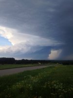
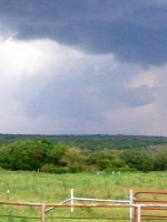
Left Norman just before 11 AM. Initial target was somewhere near Stephenville. Planned on taking U.S. 281 south from Wichita Falls to get there. After lunching in Wichita Falls, however, we noticed storms exploding off to our southwest. We kind of missed/overlooked the storm farthest south, and at the last second at the junction of 281 and TX-79, went towards Archer City instead. We intercepted a supercell while north of Albany as it approached from our southwest. It initially looked pretty good and even appeared to try to produce a tornado, but it went outflow dominant and we abandoned it. At this point we decided that we would try with new storms developing immediately west of the current storm, back where there was more clear sky and heating, and just ahead of the dryline. That turned out to be a mistake, as we didn't consider the poor moisture return thanks to the first tornadic supercell moving eastward to our south. Add in the outflow from our first storm, and I think it just messed up the environment too much. Regardless, we drove all the way west to about 10 miles east of Anson before turning back to the east.

Honestly at this point I thought we were screwed for the day. It looked like outflow from the primary supercell - by this point nearing Stephenville - was going to persist and completely ruin the environment we were in. We didn't think we'd be able to get east and then south fast enough to get on the storm, but we drove east anyway, albeit somewhat leisurely. We stopped in Breckenridge for gas and then entertained ourselves by letting ourselves get cored by a new storm that popped up just south of town and had 60+ dBZ on it. We only got very small hail out of it.

After that core passed we noticed new development due south of us and a little behind the primary supercell. Although it was north of the outflow boundary, it looked to be growing fast and was headed generally NNE - almost right at us. So we zoomed south on U.S. 183, diverting to TX-112/TX-6 to Eastland, where we caught some small hail from the north side of the left split of what was becoming the second tornadic supercell of the day.

As we moved south towards Carbon, we had to decide to either core punch the storm by continuing southeast on TX-6 or by sliding in behind it by taking a ranch road (1027). We chose the latter. Although I doubt the core punch would've ended well (given what we encountered on the ranch road), we definitely did not help ourselves by making this choice. The road was twisty and was absolutely covered in hail from the core. There was also a lot of water very near the road surface. The biggest stones were golf ball sized, and there were plenty of 1" and larger stones.

150426_010.JPG

Not only did the hail and road path slow us down, but we also had lost internet by this time. We got one radar scan around the time we got to FM587 that showed the storm had a bizarre shape and didn't look organized anymore. Couple that with the knowledge of it being north of the outflow and how friggin' cold it was in the cold pool (car temp was 13-15 C the whole time), we figured it was not going to pose a tornado threat, despite having a nice wide base easily visible to our east. We passed on it and got on TX-36 southeast towards Comanche.

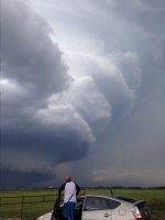
I saw an MD suggesting the tornado threat would increase between 00Z-01Z as the atmosphere south of the outflow was recovering, and we were very near the boundary and could see clear skies to the south with new storm bases to our southwest. One particular base, which would become the third big storm of the day, was clearly visible to the distant southwest and looked good.

Even after we reached Comanche we could get absolutely no data. I had to call a friend to ask what the radar was showing around us. He informed us that the storm we had previously left (#2) was producing a tornado near Stephenville. We chose not to go after that storm because 1) we figured we were too far behind to catch up, 2) it was wrapping hard and we'd have to get east of it, and 3) the storm to the west of Comanche had improving looking supercell structure and a mean looking cumulus tower aloft.

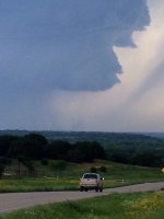
We went north of town on a few different roads to get a good view of this storm. It briefly developed a wall cloud that was slowly rotating and even appeared to try to produce a funnel cloud before the RFD came in and blew everything out.

150426_014.JPG

We went back to town and went east on U.S. 67 to intercept it up the road. We had plenty of time to wait for it to pass us by Proctor. It again developed a large wall cloud with continuous upward motion, but little, if any, rotation could ever be discerned. A large RFD punch came in but never did anything.

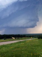
At this point we were getting in behind the core and put ourselves just behind the updraft base. There were several areas that were low hanging and occasionally appeared to rotate, but we never saw any sustained rotating wall cloud. It really looked like the storm was struggling to convert shear into vertical vorticity in the low levels.

150426_033.JPG

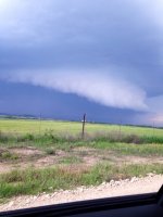
I don't know if anyone else saw this, but the feature in the image above, shot looking northwest from U.S. 67 just a few miles southwest of Dublin, was rotating and pulling in scud. The problem was it was well removed from the updraft base and was basically behind everything, so I don't know what it could've been.

Anyway, we found stones up to 3" in diameter laying on the street in Dublin. Then we headed east on TX-6 again, stopping for awhile a few miles east of town. The updraft base continued to look high and generally non-threatening. To the north of the highway, in the core, we saw this suspicious feature.

150426_036-1.jpg

It doesn't appear it was anything, just a tease to the eyes. But perhaps someone else saw this from a better angle.

Anyway, we let the storm get a little ahead of us here, so we had to catch up. Darkness was setting in as we moved east on 6, and we briefly stopped to observe what looked to be wrapping rain curtains, but by the time we could see again, nothing was apparent. We saw it again after turning north on 281 again, but it was getting really dark by this time, so it was hard to make anything out. We cut back up to 67 again via FMs 1824 and 2481. By this point it was almost completely dark, and even though we could see some sort of darker column under the base, it was too dark to tell for sure if it was anything. All I could manage to shoot was this blurry image.

150426_041.JPG

The absence of lighting to this point was remarkable. Almost nothing. It started to pick up after we got back to 67 and were basically ready to call off the chase since the storm had, in our experience, continually failed to produce anything resembling a tornado. We were right behind the hook at this point and were ready to head home, but the storm was basically blocking our route back to I-35. We said, "to hell with it," and hook sliced and core rubbed our way past it. We could never see anything ominous during that passage, and only encountered about quarter sized hail in our brush-by of the core northeast of Glen Rose. Sure enough, as soon as we got clear south of Ft. Worth, the storm began producing tornadoes. Whatever...

We watched the madness unfold on the way home.

I'm ready for May/June. I'd appreciate some easier chases where the moisture is not an issue.
 
Last edited:
First tornado-warned cell near Rising Star with Sam Barricklow and Carson Eads.
11163760_10205461941540775_6193368669093837113_o.jpg


Just north of Comanche, this emerged.
11018845_10205461942220792_7057344355038818090_o.jpg


The newly forming storm that would become the behemoth around Stephenville and eventually producing the tornadoes around Rio Vista later in the evening.
11164740_10205461945340870_7549598209745731033_o.jpg


We let it get out ahead of us as prior storms didn't look all that great visually from the inflow side and previous tornadoes were heavily rain wrapped. I wanted to get a look at the updraft lit up by the sunset colors. After seeing the jaw-dropping structure shots of others, I wish now I would have gotten ahead of it. Still, this was a sight to behold watching the updraft billowing upward like a nuclear blast cloud.
11149307_10205461946940910_2547530070093078960_n.jpg
 
A fun and intense chase across north central Texas. I can say Im not a fan of the terrain/road network. Anyways, we intercepted 3 (actually 4 if you count the first storm we check out) intense tornadic supercells, each of them producing hail up to softball size. We managed to catch a couple HP tornadoes embedded deep within the notch by doing the bears cage tango much of the day.

Full log: http://www.aerostorms.com/april-26th-2015-dublin-stephenville-texas-tornadoes-and-large-hail/

texas-funnel-cloud-600x338.jpg


DSC7744wm-600x397.png

11178344_1571213263145909_9035676685514769036_n.jpg
 
Back
Top