Jeremy Perez
Supporter
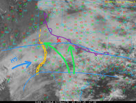
So, for whatever it's worth, a quick analysis of 17Z satellite/mesoanalysis for today from my virtual chasing armchair spot—
The cirrus canopy is one hindrance, but still forecast CAPE from 1500-2000 j/kg between the dryline bulge and surface front across north-central Texas. Virtually speaking, I'm looking at the vicinity of Aspermont, TX as one option with 50-70 kt bulk shear and 200+ m2/s2 SRH by mid-late afternoon, assuming initiation with the cirrus-filtered insolation.

The cirrus canopy is one hindrance, but still forecast CAPE from 1500-2000 j/kg between the dryline bulge and surface front across north-central Texas. Virtually speaking, I'm looking at the vicinity of Aspermont, TX as one option with 50-70 kt bulk shear and 200+ m2/s2 SRH by mid-late afternoon, assuming initiation with the cirrus-filtered insolation.

