• While Stormtrack has discontinued its hosting of SpotterNetwork support on the forums, keep in mind that support for SpotterNetwork issues is available by emailing [email protected].

2015-03-24 EVENT: OK/KS/MO/AR/IL

Joined
May 1, 2004
Messages
3,417
Location
Springfield, IL
...or maybe rename this thread NON-EVENT. Call me a sucker, but I'm looking at the IA/NE/MO corner for a possible cold air event on Tuesday, March 24. I've made the haul out there for setups like this in the past and been burned with just pancake cumulus so I don't know why I keep giving these my consideration. I guess I'm hoping for that surprise IA tornado outbreak that nobody is on because they didn't see it coming, the conditions looked too marginal, or they were all chasing linear crap in the warm sector further south in the jungles.

Here's the deal though.

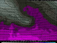
We've got this real nice negatively tilted trough and shortwave that's been plotted on the GFS the past few runs:
gfsCGP_500_spd_108.gif

With the height falls, synoptic scale lift, and deepening surface low I'm hoping we're going to see substantial lift here and not get burned again with pancake cu.

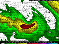
Moisture and instability are super marginal:
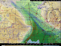
gfsCGP_sfc_dewp_108.gif gfsCGP_con_mucape_108.gif


But here's the catch:

gfsCGP_500_temp_108.gif

We've got a lobe of really cold air aloft pivoting over the top of that meager moisture axis. That's going to destabilize our warm sector with some really steep lapse rates and could set the stage for some robust updrafts. It's the kind of setup you can get mini supercells with tornadoes out of.

These cold air setups can be super finicky though, and this event might just up and disappear once the NAM is in range. Watch that cold air aloft and the moisture axis closely though. If those come together, we might get a nice little event up there during the afternoon if some heating can melt off the inhibition enough for surface based convection under that cold air aloft.
 
500j/kg can get it done in that near-surface low environment if that CAPE is concentrated at/near the surface. That said, I'm a little concerned at this point about how far away the surface low is from the workable moisture. It may be too far northwest to bring enough in the way of low-level shear to help such a meager CAPE axis. My feeling if things play out like this is to opt for the slightly better instability available to the south, as there will likely be that sweet spot compromise between shear and CAPE. A more southerly surface low track could make this a really nice early-season play, in which case the immediate low environment (E-SE quadrant) would be a no-brainer.
 
Agree on both accounts above. Nice mid-level dry punch/cold air aloft makes it look like a low-topped supercell day in southern IA if the surface low gets better organized with the approach of that potent shortwave.
 
Today's 12z NAM and GFS couldn't be further apart in terms of their surface low placement. The NAM would shut off any potential in Iowa altogether (not that many would complain about that.)
 
I like the wind profiles pretty much warm sector-wide on both the 12z NAM and GFS. Hodographs look really nice in northern/central MO. The downside is that 0-1km CAPE is really lacking in that narrow instability axis, and not quite extending far enough north for my liking. If the 12z version of things verifies, I think we're in business if we can luck out on better-than-forecast instability. Waking up to a nice dry slot on the first visible satellite will bode well for the day. If I had to pick a target strategy today, I'd probably be heading to Moberly with a short leash to jump back to I-70 if things can't get going in that northern target. I think we'll have a better shot at a beefier storm down along I-70 the way things show now. Either way, this is definitely a chase day, just a question of where.

EDIT: The 18z runs point more to a Columbia-Sedalia I-70 target.
 
Last edited:
As much as I want to, I have a hard time believing the NAM 72 hours out. That said, I do like how the 00z NAM hints at a deeper and more compact surface low over N MO. Obviously, kinematics shouldn't be a problem with this setup, but I'm concerned that thermodynamics will be. I just have a hard time believing we will get quality moisture that far north given those funky trajectories in the GOM.
 
...or maybe rename this thread NON-EVENT. Call me a sucker, but I'm looking at the IA/NE/MO corner for a possible cold air event on Tuesday, March 24. I've made the haul out there for setups like this in the past and been burned with just pancake cumulus so I don't know why I keep giving these my consideration. I guess I'm hoping for that surprise IA tornado outbreak that nobody is on because they didn't see it coming, the conditions looked too marginal, or they were all chasing linear crap in the warm sector further south in the jungles.

Here's the deal though.

We've got this real nice negatively tilted trough and shortwave that's been plotted on the GFS the past few runs:
View attachment 7142

With the height falls, synoptic scale lift, and deepening surface low I'm hoping we're going to see substantial lift here and not get burned again with pancake cu.

Moisture and instability are super marginal:
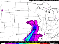
View attachment 7143 View attachment 7144


But here's the catch:

View attachment 7141

We've got a lobe of really cold air aloft pivoting over the top of that meager moisture axis. That's going to destabilize our warm sector with some really steep lapse rates and could set the stage for some robust updrafts. It's the kind of setup you can get mini supercells with tornadoes out of.

These cold air setups can be super finicky though, and this event might just up and disappear once the NAM is in range. Watch that cold air aloft and the moisture axis closely though. If those come together, we might get a nice little event up there during the afternoon if some heating can melt off the inhibition enough for surface based convection under that cold air aloft.


Skip I would say your close on the area, as of today looking at the models, I would pick an area NE OK, Kansas on the Western boarder of MO.
 
I really want to like NE OK on the border of NW AR for a local chase tomorrow. The 18z NAM has a lot of good perimeters in place at the 7 pm time frame (CAPE 2000 +, LCL 900, LI -8, EHI 3, as well as other goodies). BUT, the lower level winds are weak and veered, hodos are somewhat pathetic, and there's no lifting mechanism. The mid-level jet is up in KS and MO hogging all the divergence and lift and hanging out with the cold front. Perhaps there's a weak dryline jammed in OK somewhere, but I just don't see any serious lift. The GFS tells me to stay home, so I won't go there.
 
The NAM is giving me mixed signals up north. The forecast soundings for SW MO show a dramatically weakened CAP (800-700mb) from 21Z to 00Z...However, the 850mb temperature advection displays warm advec with SW winds at these levels. Perhaps those winds are bringing in some helpful low lvl lapse rates from OK to offset this. Regardless, with the vort-max situated far from the instability axis, there appears to be little lift other than weak isentropic lift along the warm front (but moisture/CAPE will be an issue there) and the general lifting that comes with the incredibly fast jet max. This may be enough to poke through the CAP before dark and give us a semi-discrete supercell. But I'm betting that by the time any cells get organized, daylight will be gone, and the lowering surface temps will kill our instability relatively fast. I know this may be a total long shot, but PERHAPS there could be some outflow boundary assistance from the morning convection that NAM simulated reflectivity is showing? But I think in this case, air mass recovery from a prior storm will be difficult with the overcast sky most of the day that the soundings are suggesting.

For the southern areas, I'm seeing a dryline that could produce a little convergence, but the winds flowing parallel to it are nasty. And not like, "Oh man, he caught some nasty air on that paraglider." More like, switching from whole milk to skim milk in one night nasty. There will probably be some line segments down there...maybe even a weak spin-up...but it's a little too far of a drive from Kansas City to be worth it.

Now I have to ask myself....how desperate AM I???
 
I am pretty sure Bryant Burrough and I will be going out tomorrow, just to fine tune a bit for the upcoming weeks. We like the I-49 corridor near Joplin between 4-6pm. The nam shows some real nice storms firing in that area and we can just get some localized backed winds we could be in business. None the less, the local hazardous weather outlook is only mentioning a low risk of a tornado. Only time will tell. Good luck to any and all who dare to chase tomorrow!
 
With regard to one of my comments...If the sky is overcast...I suppose the loss of daylight will not be as instantaneous of a hit on instability as I first suggested...the clouds would somewhat insulate the sfc temperatures for a little while.
 
The area from north Texas (north of Dallas) to far northeastern OK is starting to catch my eye. Looking at the 18Z + 27 (2015 03 24 21Z) NAM, I see surface Td around 70, 35-40kt bulk sheer sfc-500mb (although 0-3km helicity seems a little low unless you move east), 3000 CAPE with the cap eroded, LCL height nice and low at 1000m, and with temps close to 80 a resulting T-Td diff of 10 degrees. While I’m starting to like the moisture, instability, and shear, I’m less convinced on if the boundaries will be in the right place at the right time. Couple that with the GFS that isn’t as ambitious with this setup as the NAM, and I think I will stay home and hope it doesn’t wreck the setup for Wednesday. But I will virtual chase starting in Atoka, OK at 6 PM CDT, but I’m not expecting much excitement.

Stepping back from the models for a while and looking at the 2015 03 24 00Z observed soundings, I like the lapse rates at FWD and OUN (and like the lapse rates out west at MAF and AMA even better and they are headed towards my target area). However, I’m not too impressed with the dew points along the gulf and at DRT. I’m starting to think the NAM over did this setup.
 
Nice lapse rates back at ABQ at 00z, but as many have mentioned, the moisture is underwhelming and no rapid increase is on the horizon based on observations. I'm not sold on the model forecasts showing mid 60s dewpoints - I suspect 58-62 will be more realistic, which means CAPE will also likely be reduced some compared to the NAM. The shortwave trough is fairly compact and its influence won't extend too far S, so it's unlikely that low-level shear will be very strong S of MO. The northern track of the wave also casts doubt on how many storms will form as far S as eastern OK, especially considering the somewhat marginal moisture. Several of the convection-allowing model forecasts look reasonable - a small window for semi-discrete storms in MO before the storms try to outrun the narrow moist sector.
 
As expected...short range models are not as hunky dory on moisture transport as previous runs of the NAM. I expected this, seeing a rapid jump of moisture with time on the NAM for no apparent reason. I still think 1000 J/KG of buoyancy for SW MO is reasonable to expect. Strong upper level winds will probably weed out the weak updrafts and keep things ventilated.

It will be interesting to see how the sfc low sets up...models are disagreeing as to the degree of backing in the low levels.

I am encouraged to see the timing of initiation being around 5-6pm on the RAP.

I will be chasing with Eric Matthews and Brian Davidson...because why not.

Good luck everybody.
 
Latest HRRR has some storms forming in extreme SE KS by about 21z but it looks quite linear. UH product does show an embedded supercell signature a bit later but in the heart of the Ozarks. I think tomorrow is a much better chance for seeing something interesting in more favorable chase terrain. (not that I can chase in either situation...)
 
Back
Top