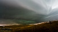
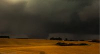
2013-10-04 REPORTS: OK/KS/NE/IA

Stephen, while assembling a file of storm photos from the Wayne tornado day, I find myself returning again and again to your classic photo of young chasers near West Point, looking at the distant prospect of what is to come. --This is photographic poetry.-- It is great on so many levels, the calm before the storm, the mix of light and shadow, perfectly posed with distant towers framing the sky, and next to a field awaiting the harvest. It is more peaceful than expectation --as if they wished it could go on forever, just the way it was at that moment. You have an artist's eye, and I look forward to seeing more of your work in the future. - - - David Hoadley

David, well said! I noticed that picture too... My focus was the "calm before the storm" element, as it captured the always awe-inspiring contrast of the often beautiful day that precedes a severe weather event. But you made me aware of other elements as well. There is another interesting dichotomy in what you said about "wish(ing) it could go on forever" - yes, but at the same time anxiously waiting and hoping for the real show to begin.

Great shot Stephen, well done! It is a wonderful thing to take a shot that garners admiration from David, one of the founding fathers of chasing.

And it is also a beautiful thing that David - a man who has seen it all, both in pictures and in person - can still be so inspired by a photograph: a testament to David's passion and another illustration of a storm chaser's never-ending love affair with the sky.

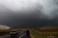
Thanks James and David. It was really one of those shots that composed itself. As for the chasers they are mostly University of Nebraska meteorology students. I am an undergrad at Nebraska and was chasing with fellow students on this day.
 
Just saw an Internet post (Dirk Lammers, AP, Rapid City Journal, Oct. 13, 2013) about the loss of tens of thousands of cattle in western South Dakota, due to the early October blizzard (2-4 feet of snow) last weekend. This was the same storm that produced the Wayne, NE tornado, one of 18 reported in eastern South Dakota and western Iowa on Friday, Oct. 4. Cattle losses for individual ranchers could be as much as $250,000, and the majority of them are not insured. “State officials said at least 10,000 to 20,000 head of livestock died, but the estimate will likely rise…western South Dakota lost at least 5 percent of its cattle…”
 
It seems to me that there are a number of estimates floating around and they range anywhere from 10,000 to 100,000.
Lincoln Journal Star is reporting between 60,000 and 100,000 killed.
http://journalstar.com/news/state-a...-f6db9b8f01a8.html?comment_form=true#comments
This story from the Rapid City journal States 5% of 1.5 million which would be 75,000.
http://rapidcityjournal.com/news/te...cle_558ef3ed-e941-5054-bc6b-115e04e10886.html
No matter what the final tally will end up being it was quite the blow to the industry.
 
Got a little up close and personal with the Wayne wedge. Inflow winds blew out the back window as I reversed it down Highway 15 (you can see me in Zach Hargroves video before he cuts it.) Incredible sight! After losing time to repair the window and attempt to get all ym waterlogged technology back up and running we got on the far backside of the Moville storm on Highway 20 but by then it was near dark and we could never see anything other than a massive RFD cut with a lowered area obsured by hills. What a wild end to the season.

7803471c8d2ae94da7c58c89aca2795d.jpg

6066d49d74fb3fd21f0f2e14bbfbb525.jpg

Full Account: http://www.aerostorms.com/wayne-nebraska-ef-4-tornado-october-4th-2013/
 
I still really had no clue as to what I was doing back in 2013, and I also didn't have mobile data or radar. I got caught up in construction traffic and sat behind a pilot vehicle for probably 15 minutes just outside of Norfolk, NE. Little did I know back then, but I was in perfect position had I just stayed in that exact spot... The updraft base that would eventually produce the Wayne, EF-4 was actually developing just to my S/SW but it was so benign and boring looking at the time, that I actually had no clue what I was looking at. I continued to go west once the pilot car let us through and started getting into some heavy rain/hail which was actually the Wayne cell now starting to explode and gather strength. Now caught in the core I heard over the radio that there was a large and extremely dangerous tornado on the ground and moving north/northeast. This had me extremely confused because this storm looked like such garbage not very long ago. I knew the tornado was either coming right at me or was going to miss me just to my east. I booked it back west because I figured it was the only safe option. Once I heard through the radio that the town of Wayne was just hit I knew it was safe to go east through the hook and try to get a view. As I came through Wayne and entered the industrial park I encountered major damage. Tractors flipped, buildings torn apart, gas in the air, powerlines all over the road, it was my first time seeing tornado damage, pretty intense stuff. I called 911 for a lady that ran up to my car and asked for an ambulance, and then got out to see if there was any other ways to help. I noticed off to my northeast that it looked like the tornado was now visible behind the storm as it was occluding. Here is a video still of the end of the Wayne, NE tornado with damage in the foreground.
full
 
Since this was bumped here is one of my videos from that day.

This one is a short preview clip showing the start of the tornado.

We were in great position the whole time but were able to stay away from the window busting winds. ;) The ghost train was amazing!
 
This turned out to be a fairly good day for myself in Northeast Nebraska into Northwest Iowa. Wish the terrain over that area was better, but we still managed to witness 3 (possibly 4) tornadoes from Bancroft, NE up to nearly Cherokee, IA area. The catch of the day for us was the long lived Climbing Hill/Moville, Iowa EF4 tornado, that was up to 1.5 miles wide at its widest (according to NWS FSD). I caught it crossing a bit south of the small town of Climbing Hill, Iowa as a cone/multiple vortex and then watched it quickly "wedge-out" northeast of town. Certainly a close call for that small town. We called the chase near Cherokee, Iowa as darkness fell. These are the only October tornadoes I've witnessed in my chase "career". I've attached a video still of the wedge tornado northeast of Climbing Hill. Quality isn't the best, but the camera I shot it with wasn't either lol.

One of the only regrets of the day was not going after the Wayne, NE cell earlier on just to the northwest, but again who knows if we could have caught up to this in time either. Or perhaps, I could have been on the northeast side of it (Climbing Hill cell) and caught the great structure/tornado combo too that a few others caught. Such is storm chasing though!

9cfa245ffafdfd8834009fc05248c6a1.jpg
 
Back
Top