2012-05-29 REPORTS: OK

Bill Hark

EF5
Joined
Jan 13, 2004
Messages
1,348
Location
Richmond Virginia
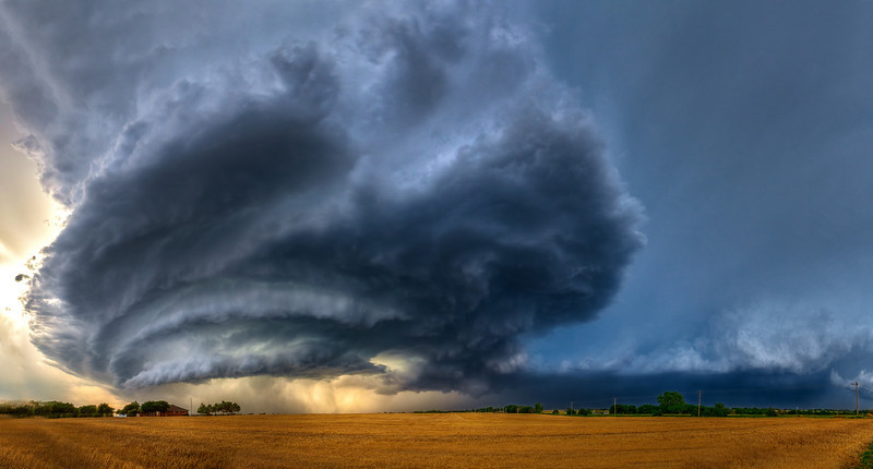
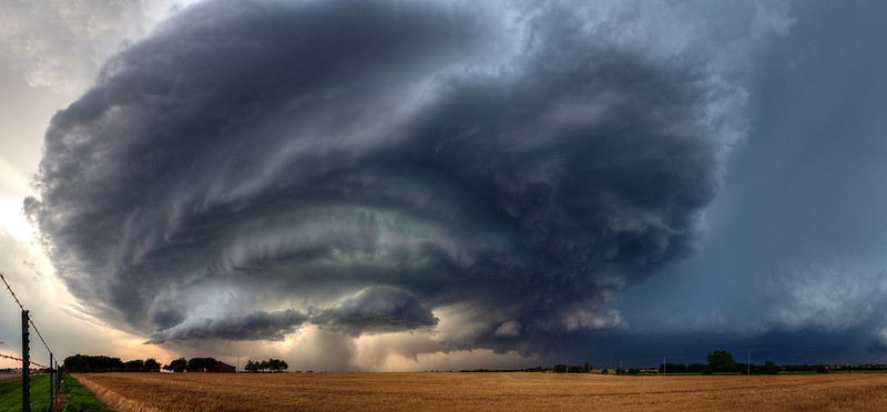
I didn't get the hail and tornadoes, but I did get a few pretty pictures. I started in Wichita, Kanas and targeted northwestern Oklahoma where isolated storms were likely to develop. I had a nice lunch in Pratt, Kanas and then dropped south and west to Waynoka. I started having difficulty with getting data as Verizon is terrible in northwestern Oklahoma. After Alva, I had no internet and was chasing off of ThreatNet. There was some development to my north and south, but I thought the better storm would be coming in from southwestern Kansas. I headed northwest to Buffalo and then north on a dirt road to intercept the storm. It was isolated and organizing nicely though high-based. I enjoyed having the whole road to myself to relax and take pictures. The storm was slowly moving southeast, and I expected more development as it moved into areas with higher dewpoints. I stopped briefly to photograph a brushfire that was started by lightning after calling 911. The storm developed some moderate rotation on radar but was unimpressive visually. I shifted south, passing the TIV. There were additional storms firing in line to my east but they were too far away to intercept and I didn't think they would produce very much as they were in a messy line. I had also spent too much time following my original storm. Eventually my storm died and I called it an evening. I had trouble finding a hotel room due to oil workers and various sporting events. I am now in Weatherford, Oklahoma on historic Route 66. I later found out that I missed some rain-wrapped tornadoes and grapefruit-sized hail near Oklahoma City, Oh well, I still enjoyed relaxing and watching my high-based supercell.

http://www.harkphoto.com/052912stormandroad.jpg

http://www.harkphoto.com/052912brushfire.jpg

Bill Hark
 
Good day all,

I was on the big supercells in Oklahoma today, May 29, and was able to see the weak tornadoes and finally the "gorilla" hail near Piedmont and tornado there. The hail alone could kill instantly if struck (reports up to 5")!

m13init1.jpg


Above: Convective initiation to the southeast of Alva, Oklahoma starts a great chase day of supercells. This developing supercell storm, in its cumulus stage, could be seen billowing upward into the sky.

m13rfoot.jpg


Above: Impressive rain "foot" associated with the downdrafts in the hail / rain core of a supercell near Nash, Oklahoma. Extreme wind (wet microburst) is denoted by the "curling" of the edge of the rain foot.

m13sc10.jpg


Above: Here is a picture (wide-angle) view of a developing tornadic supercell storm near Hennessey, Oklahoma with a large rotating wall cloud.

m13tor17.jpg


Above: Jeff Pitrowski and his wife were also watching the storm from the side of the highway (state road 51 near Hennessey) as it produces a brief tornado.

m13hail2.jpg


Above: Very large hail (called "gorilla" hail) falling near Piedmont, Oklahoma from another violent supercell storm.

m13tor18.jpg


Above: Here is a view of the developing tornado near Piedmont from the Piedmont supercell as it was dropping hail up to 5" in diameter!

m13hail1.jpg


Above: Here is an interesting hailstone I picked up near the Piedmont, OK supercell. This stone is about 3", and was actually one of the SMALLER stones!

m13tor19.jpg


Above: Low contrast view (rain wrapped) of the Piedmont tornado. From this vantage point, a low-pitched roar could be heard.

Full chase log along with others available here: http://www.sky-chaser.com/mwcl2012.htm#MAY19
 
Last edited by a moderator:
Targeted Canton (Oklahoma) and got on the cell from Initiation, followed this cell eastwards towards Hennessey, then south to Kingfisher and it finally produced a slender cone just South of Piedmont. Like Bill also called 911 when a cornfield went up in flames just 500 yards in front of us from a Cg Strike just South of Dover. Great day's Chasing on those Red Dirt roads!

Full Report and Pictures in the Link Below

http://forum.netweather.tv/topic/73401-supercell-and-tornado-photos-report-chase-day-20-oklahoma/
 
What a pleasant surprise yesterday turned out to be! The "Piedmont" storm was just west of my house so it made for a close to home chase. We chose to take Waterloo Rd west towards Okarche to hopefully avoid traffic. That turned out to be a great decision. It was as if we had the storm all to ourselves...no traffic. We had an amazing vantage point. As the storm dropped south we headed down county line road. Knowing the storm from the south was approaching we figured it would choke off the northern storm. After heading south we were beginning to get into the rain and small hail from the southern storm. So I grabbed a few more pics and headed home. Best decision I've made in awhile as we started hearing the reports of softball size hail! It was a fast, fun, relatively safe chase. I'm beginning to love those slight risks days! lol
 

Attachments

  • 028.jpg
    028.jpg
    10.5 KB · Views: 109
  • 032.jpg
    032.jpg
    13.5 KB · Views: 85
  • 037.jpg
    037.jpg
    12.8 KB · Views: 92
  • 040.jpg
    040.jpg
    5.7 KB · Views: 100
What a chase day this ended up being! I still have a ton of photos to process but wanted to get a quick report up before I forget the details.

I chased with my good friends Zack Biggs and Justin Terveen. We initially targetted the area near and North of Clinton, OK as the most likely point for storm initation. Overall shear looked great although low level shear was somewhat weak. Our first storm fired just south of Fairview, OK. We dropped south to highway 51 and moved to just East of OKeene to watch the cell is it quickly developed into a high based supercell. The entire armada of Project Rotate showed up a few minutes later as the storm developed strong rotation and a well defined wall cloud. The base of the storm was too high at this point for a tornado to form but it sure was amazing to see. Rather than core the storm we went south of 8 and East on 0720 towards Dover. We were able to stop periodically to shoot the beautiful structure of the storm. Still lots of rotation but still too high for any tornados that we saw. We continued to drop south eventually ending up just south of Kingfisher. We had a decision to make here as a very strong anticyclonic storm was coming up from the south and looked to intercept our cell. We made the decision to press on through Piedmont and managed to beat both cells to just south of town. It was there that we witnessed some of the most incredible structure I have ever seen in a storm as the southern storm crashed into the storm we had been chasing all day:

Early structure. I had to shoot this handheld due to the insane inflow winds. You can see the edge of the anticyclonic storm on the right side of the image:


I was finally able to get my tripod anchored for the following shot:


After about 10 minutes we noticed a beautiful elephant trunk tornado form back in the rain. I was videoing at the time:

Piedmont Tornado Video:
[video]http://www.langfordphotography.com/Storm-Chasing/2012/May-29th-2012/23261374_8bLpRF#!i=1876565420&k=tzPXJTT&lb=1&s=A[/video]

We avoided the insane hail and dropped south to 40. A new strong cell had formed just to our West and we were now kind of stuck. We decided to drop down highway 4 and take highway 9 back to 35 and home. Along the way we were able to stop and observe an incredible lightning lit updraft and wall cloud to our West which was found out later was producing the Union City tornado. We were able to beat the hail to I35 and drop south towards home.

All in all it was an excellent chase and one I will long remember!
 
Ian Livingston, Jason Foster and I drove up to Alva, OK for initiation. We tracked eastward south of the OK/KS border cell, watching it as the cluster of cells developed to the south. We eventually dropped south towards Enid, watching one of the middle cells for a bit as we worked back west. After some deliberation, we decided to drop south behind the storm that eventually dropped the Piedmont tornado and tracked it through its tornadic stage.

Watch video >

Go to the 1:00 mark for the tornado.

Edited video still:

https://p.twimg.com/AuHnsdeCQAAjElR.png:large

I still have some stuff to process... may add it onto this post later.
 
I headed up to Hennessey, OK right after work to catch a small cell to the west that I thought might develop into something decent, and since it was close I waited and watched for a half hour or so and I almost gave up on it to catch the more vigorous cell to the north near Enid. But, just as I headed back to town I noticed it intensifying suddenly and decided to stick with it and I'm glad I did. The structure on this beast was insane and the icing on the cake was the tornado near Northwest Expressway. Loved the slow storm motion, quite a satisfying chase.

246qp86.jpg


9a1zc2.jpg


29w32w4.jpg
 
We started the day and targeted Hennessy, Ok we went west from there to Okeene then north into Enid all the time watching the 3 storms the north one went up quickly. And seemed to attract the convergence we went north out of Okeene on highway 8. Then east on 412 into Enid. We then were caught up in a high speed chase and were delayed in catching the north storm so we dropped south towards Kingfisher we witnessed and called in several grass fires caused by lightning. Called in a tornado once outside of Kingfisher. And looking back to the northwest. We then headed east on east 890 road outside of Okarche and kept a constant eye on the storm got several more structure shots. Stopped for fuel at 192nd and highway 74. We then took a chance and headed south on lake Hefner parkway it began to catch us as traffic slowed. Traffic eventually stopped at the exit for Bethany the rain started to pick up then it started hailing then it got bigger there was nowhere to go. The wind then shifted on us and we had what we are pretty sure was a small tornado pass just ahead of us we were hit with flying debris. I decided and my friend in his vehicle decided we needed to get the heck out of dodge so we backed up turned around. We headed north bound in the south bound lanes exited on the on ramp onto northwest highway we then headed south west we split up. I headed towards the airport and he headed west to El Reno he intercepted a tornado at highway 81&.152 near union city and minco. I headed to the airport and then to Newcastle to intercept the same storm but from a different location. We both saw several tornadoes large hail and high winds and plenty of damage. My truck suffered several thousands in damage from jail and now needs a new windshield. But we're alive and okay my new mobile threat net worked flawlessly and it worked wonderfully while all of the other chasers were hung out to dry when the cell network crashed. ImageUploadedByTapatalk1338514161.560306.jpgImageUploadedByTapatalk1338514187.587939.jpgImageUploadedByTapatalk1338514200.184232.jpgImageUploadedByTapatalk1338514217.449205.jpg
 
little clip of the Piedmont tornado at the end. Will have complete chase logs and pics posted to the website in the next week or so including all spring tornadic chases we were on. I tried uploading some of my pics ,but I finally got a decent camera a canon rebel and the pics are to big I guess.

http://www.youtube.com/watch?v=e7KwgfO-qDM
 
Hi everyone,

Our chase tour group, with Brian Morganti, Keith Brown, and Woody Watson, intercepted the tornadic supercell near Piedmont, OK.

Chase summary and a few preliminary images are up on my site.

And, a minute or so of video as we headed south along Highway 4, with a view of the updraft base (and developing funnel cloud) to the west.

http://www.youtube.com/watch?v=W5raA922-9M&list=UUxHsdGq-slYR3OEzKb_2OOA&index=1&feature=plcp


William Reid
Westlake Village, CA
Tempest Tours
stormbruiser.com
KG6FWX
 
Was originally wanting to be in SW OK this day but worked my way North based mostly on what the HRRR was showing. Got on the cell near Okeene after watching it from a distance for a while. The rest of the time I stayed mostly right under the base as it drifted over Kingfisher and then down to Piedmont. Structure was fantastic and I was really too close to capture it even at 10mm. lots of spiraling cloud bands around this storm.
IMG_8159r.jpg

IMG_8162r.jpg

A little later…
IMG_8167r.jpg


Next image taken at about 7:00 is of a lowering with some obvious rotation. I figured a tornado warning would pop up any minute on this thing.
IMG_8175r.jpg


Next image is about 10 minutes later when a small tornado formed just to the North of me and headed SE. This was somewhere around Kingfisher. Notice the dust just to left of center. I put my still camera down and began filming the ground circulation which became tight and kicked up quite a bit more dust. Above this was a lot of scud with crazy motion and I noticed in my video that there is a laminar nub funnel rotating in there, so definitely a tornado. At the time I was thinking it might be a gustnado even though it was right under the base. Only lasted a few minutes.
IMG_8178r.jpg


Below is a contrast enhanced shot of the funnel/tornado? back in the rain SW of Piedmont. Photo was taken at 8:33 and I’m not sure if this is before or after (?) it took on the elephant trunk shape and touched down. All detail was soon lost in the rain. I was paying much more attention to just the overall storm structure… some crazy stuff going on at this time. I also noticed the roar when I was out taking photos of this but it seemed to me to be coming from more overhead and the vault area so I can’t say as I was actually hearing the tornado. That roar though is something else… lol… unsettling more so than the lightning wind and hail.
IMG_8188r.jpg


This is the first year I’ve used the HRRR on a chase to help in the decision making process and the four times I’ve used it so far…I’ve been impressed with how well it handles coverage and initiation.
Also I've driven through and chased in NW OK several times using millenicom and never been without data for long... maybe 30 minutes of you get back on some back roads. So I don't know why others have trouble with data. One thing that might help is I only keep up GRL3 and that is all that is updating plus I only have 3 products updating on that.
 
Last edited by a moderator:
What a great day! I chased with Fred Plowman, Gloria Surratt, and my sister Rita. We convoyed with Angie Norris for the first half of the chase. We left Norman, and stopped for some data at the Tee Pee pit stop near Geary along I-40, then continued towards Woodward. We then realized we were a bit too far west and had to haul east towards Alva and Enid. We managed to finally get on the supercell near Kingfisher and watched a rotating wall cloud. We got on a dirt road (it was dry) to stop and grab some pictures. A tight organized column of dirt spun up underneath the wall cloud, with a small funnel cloud above it. I think this is what Joshua Null is talking about in the above post... we were looking at it from opposite sides of each other.

May292012OKKingfisherwallcloud.jpg


We proceeded further south towards the OKC metro area west of Piedmont to view amazing supercell structure with well defined striations and banding. It is hard to tell in my photo (not blatantly obvious) but there is a fuzzy bulbous funnel hidden in the hail core, which a little bit later turned into more of a cone shape... think this was the tornado SW of Piedmont.

May292012OKPiedmontsupercell.jpg


May292012OKPiedmonttornado.jpg


Shortly after hearing reports of the Piedmont tornado, we left the storm to watch another supercell near Union City, which also had some nice structure.

May292012OKUnionCitySupercell1.jpg


May292012OKUnionCitySupercell2.jpg


After the sun set, we stuck with the storm and soon the meso passed overhead. We were between Union City and Minco when we heard on the radio (Gary England) that there were reports of a stovepipe tornado near the Canadian River. We happened to look behind us when we saw what they were talking about. It looked like it was churning up dirt and moving fast. Fred saw a funnel above it. Then the sides of it looked like a column going up towards the cloud base. Since it was on our tail, we did not want to take chances with safety, and bailed south into Minco, where the sirens were going off. I really tried to grab some pictures, but I accidentally had the stupid auto focus on and it would not take (grrr those dreams do come true!). We tried to find a sturdy building to hide behind, then realized we were okay and proceeded out of town. We could see what looked like a wall cloud but it was difficult to tell within the darkness and lightning flashes. Some say this was just a RFD plume, others say tornado... to me, it looked like it was rotating/churning and some video another person took shows a funnel above it, so who knows. I believe NWS OUN is investigating this. Still a great day!!!
 
Back
Top