• A friendly and periodic reminder of the rules we use for fostering high SNR and quality conversation and interaction at Stormtrack: Forum rules

    P.S. - Nothing specific happened to prompt this message! No one is in trouble, there are no flame wars in effect, nor any inappropriate conversation ongoing. This is being posted sitewide as a casual refresher.

2012-04-30 REPORTS: TX., OK., KS.

Joined
Jul 17, 2004
Messages
381
Location
Piedmont, OK
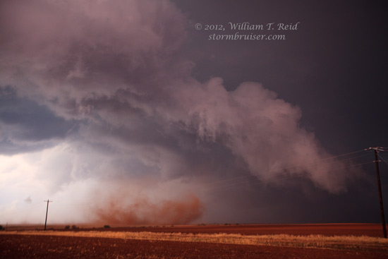
Initially I wasn't going to chase today due to work constraints but getting off early made me think twice. I initially was targeting the Hollis area in SW OK. but turns out I had to head well into the TX. PH in order to have any chance of seeing anything decent. Thanks to Roger Hill and Dave Ewoldt for that suggestion. I left OKC at 3:30 and made it to Clarendon around 3 hours later where I witnessed the supercell that at times threatened to produce. At first it looked like a normal shelf type cloud feature and almost bailed on it but then wrapped up nice with moderate rotation and decent structure to boot. I stayed in front of it until close to Memphis where it started gusting out.. the attendant OFB was stout, kicking up huge plumes of dust all around me at dusk as I headed SE out of Memphis. It was quite a foreboding site and the dust was thick heading down the highway.. at one point as I traveled at almost 60 mph.. ground debris including tumbleweeds were actually flying past me with the wind behind me. I estimated winds close to 70 mph at that point, then suddenly the winds blasted out of the south for a few moments and visibility went to zero.. probably only a gustnado but those moments made the navel pucker. Hearing reports of flooded roads around Wellington and north of Clarendon not to mention the damaging hail that potentially would have made mince meat out of my car, made me decide to go down past Childress to Quanah then go north to Eldorado, OK. to try to get in front of the storms and beat them back to Altus and Lawton.. no such luck.. I made it to Eldorado where an intense and VERY electrified thunderstorm greeted me. Thankfully, my good friend Dave Ewoldt was on the phone with me through most of the event as I found some semblance of shelter against the local police department's building (which was vacated).. tennis ball size hail was a threat along with who knows what else that storm had in mind.. thankfully, all I saw were quarters and winds to about 50-60 mph. Finally, I let the storm pass and was treated to quite a lightning show most of the way home.. which I arrived just after 3am.. All in all, glad I went out.. but what I think was an allsup's burrito in Clarendon yesterday had the stomach in knots..Below is a link to some pictures I took around Clarendon. Thanks to Roger Hill, Ray Walker, Charles Edwards and Dave Ewoldt for timely updates.

http://www.facebook....=1&l=0895f8ac65
 
Chased storms North of Dodge City got on the storm soon after it developed, it started to rotate looked like it would put down a Tornado at any time. Had to keep moving East to stay out of the circulation saw a few brief funnels, before it started to get rain wrapped. As it was getting wrapped in rain a very large funnel started down, but visibility made it very hard to see if it reached the ground. After that could not make out anything behind the rain. Got off that storm and moved SE to a new storm that had a nice rain free base, and watch it start to rotate and then get rain wrapped. Ended up in Greensberg at sunset to watch a third storm with rotation pass over town then shot some lightning after dark. Did not get a lot of pictures of the storms was streaming video and was more focused on doing that then taking pictures, but here is link to what I have. http://www.flickr.com/photos/27494159@N04/sets/72157629937992279/.
 
I was lucky to get off work right at 5pm; I left the TTUHSC campus (west Amarillo, TX) and headed east on I-40 thinking that the Childress area had great potential from the RUC models earlier in the day. However, I noticed the storms which had already fired west of Amarillo were all fading in intensity except the one south of town (north of Canyon near the Lake Tanglewood area). Decided to take a detour and head south on the loop to the Claude Hwy which led me to the outskirts of the intensifying hail core. From that point I just stayed out ahead of the storm; once I found myself in Claude I noticed 287 was perfect to just skip from stop to stop and keep in front of the storm. By time the storm was approaching Clarendon, it began to show a decent couplet on velocity scans and decided I needed to get out of town quick. Thankfully Hwy 70 south provided me a south option as I noticed a progressively more southeastward movement with the storm. Since visibility was degrading rapidly I decided to stop and enjoy the lightning show for a bit and then headed back to Amarillo. On my way back through Clarendon and along 287 (northwest) there were numerous trucks and vehicles pulled off the Hwy with what appeared to be some serious hail damage. http://www.facebook.com/media/set/?set=a.3609256717446.159809.1454552675&type=1&l=2f850e8086

Chris Adkins
 
I got a late start last night and didn't hit the road til after 6:30pm, but I was able to get down to Wellington, Tx and get in front of the storm before it decided to pick up speed. I followed it east for a good bit after dark, eventually deciding to call it quits when there was a break in line of storms near Willow, OK. Unfortunately, I forgot to load my tripod for the low light conditions so the images have a bit of camera shake in them.


sawjll.jpg


xomet1.jpg
 
Started in Amarillo and watched the storm skirt south of town and towards Claude. Witnessed some walnut sized hail in Claude. Even took one in the shoulder as I grabbed this sample! Followed the storm southeast on 287 before bailing out when it went outflow dominant near Lelia Lake. Not a bad local chase.

102_6711.JPG

102_6727.JPG
 
I started the day off targeting the area between Clarendon and Silverton and after resisting the urge to blast north to the Amarillo storms I finally got under a decent tower near Silverton that showed promise for a few minutes.

IMG_0301_small.jpg


After watching it fall flat I noticed a storm had gone up between Clarendon and Silverton so I blasted northeast through the canyon to get a closer look.

IMG_0309_small.jpg


After arriving on the storm and following behind the core I came across hail ranging from golf ball to a few tennis balls in Clarendon. After the storm crossed 287 I stair stepped my way around the storm as it produced a well defined wall cloud with decent rotation. Ultimately I ended up right next to Bill and his crew and witnessed the same brief tornado that eventually crossed 83 before lifting.

IMG_0359_small.jpg


I followed the storm east to Hollis where it maintained a well defined wall cloud but never managed to produce (at least that I witnessed). All in all a great day in the panhandle.

I would also add that I saw no reports of this tornado and decided against reporting myself because I was unsure at the time that it was in fact a tornado. Bill's video solidifies exactly what I suspected but the slow disorganized rotation had me (and clearly others) second guessing. Glad someone else documented this.
 
Last edited by a moderator:
I would also add that I saw no reports of this tornado and decided against reporting myself because I was unsure at the time that it was in fact a tornado. Bill's video solidifies exactly what I suspected but the slow disorganized rotation had me (and clearly others) second guessing. Glad someone else documented this.

I had the same questions as well when I was watching it. At the time I didn't think I was looking at a tornado but I knew it was something I didn't want to stay in the way of. Thanks to Bill for that video, excellent job.
 
NWS Amarillo viewed the available images and video and determined that this is a legitimate tornado. The radar image on their web site shows a nice hook and couplet!

I provided to NWS AMA my estimated position while shooting the storm south of Wellington. My "guess" of 7 miles south of Wellington appears to fit the radar image. Brandon and/or Sean --- if you know exactly where we were, please let me know!

Bill
[email protected]
 
Had my best chase of 2012 and one of the better catches of my career on Monday up in Grant County Oklahoma. I observed 2 tornadoes including one very photogenic and long-lasting one near Medford, OK. I got some of the best pictures of my career and well after dark! My Canon 60D was an excellent investment as it allowed me to easily take long exposure pictures capturing the tornado in lightning strikes and front-lit by the gas plant in Medford.

Watch video >


20120501-IMG_4381.jpg

20120501-IMG_4404.jpg

20120501-IMG_4436.jpg


You can view my photo album at http://www.benholcomb.com/photos/stormchasing/20120430

I've done a full write up at http://www.benholcomb.com/Chase-Accounts/20120430
 
Back
Top