11/27/05 Reports: Central/Eastern Plains

Joined
May 5, 2004
Messages
245
Location
Owasso, OK
Chase Target: Chanute KS

Brief version.....

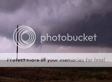
I was accompanied by Joseph Tyree and Mike Gauldin. I was orginally with Steve Miller(OK) and Bob Hall, but we were seperated in the middle of the chase. We caught three tornadoes in Neosho Co. Kansas. They were all front lit with red dirt. Pics when we get home.


Photo by Philip Daake
redtornado.jpg


Video here
.mpg]http://www.stormguy.com/site/images/zoom/X...Tornado1[1].mpg
 
Tornado was located just north of Erie, KS. It was haulin' (est 50-55mph). I tell you what, chasing on the Sunday after Thanksgiving sucks, there was a TON of people cloggin the roads.
 
My First Daytime Tornado!!

I went out this afternoon, thinking that if I was extremely lucky a tornado might catch me, instead of the other way around. Most of the tornado warnings were occurring in Montgomery and Neosho counties in Kansas. I decided to head for a target area of Walnut, Kansas, just to see what might happen. Tornado warned storms had already zipped north by the time I had gotten to Walnut, so I decided to hang tight and I found a great hilltop vantage point on Kansas 146 highway and Udall Road (must have been a good sign).

Another very fast moving storm had been tornado warned in southern Neosho County, Kansas, and I couldn't have had a better view of the storm from my location. The storm was reported to be moving north at 50-55 MPH. The storm had a wallcloud with it from the time I first saw it to the time it moved north of my location. When the tornado warned storm moved to about three miles southwest of my location, a debris cloud formed on the ground. I witnessed my first daytime tornado at 1600 hours today. I witnessed the tornado on the ground for approximately five minutes as it raced north. I finally lost sight of it moved north of Highway 146.

I did get some great still photos and video of the tornado. I also checked the area for damage, and unfortunately a house was destroyed 1 mile South of Highway 146 and Rooks Road in Neosho County. An old combine also had been overturned in a hay meadow in this area.

Link To My Website With Photos and Chase Account
http://www.seksweather.com/20051127ErieKsTornado.html


Looking Southwest At Tornado, Which Was Currently Located Northeast Of Erie, Kansas.

148_1024.ts1133136878395.jpg


Looking West As Tornado Crossed Kansas Highway 146 And Grows In Size.

155_1024.ts1133136902723.jpg


Looking West-Northwest At Tornado. This Was At It's Mature Stage, Before It Started Getting Smaller.

158_1024.ts1133136915661.jpg


Looking At A House That Was Partially Destroyed As A Result Of This Tornado Located 1 Mile South Of Kansas Highway 146 On Rooks Road.

171_1024.ts1133136927676.jpg
 
Great shots!

Debated for quite a while this morning on whether I would rather work ahead of the bulge in the DL in southeast Kansas, or instead play in the colder environment closer to and north of the surface low. Started to worry about the speed of storms in the southern target, so finally decided to hope for slower storms closer to the low and headed west on I-70 at about 12:30 p.m. as the first watch was being issued. West of Topeka I started getting reports of the storm south of Jct City becoming tor-warned, but as I got closer to Junction City, another cell began developing to the southeast of the original storm which was a lot closer. So I headed south on 177, where I intercepted a nicely structured supercell with wall cloud that produced several funnels - could not make a positive confirmation of anything on the ground at this point, but very well could have been (there was some wild inflow rocking me on the south side of this cell) ... followed it north through Manhattan and on the other side of the resevoir, where another tornado was reported by law enforcement. Could not verify this from my location, but as I turned to head back east and then south, saw what looked like a tornado (or else the most clever look-alike I've ever seen) a few minutes after the warning expired in Riley/Pottawatomie County. If anyone else saw this, I would like to compare notes. Ended up getting some pretty decent shots of it somehow (wild colors and contrasts going on - what a sky!) ... great rainbow too. Thanks to both Scott Currens and Darin Brunin/Dick McGowen for their thoughts today -

SE Junction City -
WEBKS112705Ks0007.jpg
Funnel -
webKS112705Ks0008.jpg


Pottawatomie Co. -
webKS112705Ks0108.jpg
webS112705Ks0101a.jpg


webKS112705Ks0029.jpg
webKS112705Ks0093.jpg


Kansas City is currently experiencing 60 mph surface winds associated with the frontal boundary and disassociated from storm activity. I can imagine the kind of damage this is going to do to the area by morning. Really anxious to see Brunin and McGowen's photos, as their catch sounded pretty spectacular -
 
Jay Cazel's and my report...
I was planning on riding with Jay Cazel today because I had turned off XM for the year and I lost all my external antennas during Rita so most of my equipment isn't working right now. Jay had some problems getting away from the wife so I ended up heading out by myself at the last minute. By the time I got to ElDorado, Jay called and said he was coming now so I stopped and waited for him. After he caught up to me, I jumped in his car and we headed East for Iola. We intercepted the storm in Neosho county and saw the tornado North of Erie. We were about 5 miles North of the tornado and driving when these pictures(actually video grabs) were taken so they are kind of blurry.


my.php
[/url][/img]


my.php
[/url][/img]


my.php
[/url][/img]

Even though the tornado was weak, you can't ask for more considering it's November 27. Congratulations to everybody else who was on the tornadoes today.
 
Left work at 2pm, not sure where I'd attempt to chase until seeing radar developments during the previous hour. The cells/environment northeast of McPherson was tempting, but there was a whole lot of rain between them and I.. not to mention uncertanties regarding destabilization downstream of these cells. More convection was building southeastward from there and it looked like I could maybe intercept one of the southernmost cells in Franklin county. So I planned to head for Ottawa and drop south from there if need be. By the time I reached Overland Park these cells had formed a solid line, so I turned south on 69 (while realizing my window of opportunity--daylight--was going to be even smaller).. hoping for isolated supercells to mature farther to the south. After eventually passing by a weakening cell east of Iola (I think), I was lucky to get in position for the Neosho county cell as it gasped its last breaths. Here are some pics taken from near 39 & 3 in southwest Bourbon county... looking southwest and then west-southwest in the 6-8 minutes up till tornadogenesis in the Erie vicinity. http://www.tornadohead.com/chases/112705.htm
 
First of all thank you Eric B' Hymer, Stewart Manning, and Roger Schwartz for your great nowcasting today.

Also, a huge thanks to Jon Davies as well. Your cold core studies are amazing and really made all the difference today.

What a day....awesome to say the least. The photos are Dick's and mine put together.

Dick McGowan and I left Lawrence with the same decision as Mike and Scott of to chase north or south. We got to Topeka and eventually decided to get the best of both deciding to head towards Emporia. We received word that a storm had fired on the Butler/Sedgewick Co. line and had heard that it was the best looking storm at that time. We calculated that we would meet up with the storm in an hour in Marion Co. Upon arriving and seeing the base we were pretty excited as a couple roping funnels form. It was just about that time that we saw a storm to the southeast go up and disrupt our storm with outflow. Knowing this was probably the end of that storm we decided that we were going to play the southeast storm. In the process of doing that we looked back at the old storm and were shocked when the base had a good rotating wall cloud on it. Shorty after the first tornado of the day formed and was very photogenic. It sometimes had two vortices on the ground at the same time. We let it pass within 1/4-1/2 of a mile of us and then started following the meso north as the tornado lifted. Keep in mind that the road network in the Flint Hills is not good at all. We soon fell behind the storm and watched it put down another tornado to our northwest while we were perched on top of a hill. This tornado was probably 3 or 4 miles to our north and was probably the least photogenic of the day although in person it was a sight to see. It reminded me of the Rooks Co. KS tornado on June 9. While this tornado was roping out we just happened to look to our east and see another healthy updraft with yet another ominous wall cloud on it. Soon after we saw tornado #3 on the day. This tornado touched down off and on for a couple minutes but then got its act together and formed into a big cone. After this the tornado lifted the road network really got us in a bind and we coule never fully recover. We then proceeded to go up Highway 77 to Junction City briefly seeing one more wall cloud but it was just too far out ahead of us. We broke off and then were treated on our way home with a spectacular mammatus display as we rushed to make my TV stations 5:30 news.

All in all....What more could you ask for? Great structure, photogenic tornadoes, and beautiful scenery. Is it really November 27?

Some of these are a little blurry...I apologize
First touchdown(vid capture)
1105079.jpg


getting ready to cross the road
11272.jpg


roping out
DSCF0019.jpg


tornado #2 forms
11276.jpg


close up vid grab....contrast enhanced. I hate my camcorder ;)
1105090.jpg


tornado 3 then forms to our east
11275.jpg


Then after a few minutes it gets a lot wider(vid grab - enhanced)
1105118.jpg


DB
 
I should note that my sister called me when that first tornado touched down, and told me that a tornado was forming DIRECTLY over her (Coincidentally.. She then asked me what to do, and my cell went out. I finally got ahold of her an hour or so later and I guess she watched the second one form over to her east *second tornado* She was heading home from her boyfriend's house in western kansas. sigh.

Here's the one's she's talking about :

11271.jpg


11273.jpg


I will post more pictures in my blog tomorrow.
 
Congrats to all who saw excitement today.

My account is short... sat east of Scammon Kansas to watch storms come into Crawford County, the storm was disorganized, weak, and only watched rain shaft. Tornado warning was cancelled shortly after it was issued.
 
I observed 4-7 tornadoes from Delavan, KS to near Junction City, KS. The first was a beautiful high contrast rope tornado. As the first tornado dissipated a new meso formed 1/4 mile form my location. I followed this meso north for nearly and hour as it produced several tornadoes.

Edit: After reviewing the video it is clear to me that the second meso produced a single long-track tornado that traveled 21 miles in 34 minutes. This tornado had violent motion just above the surface, but for some reason couldn’t bring it down to the ground. At the surface the tornado never looked any stronger than a strong F1.


05-11-27%2001.jpg

Tornado #1

Grabbed%20Frame%2018.jpg

Tornado #2 at its peak intensity.

Short video clip:
http://www.violentplains.com/video/05-11-27.wmv

Scott Currens
 
Here was some of the hail we ran in to. Nothing great, don't think any of it was bigger than pea-dime size.

Img_0032.jpg
 
Here is my short and late contribution.
I left Tulsa and headed north on 169 , deciding I needed the extra east position of 169 vs. hwy 75 due to the faster movement of the storms that where forming. This worked out since by the time I was reaching the border south of Coffeyville Kansas so was the warned storm. I was able to follow up 169 behind it . I missed the reported touchdown (?)around Cherryvale ... I found myself farther north than I had planned so as I headed east and had just come into the town of Shaw a new warning came out for a storm to my south. After determining where the storm was reported and where I was on the map, my first thought was perfect!!! If timing worked I could keep heading east while stopping every once in awhile to take photo's. All seemed to be working fine but as it got closer the best action happened behind me while I was driving east on 146 to the next road north , so I missed the best photo op's. 146 offered no place to pull off safely to get out , except for where Russel Parsons was who got this photo of me driving with the tornado in the background(pretty cool pic to me anyway) . Anyway I ended up going driving north behind it and was able to capture the tornado for a few miles but it didn't pick up as much dirt like it did around the 146 area.. It was still a great day and enjoyable and without breaking any speed limits ....

Coffeyville
ksimg0021.jpg


Between Coffeyville and Cherryvale
ksimg0022.jpg.w300h225.jpg


Erie storm
ksimg0049.jpg


North of 146
ksimg0059.jpg


and off to Missouri they go
ksimg0084.jpg


More pic's here http://stormdriven.com/112705.html
Video's Coffeyville & Cherryvale / Erie area
 
Back
Top