06/08/05 REPORTS: Central Plains

Status
Not open for further replies.
Joined
Dec 8, 2003
Messages
2,208
Location
Kansas City, Missouri
EDIT - reports coming in now of at least two touchdowns very early on with this storm ... apparently just before we arrived under the base, dang it ... Roger Hill even reports one multi-vortex tornado that became a truncated cone at 5:07 (as we were struggling to get through traffic in Leavenworth) ... another soon-to-be Stormtrack member, Andrew Lee, has emailed me and mentioned that he was also on the Oskaloosa tor ... Congratulations to all on the catches tonight - I knew we should have been out the door earlier!

----------------------------------------

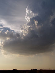
Disappointing but beautiful chase tonight. We were on the Leavenworth/Jefferson Co. storm. We arrived under the base in the city of Leavenworth just as the tor-warning was being called on the cell. Leavenworth is the worst town on the earth to try to get through in a hurry. The storm sat over the hills and trees just west of the river and messed around for the longest time. We were about 5 mi. east of Oskaloosa when reports were coming in of a sighted tornado ... if there was one, we sure didn't see it. We swung south on the storm as it back-built in a nearly stationary position. There was some decent rotation initially ... in fact I'll post a pic of a nice rotating lowering and a funnel or two (wonder if this was what Jonny R. was getting in the copter actually ... he was flying above us quite a bit today). As we turned around to leave realized that Jeff P had been right behind us watching it the whole time as well. Made me feel like we were in a good spot at least. At times notches would develop and form horseshoes in the inflow as the storm would struggle to balance and form some sort of RFD, but no well-defined RFD could really get established ... and this storm remained highly elevated during almost its entire lifespan that we observed, forcing us to continue moving south and west as our position would gradually get downdraft and the storm backbuilt. This was the first time in a long time that I was turned around with my directions while watching this storm ... the storm motion kept throwing me way off.

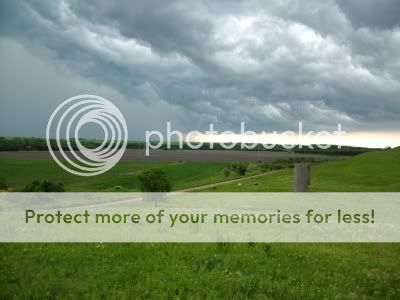
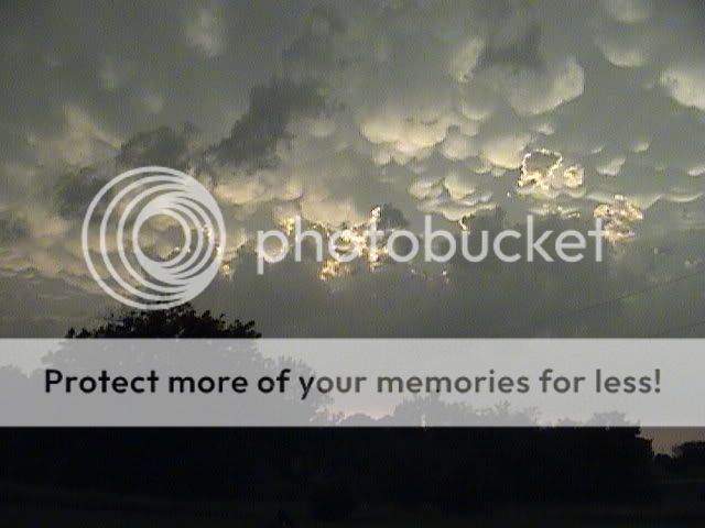
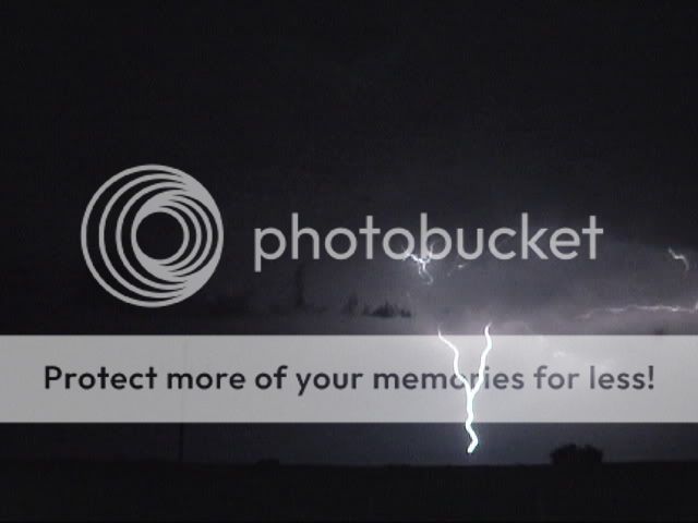
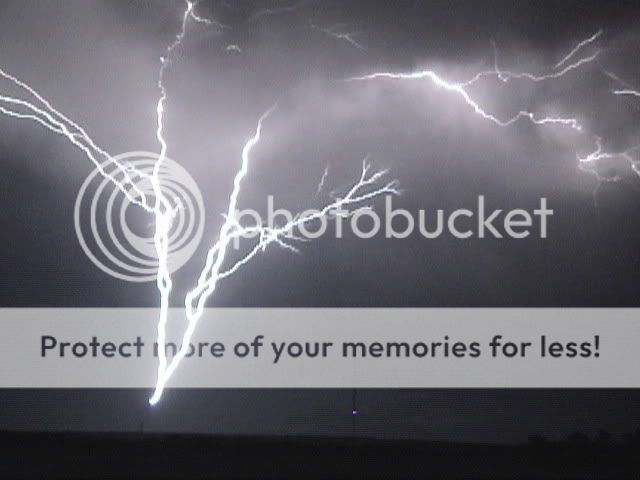
Now the best show was after the storm finally started moving east ... great gust front in KCK by Cabellas kicked a wall of dirt into the air ... wow - very cool. And then the fireworks started. Got some really neat lightning shots tonight. And this was the most stunning sunset I've seen in a long time ... going to have to spend a lot of time editing pics, I think. Took about a couple hundred of lightning at least -

I'll post a link to the sunset/lightning pics whenever I finally get a chance to work on 'em.

webLeavenworth1.jpg
webLeavenworth2.jpg


Couple of the sunset - neater ones later -

sunsetweb.jpg
webLeavenworthsunset.jpg
 
What a day. Started in Emporia. When things started looking better to the north, I made my way up to Lawrence. Then a bunch of stuff went up. Couldn't really decide, so I headed down towards Ottawa (missing the action north of Lawrence by no more than 5-10 minutes), and then meandered in the direction of Lyndon, where I figured I could intercept what initially was moving NE from back where I started the day. I know Tim V's book says "stay faithful your target," but I'll probably make this mistake a few more times before it sinks in. :? Anyway, I camped out under a giant shelf cloud for a while. A tornado warning came out for Admire, and it was close, so I headed over just in time to see and anemic wall cloud get swallowed up in outflow. After that, it was all heavy rain, small hail, and some pretty serious straight-line winds. Not the best day, but not all that bad cither, considering the last wall cloud l saw was a year ago.
 
I see there are two threads for the same day/region (???), but will reply to this one because it was there first.

I chased in central MO today; got occasional peeks at outflow-dominant storms through gaps in the trees. Oh, wait a minute - you know that, since I already said I chased in Missouri. :!:

I headed out too late due to stuff that came up at work, but still figured I would see something in the way of storms, and if I could get far enough west into the extremely unstable air in central and especially western MO, I might see something fairly interesting. Figured I could get at least as far west as COU and maybe a little farther, and did. However, the outflow pushed the storms on a more southeasterly course than I initially thought/hoped, and I had to bail off I-70 and cut SW to Fulton on route Z to avoid (sort of) getting cored. Got through Fulton a minute or two before the 1-inch hail hit there; did not encounter any hail, thankfully, but did get some estimated 40-50 mph gusts and wind-driven rain along the gust front.

Dropped south to Jefferson City then went west on 50 to California to try to intercept the tail-end storm - not sure if I had it or not, but was close. Watched another hailer pass just NE of California and got some nice shelf cloud shots as I stood in the northeasterly/easterly winds created as the outflow seemed to deflect westward off the southerly/SSE inflow to the south. A problem with these storms was that the gust front/outflow boundary kept pushing south of the main convection. I could occasionally get ahead of it by moving south or west, but not for long - and the outflow ahead of the storms kept much in the way of rotation from being a possibility.

Another storm went up NW of California. At first it had a lowering under the updraft that looked a little like a wall cloud, but almost immediately it became elongated and turned into a shelf cloud. Seemed to be the story of the day. Even though the storms in central MO produced more in the way of hail (mostly .88 to 1.25) than wind (which was more common farther east, near STL), they had a very outflow-dominant character to them, so never really got close to producing a tornado. But with CAPE predicted at 5000 or higher, you kinda gotta try!
 
Well...Got off to a late start today. However that did'nt deter me from seeing some decent action. Heading west on 40 hwy in wyanndote county I had to hide from some quarter to half dollar size hail. I decided to make my way south to get out the core when the whole thing started to bow out. At 69 hwy and I-435 I experienced at least 70-90 mph winds. It was quite a show. The amount of misc trash and such blowing around was very strange. I continued east a bit to see it die out. I thought it was a good day as I have not witnessed wind that strong in a long time. A special thanks to Mike Johnston, Dick, and my brother for nowcasting for me. 8)
 
Left Wichita towards 2pm this afternoon in route to the Yates Center area. Arrived in Yates Center greeted by towering TCU near the Emporia-Ottawa areas. Went north out of Yates Center and watched the original first svr warned cell form E of Emporia. Originally, the storm took on somewhat of a supercell characteristic before other storms blew up around it and made it more linear/cluster over the next hr or so. Watched the storm near the Milford Lake area for a while, with bad road options and quite flodded roads abound. Over the next hr, it was very evident per radar/observation the storm was building back towards the NW near the boundry. Decided best shot was to head west towards N of Emporia for a possible landspout type event. A tornado warning was issued for N Lyon county for a time, observed a fairly well-defined lowering/wall cloud with some rotation NNE of Emporia. Soon after, found out that previous storm I was on W of Ottawa was now TOR warned as well.. !!. Decided my storm/area was a no go, considering low-visibility terrain/severe flood potential. I decided to blast south of 35 towards the more isolated storms NE of ICT which were currently svr warned however showing some rotation. Finally arrived in El Dorado shortly after 8:30pm and observed the storm NE of ICT that was TOR warned. Previous reports over the radio were indicating several small brief funnels/defined wall clouds had been observed the last half hour. Approached the storm from the E to be greeted by a rotating wall cloud SE of Newton, KS. Wall cloud was organized for a short while before dissipating. Continued towards 35, turned onto 35-S and observed a later very well defined wall cloud/possible short lived funnel from E of Valley Center, KS.

Storms are currently causing major flood problems in Harvey/N Sedgwick counties here in KS. At my house in SE ICT, I have recieved 0.00 in the rain bucket.

A typical high-cape/boundry/low-shear day
 
Today was the second could've been, should've been, woulda been in a row for me. Started out from Lawrence with an initial target of Atchison, KS. Once I got to Atchison a storm fired but soon fizzled out as it crossed into the air that the MCS in MO recently moved through though. I was thinking that maybe an outflow boundary from that MCS would have helped out that storm but it didn't prove to be correct till a few hours later with the eventual tornadic storm. In a dicey move I decided to head back south towards Lawrence as there was a decent line of Cu forming from Topeka to Emporia. I sat at Perry and watched the eventual tornadic storm form although for the longest time (until I left it) it didn't look promising. I then headed south to Ottawa and met up with Dick McGowan who was with Eric B'Hymer and Fred Plowman. We then got word of the storm going up to our southwest in southwest Osage Co.

Storm as we approached it on I-35
pic4.jpg


After getting to Osage City there was a wall cloud with slight rotation but it soon went outflow dominant and the all too familiar whales mouth formed.
pic3.jpg


After this a storm in NE Lyon Co. had a tornado warning for it issued and I jetted west and caught a glimpse of the base but it was soon undercut by outflow.

Then I tried to decide whether to enter the ghetto or the wild wild west as I came to the intersection of 8 mile and Bronc Rider Road.
pic5.jpg


Soon after the day was certain to be a bust as everything went linear. But the sunset was awesome.
pic2.jpg


Then the amazing lightning show started and I took pics for a while. A couple....
pic1.jpg
pic6.jpg


All in all no tornadoes but got to meet some good people and the atmosphere provided other treats than tornadoes. I should have waited a llittle bit longer for the outflow boundary to do its job.

.
 
Well, not much chasing for me yesterday as I had some family obligations to fulfill. Of course as soon as they were fulfilled I was out the door!

More of a lightning chase for me, and boy you didn't have to look far. Last night was amazing. We wound up SE of Wamego for about three hours, and I would have been out there for another two or three if my wife and her sister hadn't fallen asleep in the back of the Jeep.

Just about every tower within line of sight took at least three hits last night! Amazing show! Looks like a promising next few days as well......the thunder has been rattling my office window all morning :D

Tim

June8006.jpg


June8032.jpg


June8040.jpg


June8024.jpg
 
Left work in Iola, KS at 6:52 and headed north. As I approached Ottawa, KS from the south I could see a nicely rotating Sup that was west of town. The storm went tor warned at that time. It had nice inflow and was wrapping up quite nicely. I was able to catch up to a rather "tall" wall cloud on the northwest part of Ottawa as the storm was moving east. I chased it on Hwy 68 for a couple of miles but just like everyone else's reports it quickly got swallowed up by outflow. It was a nice catch for me on a day that I had no intentions of chasing. Heck, I was actually just heading home from work.
 
I left Pittsburg about 5:30 and headed towards Greenwood county to wait for storm intiation along the front.

At one time the storm in Butler Co had rotation to it and became tornadic, the storm was moving NW so my plan was to head into the NW part of Greenwood and intercept it from the south.

I made my way into the far northwest corner of Greenwood county and positioned myself directly east of a small town called Cassody.

By the time the storm approached to my north it had lost it's much of it's rotation, but the view we had was friggin' awesome! We were high up on a hill with nothing but flat green land all around.

This monstrous storm had an awesome shelf cloud that stretched to the horizon with blinding rain falling beneath it blocking any view we'd have of a torando.

By this time though it was nearing dark. Up overhead we had the anvil stretching across the sky that had very beautiful mammatus clouds that just hung down....

After about 45 minutes of watching the storm we headed west into Cassody where we then took 177 south back to highway 54 to get out of the path of the storm due to reports of golfball size hail.

The storm was amazing, if only it could had been like 1:00 in the afternoon instead of in the evening...

All in all, we didn't encounter any hail, just heavy rains, strong winds, and an awesome view of the storm as it passed.

It was definately an awesome chase

My pictures came out like crap, here is the best 3 pics I got...

june9_1.jpg

june9_2.jpg

june9_3.jpg
 
06/08/05

What I witnessed on 06/08/05:
1. Beautiful shelf cloud
2. Winds gusting to over 60 mph
3. Dirt plumes being kicked up along and behind shelf cloud

Where?
Blackhawk and Benton Counties, Iowa.
 
Report: S & E Kansas

At about 4:30 pm, approximately 45 miles N. of Wichita, we watch a towering cumulus deck suddenly turn on a switch and explode just to the East of I-35. It's truly a spectacular sight, and within 20 minutes it becomes warned with large hail and damaging winds.
We persue it, and about 25 miles N. of Emporia we stop to watch the ragged rain free base at it's rear for the development of wall clouds. It does produce 3 brief tiny finger-like funnels suspended up inside of an updraft region. It also produces delightful cooling scents of fresh rain and earth.
Continuing NE, KS 130 takes us right up to the heart of the storm. During our approach we delight to the black sky contrasted with brilliant C-G's and the development of a growing wall cloud to our NW.
When we arrive to this area, we watch the wall cloud spinning low above our heads within about 1/2 mile to our NW; it's bottom pointing in our direction.
With awe and astonishment, we look up into a rotor of spinning blacks and swirling brighter grays. A moving arc of dark cloud angles into the rotor from it's south and east sides, meeting the rotor along it's north side.
Several other storm chasers pull over at this intersection to watch along with us.
Within about 10 minutes the storm goes completely linear.
The NWS calls a tornado warning for storm to it's west just west of 335. We spring for that one, and do see a neat wall cloud that looks like an isolated silvery skirt silhouetted upon a dark background.
Despite an additional tornado warning back off to the East, everything quickly goes linear, and our attention now focuses to the profoundly beautiful and spectacular lightning show that lasts well into the night, along with intensely heavy rains.
 
Status
Not open for further replies.
Back
Top