Doug_Kiesling
Chased in north central Kansas.
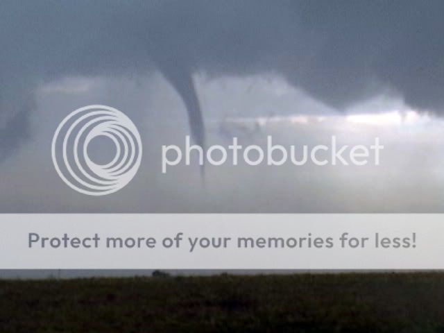
Got the Hanover KS Tornado.

Got the Hanover KS Tornado.

 Pics and Account Now Up At ) http://www.stormchaserdan.com/cyclone_dan_2006_photos.htm


") Shawna Helt
Shawna Helt Man, that's quite a sight, looking straight up 40,000 feet, and seeing the base right above and the knuckles peeking out in the stratosphere and everything moving in different directions. Hope everyone in Clay Center came out of this one okay.


 Anyway I'm sitting here about 6:00 at the house and David Douglas calls and says are you watching the Burnett storm, and I say 'What?'. Anyway about the only cell in TX (pretty large and severe warned) formed just northwest of my house in Cedar Park. I could look out my back window and see it. I had been watching all the northern stuff on radar at the time. Anyway I decided to throw all the stuff in the car and take a leisurely trip up (about 5 to 10 miles) to this apparent hail storm. This was the quickest I ever left because the vehicle is all set up. Just pick up a few things and walk out. Plugged some stuff in and away. Shot up to Liberty Hill near what is called Seward Junction where now on Threatnet the one cell had split into 3. The one in the back for awhile was indicating 3" hail. I moved around a bit trying to find the best place to watch. Finally I found a good spot on a hill just west of hwy 183 as the sun was just above the horizon with storm in foreground slightly oriented to south of due west. It was slowly approaching. I was watching the very intense light gray core just obviously dumping rain and hail. However suddenly just to the left of that feature and emerging from it I could see a much darker feature shaped basically like a cylinder and it was all the way on the ground. I was saying 'No way, it can't be'. I must have said that several times to my self along with 'What the!'. As seconds and a minute or so passed the feature got further away from the precip core and at the bottom it appeared to have swirling precipitation. This whole thing was estimated 7 to 10 miles (5 at the closest) away. I thought I could see small vortices at the ground level swirling, but it also appeared to be violent motion. I went from almost falling asleep to adrenalin pumping. I was on the phone with Bill Combes who was on his way up from my southeast but he was still pretty distant and couldn't see that area yet. It looked so possibly believable that it made me worried as it approached the urban area so I decided I better call it in - which I did. I'm sure the guy thought I was nuts. I don't think it was showing much rotation at the time, but had been a meso earlier. Threatnet didn't have anything for it at the time - even any shear. I tried to explain it to the NWS dude and just told him - I'm not positive it's a tornado, but just keep an eye on it as this is very suspicious. The whole thing lasted a little over a minute and I didn't bother to grab my camera or camcorder. I was just in awe, and was really trying to figure out if it was legit. I didn't want to miss any of it because if real I figured it wouldn't last long. It didn't either. After awhile it lifts above the ground and I can see clearer air underneath. It then takes on a wallcloud shape for awhile and finally as I'm talking with Bill Combes on the phone turns into what looks like a funnel. Anyway, I start headed over to where he is ( back to the south). I catch up and we are watching the 'feature' which he agrees is a wallcloud. Precip begins to fall and we start getting some lightning. A few minutes later I decide to head home (almost directly on intercept toward the wall cloud) and immediately Threatnet give me a shear marker for the feature (area of interest) - sure enough at 69knots. Not much, but kind of confirms the whole thing as not some outflow crap. Oh yeah, the time I saw this tornado like thing was close to 7:45, but unfortunately (stupid me) I forgot to look. Guess the NWS dude would know and I contacted him directly after it ended. If his radar was delayed he wouldn't be seeing it until about then anyway. Hmm they probably aren't delayed much. Ok, so I take it on home with severe thunderstorm warning and area of rotation approraching and suddenly the lightning starts getting intense. There are numerous cloud to ground with a few violent staccato branching flashes mixed in. It begins to look a bit intimidating. At that point hail starts falling and it was pretty much quite a bit of nickel hail.
 After witnessing the continued decrease of involvement in the SpotterNetwork staff in serving SN members with troubleshooting issues recently, I have unilaterally decided to terminate the relationship between SpotterNetwork's support and Stormtrack. I have witnessed multiple users unable to receive support weeks after initiating help threads on the forum. I find this lack of response from SpotterNetwork officials disappointing and a failure to hold up their end of the agreement that was made years ago, before I took over management of this site. In my opinion, having Stormtrack users sit and wait for so long to receive help on SpotterNetwork issues on the Stormtrack forums reflects poorly not only on SpotterNetwork, but on Stormtrack and (by association) me as well. Since the issue has not been satisfactorily addressed, I no longer wish for the Stormtrack forum to be associated with SpotterNetwork.
I apologize to those who continue to have issues with the service and continue to see their issues left unaddressed. Please understand that the connection between ST and SN was put in place long before I had any say over it. But now that I am the "captain of this ship," it is within my right (nay, duty) to make adjustments as I see necessary. Ending this relationship is such an adjustment.
For those who continue to need help, I recommend navigating a web browswer to SpotterNetwork's About page, and seeking the individuals listed on that page for all further inquiries about SpotterNetwork.
From this moment forward, the SpotterNetwork sub-forum has been hidden/deleted and there will be no assurance that any SpotterNetwork issues brought up in any of Stormtrack's other sub-forums will be addressed. Do not rely on Stormtrack for help with SpotterNetwork issues.
Sincerely, Jeff D.