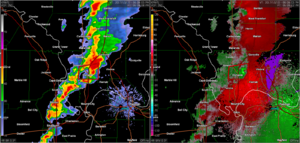
Why is NOAA not marking this as a tornado?

MikeD

EF1
Joined
Oct 10, 2017
Messages
86
Location
Miami
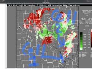
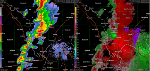
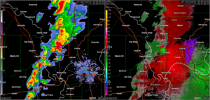
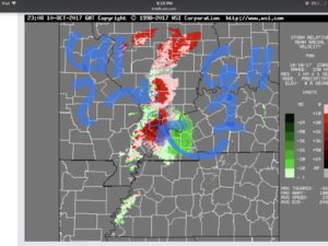
Last night, on October 10, I was looking at some radar sites near Kentucky. That was because a cell was issued a tornado warning and severe thunderstorm warning. A few minutes later, I noticed the cell above had taken on a kidney bean shape. I told myself, they’re not warning it, so it’s not a supercell. As the radar refreshed, the cell began to weaken and become the third image below. Even though it wasn’t as defined, I still took a screenshot and went to look at base velocity.

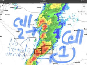
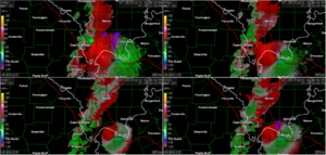
I first saw the rotation from the Kentucky radar. After that, I had to go to Missouri radar and verify rotation. I then took two screenshots. No tornado warning or severe t-storm warning was issued. This is what I’m asking: Am I wrong/seeing differently, or are meteorologists having tunnel vision on cell 1?

Sorry for the worst handwriting in the entire world.

Pic 1: Kentucky base velocity

Pic 2: Missouri base velocity

Pic 3: Base reflectivity
C91D7D7D-A935-4F08-8B2E-CAE4454E088A.jpeg 1D987069-F922-4CD6-8855-95E4C75D0ED3.jpeg CD99BBE4-029C-4CF0-8FED-9878B5B25FD1.jpeg
 
It's pretty difficult to confirm a tornado based on radar data alone, you need some other indication other than rotation. Rotation on a storm doesn't mean its gearing up to produce a tornado either, the rotation may only be in the mid levels with very little rotation being present at the low levels. As to why it wasn't even severe warned, it was likely not producing winds and hail that meet severe warning criteria.

The NWS doesn't just slap severe thunderstorm and tornado warnings on any storm that rotates, otherwise every single supercell would be getting warned.
 
Last edited:
The radar sites were too close to sense mid-level clouds.

As for the conditions, they would be right because the cell next to it was tornado warned.
 
Last edited:
What next cell? This storm was well north into the line - that's not typically a spot to find tornadoes.

If the conditions were right for a tornado - they likely would have issued a tornado warning and a tornado would have occurred :)
 
What next cell? This storm was well north into the line - that's not typically a spot to find tornadoes.

If the conditions were right for a tornado - they likely would have issued a tornado warning and a tornado would have occurred :)

Key word: likely

What do you mean by north of the line is not a typical spot?
 
I don't know what you mean by referring to "likely."

In a long line of storms, cells near breaks in the line and/or on the south end of the line are typical spots to look for tornadoes. This one was well behind the leading edge, embedded in stratiform rain, where tornadoes are not expected.
 
I did some research and discovered in a thunderstorm/squall/derecho line like this (especially bow echos), Quasi-Linear Convective System tornadoes DO NOT form in the south. They form up north.

Most powerful tornado type:

1. Supercell

2. QLCS (squall line tornadoes)

3. Land/water sprout

4. Gustnado/Fire whirl
 
Last edited:
Looks
Also, I found that in a bow echo, the northern end has the most chance of tornadoes.

What you're describing is a Bookend Vortex that is generally associated with Bow Echoes.

The line of storms in southern IL yesterday was not even remotely a Bow Echo. Looks to be a QLCS at best, if even that. Very unorganized looking.

As for the conditions, they would be right because the cell next to it was tornado warned.

Just because two storms are right next to eachother in a favorable environment for tornadoes does not mean both will produce. It's actually very likely that the south cell in this situation would interfere with the inflow of the north cell, as is likely the situation shown in your screencaps. The warned cell in the south has unimpeded inflow, while the second that you've circled has FFD precip falling into it's inflow region which greatly limits it's severe and tornadic potential. The term "Tail-end Charlie" is generally used to describe this situation by chasers.

Going back to the warning issue, I'd assume no storm reports that met severe criteria were submitted to the NWS as the storm was not warned, which is one major reason why it would not be warned. Outside of that, the NWS utilizes Dual-Pol radar data(ZDR)to get an idea of updraft strength to help them decide if they need to warn the storm or not when no spotters are on the storm. This is a great video to watch to learn how the NWS utilizes said data:

And a video on the warning decision making for the NWS:
 
I told myself, they’re not warning it, so it’s not a supercell.

While supercells commonly produce severe hail, wind, or tornadoes, not all supercells reach severe status. Also, in addition to looking at base velocity when analyzing a storm, look at storm relative velocity. Depending on the position and movement of a storm, base velocity doesn't always provide an accurate picture of what's going on in the storm.

The radar sites were too close to sense mid-level clouds.

NWS radars scan at multiple elevation angles so that forecasters can see what's going on in the different levels of the storm. Yes, this does depend on how near or far the storm is from the radar. Cell #2 in your image is somewhat in between several radars, so the lowest elevation scan (0.5 degrees) from any near by radar is probably sampling the mid levels of the storm given its distance from the radars.

In addition to the bookend vortex being a potential tornado producer in bow echoes, tornadoes can occur along the leading edge of the northern portion of the bow. However, I wouldn't classify the line of storms in these radar images a QLCS or bow echo.
 
Also, in addition to looking at base velocity when analyzing a storm, look at storm relative velocity.

To everybody: What is a good website/app/software/hardware to analyze storm relative velocity (Preferably free)? The only things I can find so far are base velocity websites and base velocity apps.

However, I wouldn't classify the line of storms in these radar images a QLCS or bow echo.

Of course not!
 
To everybody: What is a good website/app/software/hardware to analyze storm relative velocity (Preferably free)? The only things I can find so far are base velocity websites and base velocity apps.

The NWS EDD (http://preview.weather.gov/edd/) gives more stuff that most sites (including some dual pol), but not storm relative velocity. I've yet to find a free website that I like for radar. Investing in Radar Scope (mobile app $9.99) and/or GRLevel3 (windows $79.95) is well worth it. Either one of those would have made it much easier to tell why the NWS issued a tornado warning for one and not the other (which was the correct call). I downloaded this event and loaded it into GRLevel 3:

Here is the view just before the warning was issued. The area you called cell 1 to the south is tighter and the wind speeds are higher. The area you marked cell 2 to the north is not touching and the wind speeds are much lower. This is much easier to tell here than from the website you where looking at. Also note the classic hook to the southeast of Jonesboro.
1.png

Here is the next scan, and as you can see the warning has been issued. The TVS marker is covering up the hook somewhat:

2.png

Just for completeness, here is the next scan which is also the one you posted. The warned cell (#1) is not as impressive, and the cell to the north (#2) still isn't as impressive:

3.png

All of the above are the lowest level scan. You really need to look for vertical continuity between the scans too. In this case you can see the warned area is showing rotation across every scan displayed:

4.png

I should note that just because you see rotation at all levels, doesn't mean it is a tornado. Supercells all rotate and most don't produce tornados.
 
Back
Top