What is this "funnel" from the CO/WY/NE-outbreak?

Joined
Aug 27, 2009
Messages
197
Just before the "four state supercell" that produced tornadoes in three states before dying out in South Dakota it started off next to another supercell, west of it, near Ft Myers, CO. In the beginning, this western storm looked better than the ones that created all the tornadoes. This western supercell did however create a tornado north of Cheyenne.

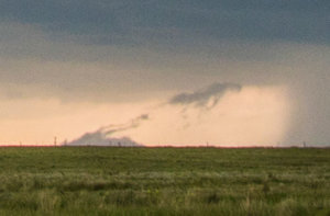
While we were heading down towards the other cell, we stopped briefly to take a few photos of the western cell. I took a photo in which a peculiar funnel like feature appears under the base. There were no tornadoes reported from it at the time. It could be a gustnado but it looks a bit too well shaped for it to be. I would have guessed tornado based on the shape if it wasn't for the weird angle as it is leaning heavily in towards the precis.

Did you see this as well? Do you have any idea what this might have been?
1807855523682a2f70b45fe92b28d1f8.jpg
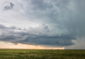
The storm as a whole.

729c795e97cd16d33d3c963ce1db9781.jpg
The zoom-in on the funnel-feature.
 
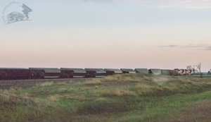
I will steal my own thread here to ask a different question of that same day. We bumped into a train and two semis that had been flipped by high winds. A tree was also torn apart. Does anyone know if this was caused by a tornado or by straight line winds?

8864839d1a4945814dd0bd173b9fae74.jpg
 
Just before the "four state supercell" that produced tornadoes in three states before dying out in South Dakota it started off next to another supercell, west of it, near Ft Myers, CO. In the beginning, this western storm looked better than the ones that created all the tornadoes. This western supercell did however create a tornado north of Cheyenne.

While we were heading down towards the other cell, we stopped briefly to take a few photos of the western cell. I took a photo in which a peculiar funnel like feature appears under the base. There were no tornadoes reported from it at the time. It could be a gustnado but it looks a bit too well shaped for it to be. I would have guessed tornado based on the shape if it wasn't for the weird angle as it is leaning heavily in towards the precis.

Did you see this as well? Do you have any idea what this might have been?

View attachment 16193
The storm as a whole.

View attachment 16194
The zoom-in on the funnel-feature.

This is a toughie. It would greatly help if I could see the "zoomed-in" version, but for whatever reason, I'm not able to bring it up. I will say this....that over the years I have seen a few "for sure-no guess" tornadoes that mimic exactly what you have shown, with a couple of exceptions: usually the tornadoes were bigger...not ropes, and in each case the tornado was framed by TWO extremely heavy rainshafts....very close to the tornado. If you can envision your picture with the addition of one more rain shaft placed exactly like the one to the right of the tornado but on the other side of it too....and that's what I've witnessed. Each time it's been on the Colorado high plains...and I have always kind of wondered if this "setup" is something more normal for the drier high plains. Some of these have lasted well up to a half-hour. One the other hand, I've also (and I'm sure many of you have as well) see what looks exactly like a tornadic vortex in instances of heavy-downpour induced-leading edge outflow winds that create a lengthy / ropy-scud look-alike funnel that begins at the ground and definitely gets lifted to storm base. With a little distance between yourself and this look-alike imposter, you and your chase partners will argue for miles as you drive along and try to ascertain what exactly it is that you're looking at. I've said for many many years that one of the biggest differences between a highly seasoned chaser and a rookie is the ability to see funnel-features in the sky and determine if indeed these are honest funnels/tornadoes or look-alikes. If I had to make a guess on your photo in front of a national t.v. audience with a million bucks on the line I'd have to say this is a slowly rising outflow-scud feature that looks like a rope tornado. These kind of photos are fun to figure out, imo! Keep 'em coming, guys.
 
Joel: Thanks for the elaborate answer. It's weird that you can't see the photo. I posted it in a tweet, maybe you can see it there: https://twitter.com/StormChasingUSA/status/884057167095103488 -

The clues of it NOT being a tornado are:
- no tornado was reported and there were numerous chasers on it as far as I remember,
- the bottom/ground part of it is too wide making it resemble more of a gustnado,
- there is no lowering at the base
- it is leaning towards the precip

All could still be true for a tornado though. The one reason it COULD be a tornado is that it has a very well defined shaft that looks a lot like a funnel! I could also imagine this being a landspout tornado.
---
Regarding the 2nd question, by the way, I don't expect anyone to understand that from the photo, it is merely if someone was there or remember this (which would be expected considering the amount of chasers on that storm).
 
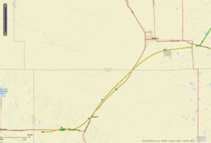
Oh, cool! Thanks! Was that any of the ones we saw? Did we hear about this while chasing (and I forgot) or did you do research when you got home? Is the yellow thing the tornado path? So many questions!

(Devin was in the same chase vehicle as I this day).
 
Ah, cool. Where did you get that image from? Have you seen if there were any videos of that one?
 
What a goldmine! It kind of answers my first question as well, as there were no tornado tracks where the first vortex (in my photo) was.

I don't remember what our conclusion about that vortex under the western cell was when we were there. I think I focused more on the storm structure at that point.

Maybe I should just note it down as a gustnado and move on with my life :)
 
Back
Top