Very good question.
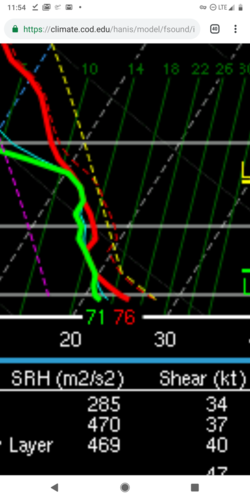
The surface based lifted parcel is calculated using the virtual temperature, which is a function of temperature and moisture. Because water vapor is less dense than air, the virtual temperature is always a couple of degrees warmer than the actual temperature for warm/humid conditions.
Depending on the user settings, Sharppy also displays the environmental virtual temperature as a dashed red line.
CAPE is the area between the virtual temperature and the parcel trace. You'll notice that as moisture decreases with height, virtual temperature approaches the actual temperature.
Importantly, this means that there is a little bit of CINH for the surface parcel below. If the virtual temperature line is removed from the sounding, it gives the misleading impression that the atmosphere is entirely uncapped.
View attachment 17787