Weaher Identification Needed

Joined
Sep 17, 2008
Messages
76
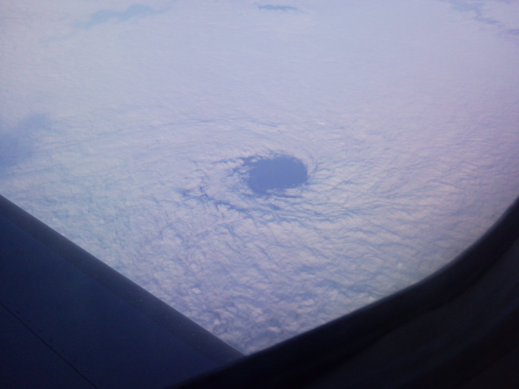
This photo was taken 20 min's off the coast of LA at around 7:30am. What am I looking at here? It looks like the eye of a hurricane.

3548058596_af539a5863_b.jpg
 
Here's the response I got from the NWS "It's a small scale eddy manifest in the stratus cloud deck. We see these all the time on our satellite images"

you learn something new everyday
 
It's Not a Hurricane!!

Please note the cloud circulation. It seems to be going clockwise. Normally a hurricane would be going counter-clockwise with high topped clouds. Like the anti-cyclones we see from time to time in our storm chase, this would be the tropical equivalent of a "anti-hurricane". :p
 
These small eddies or vortices are extremely common downwind of all the islands off the coast of Southern California and Baja during the spring and summer. Often times they will form long chains of alternating clockwise and counter-clockwise eddies called vortex streets (Von Karmen Vortices). On the best days, you can see as many as a dozen eddies lined up in a row. It's most common off Baja downwind of Guadalupe Island. In the case of the photo above, winds were pretty weak so instead of getting a chain of vortices, there was only one. Also, the direction of the wind may not have been ideal for multiple vortices as well.

On a side note... it seems that the visual appearance of the eddies depends on the thickness of the marine layer and the rate of vortex shedding. For example, the eddies may look more like a spiral galaxy when the general low level wind is stronger and the stratus deck is thinner. Conversely, the eddies may look more like the eye of a hurricane with the general low level wind is weaker and the stratus deck is thicker.
 
Also note that if it was a hurricane you would likely see some of the depth of the eye rather than just a flat looking deck of clouds. What is called the "stadium affect" is often if not always visible from the sky. Also remember about the high altitude you would have to be to see the top of a hurricane from this perspective, not likely in a commercial jet.
 
I did a little research on the Marine Atmospheric Boundary Layer last semester. I believe this may be an extreme case of what's called a Catalina Eddy.
 
I never tire of seeing good eddy photos. It's a nice reminder of how this island dynamic also fuels waterspouts and tornadic thunderstorms in Southern California. When the dynamics are right, seems all you have to do is position yourself leeward of the islands, or even the Palos Verdes peninsula with a camera and wait for the right opportunity to shoot.
 
Last edited by a moderator:
I never tire of seeing good eddy photos. It's a nice reminder of how this island dynamic also fuels waterspouts and tornadic thunderstorms in Southern California. When the dynamics are right, seems all you have to do is position yourself leeward of the islands, or even the Palos Verdes peninsula with a camera and wait for the right opportunity to shoot.

Too bad that special area didn't see much action this winter:mad:
 
Back
Top