Wall Cloud vs Outflow/Shelf

Joined
Jan 12, 2008
Messages
812
Location
Burlington, Kansas
First of all a disclaimer, I am self taught and have no official college training in meteorology so I can be wrong as I am no expert

I have had an issue nagging at me for a few years now here and in other forums with peoples identification of a wall cloud. I have seen so many shelf clouds identified as wall clouds that I myself am wondering if I am misidentifying a few. After yesterday I find myself nagged into this post. :)

From Wikipedia, the free encyclopedia:

Wall Cloud
A wall cloud, or pedestal cloud, is a cloud formation associated with thunderstorms. It is a marked lowering typically beneath the rain-free base (RFB) portion of a deep cumulus cloud (normally cumulonimbus but on occasion cumulus congestus), and indicates the area of primary and strongest updraft which condenses into cloud at altitudes lower than that of the ambient cloud base. Most strong tornadoes form within wall clouds.

Genesis
Wall clouds are caused by the ascending and converging inflow air of the updraft ingesting moist, rain cooled air from the normally downwind downdraft. In supercells this is the forward flank downdraft {FFD}. Since temperature tends to be reduced and dew point (moisture content) increased, as the updraft entrains this air, saturation occurs sooner as the air rises. Wall clouds may form as a descending of the cloud base or may form as rising scud consolidates and organizes.


Arcus cloud, aka shelf cloud:
An arcus cloud is a low, horizontal cloud formation associated with the leading edge of thunderstorm outflow, or occasionally with a cold front even in the absence of thunderstorms. Roll clouds and shelf clouds are the two types of arcus clouds, slight variations in their generation and look being the difference.

Formation:
Cool, sinking air from a storm cloud's downdraft spreads out across the surface with the leading edge called a gust front. This outflow undercuts warm air being drawn into the storm's updraft. As the cool air lifts the warm moist air, water condenses creating a cloud which often rolls with the different winds above and below

Roll cloud
A roll cloud is a low, horizontal, tube-shaped, and relatively rare type of arcus cloud. They differ from shelf clouds by being completely detached from the thunderstorm base or other cloud features. Roll clouds usually appear to be "rolling" about a horizontal axis. They can be a sign of possible microburst activity.

Shelf cloud
A shelf cloud is a low, horizontal wedge-shaped arcus cloud. Unlike a roll cloud, a shelf cloud is attached to the base of the parent cloud (usually a thunderstorm). Rising cloud motion often can be seen in the leading (outer) part of the shelf cloud, while the underside often appears turbulent and wind-torn.

Occasionally people seeing a shelf cloud may believe they have seen a wall cloud. This is a common mistake, since an approaching shelf cloud appears to form a wall made of cloud. Generally speaking, a shelf cloud appears on the leading edge of a storm, and a wall cloud will usually be at the rear of the storm.

Wall cloud vs. shelf cloud
Occasionally people see a shelf cloud and think they have seen a wall cloud, which is an easy mistake, since an approaching shelf cloud appears to form a wall made of cloud. Generally, a shelf cloud appears on the leading edge of a storm, and a wall cloud will usually be at the rear of the storm, though small rotating wall clouds associated with mesovortices can occur within the leading edge on rare occasion. Wall clouds will tend to slope in, or toward the precipitation area, whereas shelf clouds as outflow clouds will jut outward from the storm. Wall clouds are inflow features with (often warm) air moving towards them whereas as shelf clouds are an outflow feature with cool air moving away from the storm, often as a gust front.

A shelf to me: (I have seen this called a wall many times)
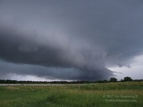


The only time I really questioned a shelf was the one posted above that had a rotational area in the middle (picture above is right of this area) where the cell started rebuilding a stronger cell ahead of the original cell that created the shelf and may have indeed been a wall forming by coincidence in the middle of the existing shelf. You can see the hail core in and behind it. I shot this East of the storm it was a right mover heading at me.
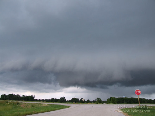

This was the original cell West of and 20 minutes earlier than the pics above.
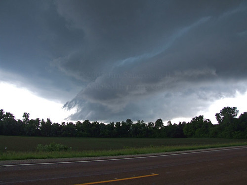

I would like to see some discussion with photos and examples. ( I had more but were lost in my HD crash)
 
A shelf to me: (I have seen this called a wall many times)


The only time I really questioned a shelf was the one posted above that had a rotational area in the middle (picture above is right of this area) where the cell started rebuilding a stronger cell ahead of the original cell that created the shelf and may have indeed been a wall forming by coincidence in the middle of the existing shelf. You can see the hail core in and behind it. I shot this East of the storm it was a right mover heading at me.

Above and to the right of that utility pole is wall cloud. The 'shelfy' portion on the left is the rear flank gust front, which is RFD air rushing outward and wrapping around the meso. You can see a couple inflow tails to the right of the wall cloud which is another indicator that it is not outflow dominant like a shelf.

From http://ww2010.atmos.uiuc.edu/(Gh)/guides/mtr/svr/torn/dgr/evsch.rxml:
evsch1.gif
 
Good question.

I'll let others with more experience answer, but I'll just put in my 2 cents. Wikipedia is a nice way to get a basic intro to a subject, or links to more definitive sources - but I wouldn't use them as my primary source.

The glossary page for storm spotters (Norman) gives this definition for wall cloud:

*Wall Cloud - A localized, persistent, often abrupt lowering from a rain-free base. Wall clouds can range from a fraction of a mile up to nearly five miles in diameter, and normally are found on the south or southwest (inflow) side of the thunderstorm. When seen from within several miles, many wall clouds exhibit rapid upward motion and cyclonic rotation. However, not all wall clouds rotate. Rotating wall clouds usually develop before strong or violent tornadoes, by anywhere from a few minutes up to nearly an hour. Wall clouds should be monitored visually for signs of persistent, sustained rotation and/or rapid vertical motion.

So, I'd think that most anything on the leading edge of a big storm is rarely going to be properly called a wall cloud.
 
Jim,

When a clear slot forms in a wall cloud, the rear flanking downdraft is in the process of punching through. It often continues to do so until the original wall cloud has fanned out into what looks like a regular shelf cloud. This is what happens when an updraft becomes occluded. At this point I would say the feature actually is a shelf cloud as the RFD is dominant. Your typical shelf clouds are usually formed by forward flanking downdrafts in multicell clusters and squall lines.

In a cyclical supercell, the north end of that bowed out wall cloud is going to reorganize, tighten into a new wall cloud, and the whole process repeats. Your strongest tornadoes form here, while the old wall cloud fans out well to the south. May 5, 2007 was a prime example of this. We had what looked like a completely occluded base, and so were in the process of bailing, but the north end reorganized and we had a cone tornado minutes later:

Looking southwest at a lowering exhibiting classic shelf structure: Curtain like appearance, pointing away from the precip core:
07050512.jpg


Looking northwest, we have wall cloud structure including a big inflow tail feeding in from the precip core:
07050514.jpg


Looking north after this structure passes overhead:
07050515.jpg


So to sum it up, I would say your wall cloud bows out into a shelf cloud when the RFD becomes dominant. However, the north end can recycle into a wall cloud, or remain a wall cloud. When chasers refer to a big bowed out curtain as a wall cloud they are probably talking more specifically to an area of rotation within the lowering, or organization at the north end, as the whole thing was probably a more classic wall cloud minutes earlier. Keep in mind that the middle portion of that bowing wall can drop tubes as they may contain weaker vortices.
 
Above and to the right of that utility pole is wall cloud. The 'shelfy' portion on the left is the rear flank gust front, which is RFD air rushing outward and wrapping around the meso. You can see a couple inflow tails to the right of the wall cloud which is another indicator that it is not outflow dominant like a shelf.
[/IMG]

Now I am confused, lol.

You grabbed the text describing the middle picture but posted the first. The one you reposted was the NE section of the storm (the NE leading edge) which puts it at the wrong end of the normal area for a wall cloud.

Good question. Wikipedia is a nice way to get a basic intro to a subject, or links to more definitive sources - but I wouldn't use them as my primary source.

It was just the quickest grab for me. :)

So, I'd think that most anything on the leading edge of a big storm is rarely going to be properly called a wall cloud.

That's my problem with the pictures above, I am on the East "leading edge"

The cell was June 01, 2007 East of Neodesha KS about 6:53 PM. (I lost the link to the radar archives for grlvl3 so cannot grab a shot) Link anyone?

This is a gif of the rotational area

After it passed looking East:
 
Last edited by a moderator:
Being one of only a few persons that reported a wall cloud yesterday I feel the need to explain my call. First of all I do agree with you that there are more than enough faulty reports such as SLCs as funnels or shelf clouds as wall clouds. I actually witnessed a local news person nearly fear mongering at a gas station in Sedan, telling the employees and doing a phoner explaining how he witnessed multiple funnels headed towards town. Observing the storm myself it was clear that this reporter either needed more experience or more than likely enjoys drama! My call was simple. The line of storms were still inflow dominant at the time. That in itself makes a shelf cloud impossible. There was a notch in the line (inflow) and a lowering which showed some very weak rotation. Those things seemed to gel with what I was seeing on radar. Not to mention the fact that the storm was tornado warned. I do not have a great deal of formal training but I do have 13 years of storm chasing experience. Not sure if you were referring to me but wanted to defend myself just in case.
 
Not sure if you were referring to me but wanted to defend myself just in case.

I am not referring to any one person at all, it is not my wish to do so.

There are apparently some questions in others minds however about some of the wall cloud reports yesterday. Did you get any photos by chance of what you seen and reported that can be used in the discussion? I only seen a little of the video from that area as it seemed to be an area of poor reception but never seen anything relevant one way or the other.

There were other reports besides the ones made to SN
 
There were a few legit wall clouds associated with yesterdays activity (though none displayed rotation of any significance), it was deceiving many times, as cell mergers and downdrafts raining on the neighboring storms updraft was a major issue in recognizing storm structure. I think often folks confuse the leading edge and rain-foot area with a wall cloud, especially in non-classic supercell storms. In my personal opinion the definition of the term does not hold up to the power the term "wall cloud" carries. IMO far to many things are called wall clouds now days that IMO should not be. I use the same strict method for claiming something a wall cloud as I do for calling something a funnel or claiming strong rotation in a storm, if you have to question it at all, then it is likely not, you know for sure when you see one.
 
Last edited by a moderator:
There were a few legit wall clouds associated with yesterdays activity (though none displayed rotation of any significance), it was deceiving many times, as cell mergers and downdrafts raining on the neighboring storms updraft was a major issue in recognizing storm structure. I think often folks confuse the leading edge and rain-foot area with a wall cloud, especially in non-classic supercell storms. In my personal opinion the definition of the term does not hold up to the power the term "wall cloud" carries. IMO far to many things are called wall clouds now days that IMO should not be. I use the same strict method for claiming something a wall cloud as I do for calling something a funnel or claiming strong rotation in a storm, if you have to question it at all, then it is likely not, you know for sure when you see one.

I have seen many people call things funnels that I would never call a funnel because it wasn't what I considered to be a funnel nor did it fit the common definition of a funnel.

I do believe that I have ignored a few possibilities because though it fit the definition it was not the classic look.
 
As I always say, mother nature sometimes doesn't fit into a neat little box of our scientific definitions. There are always exceptions and moments of "what the heck is THAT?". Even Al Moller, a 30+ year chase veteren himself, has said that every year he chases to this day, he still sees things that makes him utter that same question. As a result, sometimes the best definitions are "hybrids". Trying to force something into a specific and well-defined classic definition just doesn't work sometimes, and that's ok. :-)

I have seen definite shelf clouds move southward out of a storm then become stationary. Another updraft then develops and transitions the shelf cloud into a wall cloud. In reality, a new storm developed along the outflow boundary from the other storm ahead of it...classic. You can even see this on radar sometimes.

I remember a great SKYWARN slide that Gary Woodall of the NWS Fort Worth had. It showed a pretty stout shelf cloud, but with notable convective properties (strong cumulus growth). Another picture a little further north showed a nice tornado that developed in a kink or slight notch in the shelf cloud.

Last year near Pratt, KS, David Drummond and I observed a weak multi vortex tornado which developed in a similar manner along a big shelf cloud with no real apparent wall cloud associated with it.

I have seen scud bombs race outward from the precip area, stop, ascend into the new updraft region and grow as it transforms into a wall cloud.

So, I don't know if my comment helped or not....just thowing my $0.02 out there. ;) I'm just saying that the answer to your question may not be clear-cut.
 
I've found that a relatively reasonable rule of thumb is:

If the feature tilts down towards the precip, it's more likely to be a wall cloud than a shelf cloud.
If it tilts away from the precip, it's indicating outflow, and is more likely to be a shelf cloud.

However, you should be careful where the RFD is concerned as the portion close to the updraught can go very quickly from being an area of outflow to an area of inflow.
 
Jim, I saw something similar to that this year on June 4th, except there was rain and hail behind the feature.

There was a shelf cloud extending all along the storm, but at the one end, it showed signs of inflow, forming a long inflow band and the base was lower than the rest of the shelf cloud. Could this be one of those wall cloud exceptions?

20080604_Supercell1.jpg
20080604_Supercell2.jpg
 
Jim, I saw something similar to that this year on June 4th, except there was rain and hail behind the feature.

There was a shelf cloud extending all along the storm, but at the one end, it showed signs of inflow, forming a long inflow band and the base was lower than the rest of the shelf cloud. Could this be one of those wall cloud exceptions?

I don't know. :( (somehow I missed your reply till now)

I did find this short clip from me testing the video feature in that camera at that time though.

Can anyone post the link to the archived grlvl3 /2a radars again?
 
I've found that a relatively reasonable rule of thumb is:

If the feature tilts down towards the precip, it's more likely to be a wall cloud than a shelf cloud.
If it tilts away from the precip, it's indicating outflow, and is more likely to be a shelf cloud.

However, you should be careful where the RFD is concerned as the portion close to the updraught can go very quickly from being an area of outflow to an area of inflow.

I agree with all this, but I have also witnessed tornadoes (besides gustnadoes) along shelf clouds as well. Matt and I witnessed a brief tornado that formed along a shelf cloud in Barber County, KS on May 6th, 2007 just southwest of Medicine Lodge. The area of interest along the shelf cloud was a little inflow cut into the shelf cloud. This tornado had full condensation on the ground, it was not a gustnado. I am sure Matt got better and longer video of this tornado than I did. I called in a report of the tornado and missed filming most of its short lifecycle.
 
First, my reply to Laura's post about the June 4th example. That horizontal band of clouds coming in from the right is definitely inflow. It looks like a sort of beaver tail.

Matt H. mentioned that if he saw inflow to a storm then it was not possible to have a shelf cloud. I don't necessarily agree with that. Shelf clouds that lead squall lines do have inflow. It's just not inflow from right under the shelf. Rather it's inflow riding up over the cold pool that's racing out ahead of the storm. The air flow pattern in those kinds of squall lines rides up into the shelf and then into the updraft and out ahead of the storm through the anvil. In fact, when you get under the shelf you can usually see rising motion on the underside of it...I refer readers to Mike Hollingshead's site and the May 29th 2008 account: http://www.extremeinstability.com/08-5-29.htm. A few of the photos show clear rising motion just by the shape of the belly of the shelf.

My take on the genesis of wall clouds is that they form due to the localized area of low pressure under the mesocyclone. Since the pressure is lower there, air parcels flowing into this region experience more expansion and cooling (1st Law of Thermo), and condense at lower levels than parcels that do not flow through the lower pressure under the meso. Granted, this is assuming all parcels are rising from the same level and in a uniform environment, but I think the spatial scale of mesocyclones makes assuming that okay.

This is also my take on why condensation funnels form...however, my "theory" doesn't explain why some (even strong) tornadoes do not have a condensation funnel all the way to the ground.

Would anyone else like to comment on this? I doubt I'm entirely right.
 
Back
Top