Tropical Cyclone to Affect Florida Next Week?

Joined
Feb 19, 2021
Messages
649
Location
Wichita
The ICON (18Z and 00Z), GFS (12 and 18Z), SPIRE (12Z) and UKMET (12Z) have a tropical cyclone striking Florida next week.

But, for me, the #1 reason it is most likely to happen is that the GFS doesn't forecast it. I'm only slightly kidding.

The 00Z ICON is at left. The 00Z GFS at right.

P.S. I'm not sure why there is a double image below. I've tried to fix but it is still there.

BTW, the 00Z Canadian looks almost exactly like the ICON.
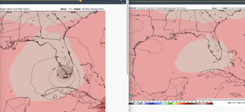


Screen Shot 2023-08-23 at 11.06.57 PM.pngScreen Shot 2023-08-23 at 11.06.57 PM.png
 
Last edited:
Keeping a watch on this. NHC seems relatively confident in forecasting some type of tropical event. Gulf is primed and ready to go, so any storm would be a serious threat in a short amount of time. Models should have a much better handle on it by late tomorrow.
 
It will be interesting to watch for sure. SST's, minus whatever shear effects there may be down the line, are certainly primed for a rapid intensification. land interactions may be another factor to initially.
 
Now a depression & not that far from being a TS. Forecast to become a TS tomorrow & Hurricane by tues.
Think the big question is going to be just how rapidly this thing intensifies over that warm water in the gulf

I'll be keeping an eye on the NHC website to see what happens with this one.

Looking at the current forecast track of it crossing FL & heading up the east coast as a TS. Could be a bad one depending on how strong it gets. :eek:
 
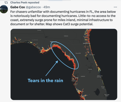
Going to take a BIG chance and pass on this one. Been sitting on the fence, putting a lot of uneasy faith in the models to keep the track north into the wetlands of the Big Bend where little or no infrastructure makes for few survivable chasing opportunities. Not willing to gamble the $2,500+ it would cost to get there and chase. The intensification will be very interesting to watch. I would not be surprised to see it go H4.

Also fun to watch the media and chaser sorcering as they try so hard to pull the storm south towards Tampa. People are picking the models of choice with the furthest S/E track. Having said this, it's still quite possible it could turn east w/o notice.


I was literally watching that this morning from local stations in and around the Tampa area. Amazing to see that happen. I mean, I "assume' the purpose is to get upticks in viewership as a potential a "call to actions" even if they are playing that model game as you mentioned. Gray area ethics but probably for the good in some ways.

as to the 4, I'd agree, there's a real chance for it since the upper levels appear to have some favorable conditions over the next 36hrs to get it to CAT3 as it is.
 
Going to take a BIG chance and pass on this one. Been sitting on the fence, putting a lot of uneasy faith in the models to keep the track north into the wetlands of the Big Bend where little or no infrastructure makes for few survivable chasing opportunities. Not willing to gamble the $2,500+ it would cost to get there and chase. The intensification will be very interesting to watch. I would not be surprised to see it go H4.

My chase partner and I came up with a name for this - “Reverse Chasing” - when you decide for whatever reason not to chase an event, then keep an eye on things and root for something not to happen so that your decision will turn out to be the right one. Sounds like this can apply to hurricane chasing as well as supercell and tornado chasing.

Good luck on your Reverse Chase, Warren! 😜
 
Here's my FB rant:
Ok, here is my rant on the media coverage of Idalia. As I mentioned in my earlier post today, the storm surge was well predicted and people near the coast definitely needed to be inland and higher up for this storm. But as I also mentioned earlier, Idalia was a fairly small hurricane and it is not uncommon for storms like this to weaken rapidly just before or upon landfall. Which is why I was quite skeptical of it reaching Cat 4 status at landfall--although it did undergo rapid intensification overnight and I thought it "possibly" could reach Cat 4 status at landfall. NOAA is claiming it briefly reached Cat 4 status offshore, but this was clearly based on flight level winds and I suspect it was not Cat 4 strength 10m above the surface. Now I look at the post landfall media reports and they almost universally quote the 'official' intensity at Cat 3, and sustained winds of 125 mph. I have no idea where the 125 mph winds were recorded at this point in time, but it seems to me someone just took an 'official' forecast advisory which presumably listed "125 mph winds" and that has what made the headlines. However, based on live video I watched of landfall along with damage photos, I strongly doubt that winds got much above 100 mph even in the worst hit areas. I'll correct myself if needed, but I saw nothing to indicate winds over 80ph let alone 100 mph. A look at official ground (10m) records show *sustained* winds of around 60-65mph with *gusts* to 80-85mph--even near the inner eyewall, where winds should have been the strongest. So I seriously doubt that idalia was more than *Cat 2* --at least at landfall! But what's done is done, and I guarantee that there will be no downgrade at this point, even if no one can come up with evidence that winds were Cat 3 at landfall. Too many headlines and official statements are on the record and too many insurance claims will be based on them. Those on the ground--at least those who know how to measure or estimate winds--will know that winds never got that strong. And that just serves to increase distrust of the media and distrust of the warning agencies. I understand the reasons *why* the officials will air on the side of stronger or more destructive sounding forecasts--one reason is the public is generally unfamiliar with how much damage the wind can do, even at lower speeds. And they are also prone to ignore warnings to begin with, so strongly worded messaging is often needed. But I wish the official sources (like my old boss, NOAA) would do a better job of communicating *factual* information about the storms, cause without that you get a flood of factually incorrect headlines about the storm. I can almost guarantee that even months from now, Idalia will go down in history as a Cat 3 storm at landfall, which until someone shows me otherwise, is *factually* incorrect. END OF RANT
🙂
 
I am not so sure it won't be adjusted downward. They have adjusted upward or downward in the past. I could find no measured gust stronger than 86 mph, and no hurricane-force sustained wind reports. Now I know, the measurement sites are sparse, but I doubt there were actual gusts 30 mph stronger than anything measured, and certainly not sustained wind of 125 mph. Cat 2 sounds about right to me. There seems to have been an eyewall replacement cycle near landfall, so signifcant weakening likely ocurred from whatever the peak strength really was.
 
Back
Top