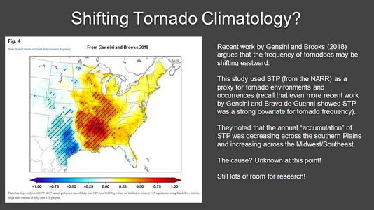
Agreed - for many years I spent almost no time chasing in that area, which is a real shame given that the region west of Lubbock has the best terrain and road network anywhere. But I do feel like the last three years have included much more activity out that way, and further into southwest Texas near Midland and into New Mexico. That could just be anecdotal, and even if real may not signal any actual shift “back”.
.
One item though, and this is a constant that does not change regardless of the climate, the Plains are the location that is the most favorable for severe thunderstorms and tornadoes in the world b/c of the geography of the area.
First, when you have a high N-S mountain range present with mean westerly flow aloft and flat, rolling plains to the E, you are going to have lee-side troughing, which promotes SE and E low-level winds often below that mean westerly wind flow aloft. This sets up excellent directional shear on many days, even when no strong synoptic forcing is evident (20 kt from the NW at 500 mb, and 20 kt from the SE at the sfc, voila!, 40 kt 0-6 km shear with 180 deg turning)!
Second, the subsidence off the Rockies promotes an EML much of the time, which leads to steep mid-level lapse rates and a capping inversion. The capping inversion allow sfc-based CAPE to build, with often explosive convective development when the inversion is overcome.
As you head farther E to the MS Valley, you lose that lee troughing/directional shear advantage, and the EML starts wane b/c farther W convection overturns the pristine EML and you are geting into a lower elevation, much more humid climate.
Addiaitonaly, the S low-level jet that ramps up around sundown over the Plains due to the uneven cooling of the sloped elevation higher as you go from E to W, which can and does fire tornadic storms very late when storms struggle to form or sustain during the diurnal max. You don't have this feature nearly as prominent outside the Plains. An excellent example of this was the Greensburg event. Find a case in the SEUS or MS Valley where a single supercell produced multiple strong/violent tornadoes and so many (22) after sunset. In fact, all single supercell events that have produced 20 or more tornadoes have been in the Plains.