Tornado Magnets?

I think geography plays much more of a factor than we realize. I remember as a kid that my region in the TX Panhandle (Moore, Sherman, and Hansford) saw far less action than Armstrong, Castro, and Swisher. I need to do some statistics to see if my memory aligns with real data.

Getting more specific to your question, there was always a legend about how the oil refinery southwest of our town (Sunray) was safe from tornadoes due to the amount of heat generated there. Sure, it never got hit, but I don't think anyone could prove it was for that reason.

I am no authority on the topic, just offering a viewpoint. I hope someone can school me on this and explain my cloudy thinking away.

Interesting topic...

Sent from my LG-H910 using Stormtrack mobile app
 
On a larger scale, yes geography plays a factor. Air masses affect different areas of the United States differently. Time of year matters too. You can see this in the tornado climatology maps. There are some documented localized areas as well, such as the Denver Convergence Vorticity Zone (DCVZ) https://en.wikipedia.org/wiki/Denver_Convergence_Vorticity_Zone.

But this article...
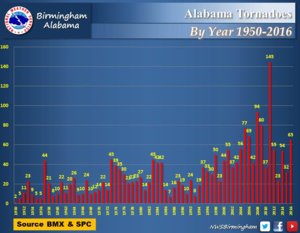
Yes, 49 tornadoes over 10 years seems like a lot. But it also says there were 40 tornadoes on Wednesday, and 0 touched down on Sand Mountain. So it appears to me (just based upon the article only), that there are a lot of tornadoes in Alabama. Sand Mountain happens to be in Alabama. 49 tornadoes in Sand Mountain over 10 years. In the last 10 years, Alabama got hit by 627 tornadoes (if I'm doing my math right). So Sand Mountain gets 7.8% of the tornadoes in Alabama. Sand Mountain looks like it covers about 7.8% of the state (https://en.wikipedia.org/wiki/Sand_Mountain_(Alabama)).

In conclusion... is it a "magnet"? No. Not to me. It looks like 7.8% of Alabama gets 7.8% of the tornadoes.


811916ca965aaea97e5e7a9f5d9d9288.jpg
 
Scott, what you say here.

On a larger scale, yes geography plays a factor. Air masses affect different areas of the United States differently. Time of year matters too. You can see this in the tornado climatology maps. There are some documented localized areas as well, such as the Denver Convergence Vorticity Zone (DCVZ) https://en.wikipedia.org/wiki/Denver_Convergence_Vorticity_Zone.
View attachment 15487

Begs the questions, do any models. Take into account of Vorticity Zones? I mean since there landmarks, so to speak. They don't move around. Shouldn't they be in or include with weather modeling systems?..
 
Marshall County (right there in the Sand Mountain area) had 15 different tornadoes occur in a single day (4/27/11). I have no idea what, if any, effect topography had on these tornadoes, but that's astonishing nonetheless.
 
Begs the questions, do any models. Take into account of Vorticity Zones? I mean since there landmarks, so to speak. They don't move around. Shouldn't they be in or include with weather modeling systems?..

Yes. All NWP models, including those run operationally and those run experimentally, include very high resolution terrain information as a state variable. The WRF, for example, allows for terrain resolution of up to 30-arcsecond (well under 1000 meters). All terrain effects that will impact anything on the scale of what the atmospheric grid can resolve are represented.
 
Interesting article. I think it will be informative to see what the results of the current research will be, as it sounds like they are getting some interesting data. I recall reading somewhere a year or two ago about research somewhere in the Southeast (not sure if it was Sand Mountain or somewhere else) showing that tornadoes were more likely to occur when a meso moved over a high area and reached the eastern edge of that area where the terrain drops off - perhaps due to some kind of stretching process? I observed a similar process in the September 29, 2014 tornado west of Chama, NM in which a supercell which had been producing severe hail and at times wind for about 30 miles produced a tornado as it moved off the eastern edge of a mesa in an area where, according to the NWS damage survey, the elevation ranged from 7500 to 9800 feet. (Coincidentally, that is the tornado you see in the picture in my member identifier at the left, FYI).
 
I think once there done studying Sand Mountain area. They should study the town of Wedgefield, FLA. Has had 177 Tornadoes since 1950 to present. Averages about 3 tornadoes a year. In 1972 they had 10 tornadoes in one year. Has a population of 6700. Small area for so many tornadoes. Good place for chasers to retire? Warm all year round. Go to the beach. Cape Canaveral base near by and Tornadoes come to you...

Side Note: What a name, "Wedgefield".
 
Here in the UK there *appears* to be an area of enhanced tornado occurrence to the east/north-east of the Isle of Wight, along the south coast. It's a tricky stat to unpick, as the coastline is fairly densely populated along there, but even so, it's generated much interest. The island is quite hilly, and so one would expect that Von Karman vortices would be shed downwind of the island. In unstable south-westerly flows, it's feasible, at least, for a vorticity zone to be present to the north-east of the island, such that any passing active convection could stretch this, perhaps into a non-mesocyclone tornado. I remain to be fully convinced, but I think complex terrain can produce all manner of vorticity banners, etc, which passing storms could take advantage of.
 
Here in the UK there *appears* to be an area of enhanced tornado occurrence to the east/north-east of the Isle of Wight, along the south coast. It's a tricky stat to unpick, as the coastline is fairly densely populated along there, but even so, it's generated much interest. The island is quite hilly, and so one would expect that Von Karman vortices would be shed downwind of the island. In unstable south-westerly flows, it's feasible, at least, for a vorticity zone to be present to the north-east of the island, such that any passing active convection could stretch this, perhaps into a non-mesocyclone tornado. I remain to be fully convinced, but I think complex terrain can produce all manner of vorticity banners, etc, which passing storms could take advantage of.

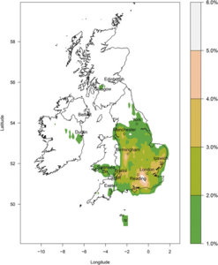
Here's a tornado climatology map of the UK. You'll have to point out where the Isle of Wight is on this map for me.

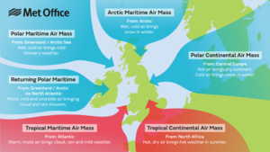
Other than the United States, the UK has always interested me because they get more tornadoes per area per year than any other country in the world, leading some to call the UK the tornado capital of the world. London is definitely a hot spot / magnet, or whatever you want to call it. But I think this has more to do with air masses than geography, given that much like in the US, tornadoes occur where tropical and polar air masses collide (see Met Office map).

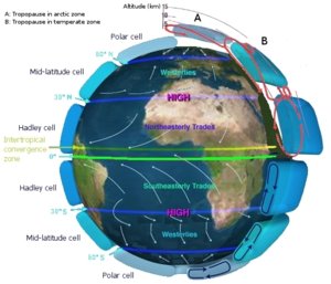
I've also heard that due to the UK's location on the globe, atmospheric circulation occurs above the UK (see third image). As you pointed out, the atmospheric circulation is caused from a SW polar flow and NE tropical flow meeting. I don't know if "vorticity zone" is the correct terminology, but atmospheric circulation is well documented.

I've also heard that the jet stream, which greatly affects UK weather, causes low pressure systems to develop. But it appears, based upon the maps I can find, that the colliding air masses cause UK tornadoes more than any other factors, since atmospheric circulation and the jet stream affect all of the UK.

Note: The UK (much like Turkey when I lived there) has skewed data due to population density. Tornadoes are more likely to be reported in densely populated areas than sparsely populated areas.

e0181aa981b65507a29de47efece9f7d.jpg
0bd5bf47ded0dbc364d3266ab5d7451c.png

513790b3f39f1fadda778d38424ca9f6.jpg
 
The Isle of Wight is the small island off the south coast, about halfway along. You can see that, even on that map, there is a region there of high numbers. There is also likely to be population bias across SE England, as the density is very high (England is about the same area as OK without the Panhandle, but with ~55 million people!).

Many of our tornadoes (probably over 50%) are non-mesocyclone in nature, e.g. they are from either single-cell 'pulse' storms, or from lines on cold fronts, or surface troughs, etc.

Although fronts are a source of lift, and fronts form along the edges of airmasses, it's best to refrain from citing a 'clashing of airmasses' as a cause of tornadoes. The Met Office map isn't a good guide to why tornadoes form in the UK, IMO.
 
Marshall County (right there in the Sand Mountain area) had 15 different tornadoes occur in a single day (4/27/11). I have no idea what, if any, effect topography had on these tornadoes, but that's astonishing nonetheless.

I'd want to know how those 15 "different tornadoes" were counted. Who knows....the person counting them might have been an inexperienced citizen "spotter" who simply counted several different suction vortices from a multi-vortex tornado.
 
I'd want to know how those 15 "different tornadoes" were counted. Who knows....the person counting them might have been an inexperienced citizen "spotter" who simply counted several different suction vortices from a multi-vortex tornado.

They were surveyed by the NWS. I consider them "experienced" :) (But I don't count 15.)
 
I think once there done studying Sand Mountain area. They should study the town of Wedgefield, FLA. Has had 177 Tornadoes since 1950 to present. Averages about 3 tornadoes a year. In 1972 they had 10 tornadoes in one year. Has a population of 6700. Small area for so many tornadoes. Good place for chasers to retire? Warm all year round. Go to the beach. Cape Canaveral base near by and Tornadoes come to you...

This one I do question though :) According to NCDC, the entire county (Orange) has seen 63 tornados in the last 67 years, for an average of less than one per year for the whole county. How did that city get three times as many as the county?
 
I don't think there's such a thing as a tornado magnet in the traditional sense of the word. However, I do believe that terrain can highly influence an existing storm's behavior, and in some cases, help initiate new storms in a preferential location. However, with topographical features as small as these mountains are, I doubt they have that noticeable an influence on forcing new convection. I think the best thing orographic gradients like that can do is supply any extra little kick of horizontal vorticity and help a passing updraft tilt it into the vertical. So perhaps the mountain increases the probability of a given storm producing a tornado, but that assumes all other ingredients are already in place, including the storm itself. The overall impact is probably not enough to overcome other statistical processes, though.
 
Back
Top