Jason_Dasho
EF0
I'm currently working on my chase logs from last year. I am in the process of reviewing a local storm I chased east of Pauls Valley on July 30th. I have a few question pertaining to tornado development in relation to squall line events.


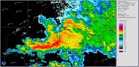
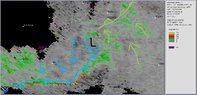
While chasing the storm I played the coma head region in hopes of getting a quick spin up

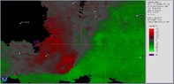
The image below with the circle shows the area of high turbulence using the spectrum width that I had targeted. My drawing on the image our my thoughts of what is going on here. In essence the squall line formed a mini triple point.
.

The area I targeted had a brief area of rotation (intentionally not calling it a funnel cloud), but quickly became broad and dissipated. LCL were extremely low as it was almost scraping the ground near area in question. So after a long intro my questions are: 1. Is my thoughts that this is a triple point on a micro scale correct? 2. What conditions would have been needed to help tighten this up for tornado formation? Is it a surge in the inflow notch producing the bow? Would it be an increase of winds into the warm inflow into the storm? Or something else?
While chasing the storm I played the coma head region in hopes of getting a quick spin up
The image below with the circle shows the area of high turbulence using the spectrum width that I had targeted. My drawing on the image our my thoughts of what is going on here. In essence the squall line formed a mini triple point.
.
The area I targeted had a brief area of rotation (intentionally not calling it a funnel cloud), but quickly became broad and dissipated. LCL were extremely low as it was almost scraping the ground near area in question. So after a long intro my questions are: 1. Is my thoughts that this is a triple point on a micro scale correct? 2. What conditions would have been needed to help tighten this up for tornado formation? Is it a surge in the inflow notch producing the bow? Would it be an increase of winds into the warm inflow into the storm? Or something else?