• While Stormtrack has discontinued its hosting of SpotterNetwork support on the forums, keep in mind that support for SpotterNetwork issues is available by emailing [email protected].

The "Violent Tornado Alley" of the southern Midwest

Joined
Jan 14, 2011
Messages
3,516
Location
St. Louis
I just posted this blog with an updated version of a map I made for the Tri-State Tornado 90th anniversary, showing the remarkable cluster of near-parallel F4 and F5 tornado tracks in a small 30-mile corridor in Missouri and Illinois. Last week's EF4 is the latest one to fall into this area.

http://stormhighway.com/blog2017/march917a.php
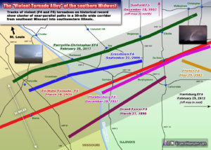
tormap2017.jpg

Also - if you plot all F3 tornadoes on http://www.tornadohistoryproject.com, there is a large cluster of F3s in nearly the same place!
 
Last edited:
Looking at this area on Google maps, the topography of this area has some similarities to the Caprock area of the Texas Panhandle. Many of us can attest to Caprock magic, and I can't help but wonder if topography is playing a role in both of these places.
 
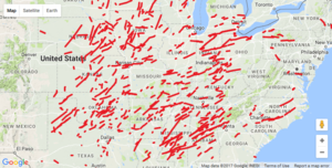
Map of all F4s from the tornadohistoryproject web site:
F4.png

I don't see anything remarkable about S IL/SE MO/W KY. Looks like statistical noise to me. If you're going back some 125 years you're bound to find a handful to tornado tracks running across any strip of land between I-25/I-75 and I-20/I-94. That's just sampling the tornado alley of the US. Parallel tracks also are not meaningful, as most tornadic storms move from southwest to northeast as they're forced by synoptic scale cyclones which feature southwesterly flow throughout most levels above the surface.
 
I wouldn't say *anywhere*- I went back and pulled historical data for all of southern Illinois, and there are several such isolated clusters of activity (the Perryville-Carbondale-Griffin is by no means the only one) separated by very large gaps. Even the map you referenced above illustrates that. Whether or not there is some meteorological significance to these clusters, or if there are many unrecorded violent tornado tracks in the contemporary historical record - is beyond the scope of this post, but the clustering is quite remarkable nonetheless. For example, the plot of all F3 tornadoes in the historical record shows several prominent clusters across the Midwest. I'll leave the possible explanations of these to someone who might have looked into it further. I agree the southwest to northeast storm motion is typical for this region.
 
I can't say that very small scale orographic influence may play some role in the clustering you see, but honestly the maps just look like sampling uncertainty to me. I would be surprised if someone found something truly meteorological underlying any of these patterns.
 
The one thing that jumps out to me on the map Jeff posted was the LACK of F4 tornadoes between I-44 and I-70 in MO. That seems to be the one noticeable gap in tracks in the whole Midwest region. I wonder if it would look the same if the map included both F/EF 4s and 5s.
 
The one thing that jumps out to me on the map Jeff posted was the LACK of F4 tornadoes between I-44 and I-70 in MO. That seems to be the one noticeable gap in tracks in the whole Midwest region. I wonder if it would look the same if the map included both F/EF 4s and 5s.
I live there and all I can think is the terrain is too hilly. The whole area has hardly any flat land and ive chased in pretty much all of the surrounding states of Missouri and never seen anything like it. But still, you would think there would still be a few f4s somewhere in that area

Sent from my SAMSUNG-SM-G920A using Tapatalk
 
The one thing that jumps out to me on the map Jeff posted was the LACK of F4 tornadoes between I-44 and I-70 in MO. That seems to be the one noticeable gap in tracks in the whole Midwest region. I wonder if it would look the same if the map included both F/EF 4s and 5s.

John, I'll be quick to apologize if I'm wrong, but I believe Missouri's had only two F5/EF5 tornadoes: 1957 in Ruskin Heights and 2011 in Joplin.

What are the current theories on the possible role of topography or microclimates in encouraging tornadoes? We're forever being told that hills and rivers can't protect us from tornadoes, but are there features that may enhance their formation?

Lewellen does research on this very topic. In a nutshell...yes topography probably does have an impact at least on a very localized scale, but the effects can be very sensitive to the exact arrangement of the topological features. He also has some papers on the effect structures (think skyscrapers) can have on a tornado. It's fascinating stuff. Apparently modeling suggests a significant obstruction can cause the kinetic energy to get coiled up and stored (like a spring) and then released quickly causing the tornado to pulse in strange ways and perhaps even temporarily increasing the speed of its wind field. Again, the effects can be very sensitive to the arrangement of features and approach angle of the tornado.
 
The one thing that jumps out to me on the map Jeff posted was the LACK of F4 tornadoes between I-44 and I-70 in MO. That seems to be the one noticeable gap in tracks in the whole Midwest region. I wonder if it would look the same if the map included both F/EF 4s and 5s.

You're definitely not the only person who's noticed this. And yes, this area is completely devoid of EF5's and generally has lower densities of tornadoes of all intensities. I'm not aware of any theory that would explain this. It's possible that it's just a statistical fluctuation that will disappear in the coming decades. Of course by then other climate trends may come into play.
 
Dixie Alley into the southern Midwest tends to have a higher strong/violent tornado to total tornado ratio. However that's just ratio. Traditional Tornado Alley still has more of all types of tornadoes. Dixie to the southern Midwest may be skewed by the two super outbreaks, but it is all part of the history.
 
Back
Top