The Most Powerful Supercell Storm Challenge

Greatest number of tornados produced: May 29, 2004 (Southern Kansas)

I documented a total of 15 tornadoes from a pair of storms on this day, but I would say the storm which dropped the series of tornadoes near Argonia and Conway Springs gets the honor for this award.

Most violent tornado produced: Most of my tornadoes have been weak, so no nomination from me here.


Greatest number of tornados on the ground at the same time: May 29, 2004 (Conway Springs, KS)

While not on the ground literally at the same time, the Conway Springs storm produced a series of many tornadoes within minutes of each other, including a time where there were two on the ground.


Largest avarage hail size (measured in inches): May 5, 2006 (Seminole, Texas)

No contest for me here! Seminole, TX destroyed my car and left a swath of very large hail over a lengthy track which took it over the town of Seminole. Baseballs and larger were very common and very dense along this track.


Largest single hail stone: May 5, 2006 (Seminole, Texas)

The first stone which went through the back windshield left a 5 inch crater in my aluminum suitcase in the backseat. I never got to measure the stone as chaos quickly ensued, but judging by the diameter of the whole in my case, I would venture at least 4 inches plus on that stone.


One or more anticyclonic tornados produced: May 29, 2004 (Argonia, Kansas)

A weak and brief anti-cyclonic tornado touched down next to the dusty wedge. Nothing spectacular.

Longest life span (As a supercell): May 12, 2004 (Southern Kansas) & May 29, 2004 (Southern Kansas)

Both supercells produced multiple tornadoes over a lengthy track across southern Kansas. Hard to give a rating to either as both were monster storms that did well over thier lifetimes.

Greatest distance traveled (in miles): N/A

Me or the storm? LOL I honestly have never been great at documenting how far I travled with a storm.

Fastest speed traveled: N/A

Again, me or the storm? I've chased storms which NWS WX Radio was clocking at over 100mph before. Obviously I never caught those.

Strongest RFD wind: July 7, 2003 (Julesburg, Colorado)

My roof-mounted anamometer clocked several gusts over 60mph.

Strongest wind gust: May 18, 2005 (Eastern Kansas)

I know Eric Nguyen clocked a very strong gust on this storm in Eastern Kansas in a derecho we encountered after shooting some incredible lightning. I think it was well over 60/70mph

King of the mountain, greatest storm height: N/A

Again, not something I've really paid attention to.
 
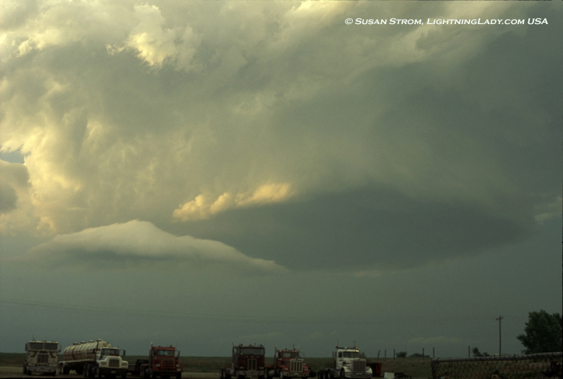
I like this little one because he was green. This was May 31, 1999 in Woodward, Oklahoma. It doesn't deserve the bad-boy supercell prize, maybe just the Kermit the Frog award.

I had to ask a gentleman who was working in an industrial yard if I could drive onto and shoot from his property. He said, "Shoot what?" I pointed up, as the meso was spinning above. He came out of his shed and looked up with an expression of awe on his face. He had not noticed the passing meso nor heard the NOAA warnings because he was busy working with powertools, concentrating heavily on something in his workshop. I drove to the back of his industrial yard to take the pictures. Another fine day in the Oklahoma Panhandle :)

LLWoodward.jpg

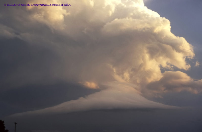
LLTailcloud.jpg
 
The May 29, 2004 supercell that tracked all the way across Oklahoma could possibly win points for: One or more anticyclonic tornados produced & Strongest RFD wind which technically might be one of the strongest wind gusts but probably not. Its life span was about 12 hours and it produced baseball and larger size hail too but I dont think either of those will be enough to bring points. I will try and find specifics later unless someone already has!

Heres my report on it:
http://www.realclearwx.com/calumet.htm

And base reflectivity from when it was passing near OKC:
http://www.realclearwx.com/okc.mov

Thanks for the radar echo on this beastie, an HP with a classic structure. I've never been in a storm that almost pushed me off the road with an RFD wind gust in excess of 100mph as this one did. I've never seen inflow so powerful that it was ripping dust out from fields for at least 10 miles out and pulling it up into the MESO. With 5" diameter hail and from what was left from the windshields of some of the other chasers out their this is one core I refused to punch. After we tracked this storm into Oklahoma City it was simply too dark to see important features that could pose a safety risk (tornados:eek: ) so we ended the chase and stayed for the night.
 

Attachments

  • 004-.jpg
    004-.jpg
    42.1 KB · Views: 82
  • 005-.jpg
    005-.jpg
    38.6 KB · Views: 89
  • 000-.jpg
    000-.jpg
    30.4 KB · Views: 91
  • 007-.jpg
    007-.jpg
    29.1 KB · Views: 95
I was thinking of this storm (5/29/04, OK) as soon as this thread appeared. In addition to the RFD and anti-cyclonic tornadoes, the hail was huge. I saw 4-inch stones on the ground, and Storm Data includes reports of 4.75 and 4.25. It also confirms at least 2 anti-cyclonic tornadoes, and mentions a third "from the same cirulation" that produced the first two.

Here is some video I got of anti-cyclonic rotation which may or may not have been associated with the second or third tornado:

http://www.youtube.com/watch?v=k1dZpW5aFFk

This rotation occurred after the first anti-cyclonic tornado; video was taken from ENE of Calumet looking N or NNW. I could not tell whether or not this was a tornado; I did not see any ground circulation but as you can see in the video, there were trees in the way. As you can hear, I had the radio on and was getting constant updates on the storm from Gary England. This is, incidentally, my first post to You-Tube.

I missed the first tornado, shown in David's photos linked above and documented by many chasers, because I was trying to catch up with the storm from the west after earlier going after the next storm north (which formed earlier), and I then had to detour south to I-40 due to the lack of a river bridge anywhere but I-40. When you put together the hail, the anticyclonic tornadoes, the RFD, and the amazing inflow, this was definitely a supercell to remember, even though the more photogenic tornadoes that day occurred to the north in Kansas.
 
Last edited by a moderator:
Though it didn't produce violent tornadoes, the longevity of the 3-12 Mega-cell seems an approtiate pick. It traversed across across six states (four with supercell characteristics). It's duration was around 14 hours long and it produced 14 tornadoes, three of which were long-track. I don't have the exact speed but I know it was moving at a pretty good pace. It had two tornadoes on the ground at times and may have had a brief period where there were three on the ground (per STL assessment).
 
Last edited by a moderator:
Also, just to the south of that highly impressive supercell was perhaps an even more impressive supercell that was well observed during the BAMEX field campaign:

http://ams.allenpress.com/perlserv/?request=get-abstract&doi=10.1175/BAMS-85-8-1095

118 m/s velocity differential observed in that mesocyclone that produced the deadly Deschler tornadoes that evening. Therefore, apparently it was the most intense mesocyclone ever measured. Also, it was sized at about 9 km, apparently the largest mesocyclone recorded.

I completely agree with recommendation offered by Mr. Rozoff. However, for the record the mesocyclone discussed by Wakimoto et al. was not associated with the Thayer Cnty (Deshler) tornadoes. Additionally, the storm was NOT well sampled by BAMEX as only the Eldora made it to Nebraska, and late to boot (as written by Wakimoto et al.)!

--Al
 
So many to choose from....I think the biggest/baddest supercell of them all was the N.Kansas (Plainville -Beloit KS) one on June 15, 1992. This one seemed to be a breathing entity with tremendous size and organization. A second would be the nasty monster that terrorized the Grand Island area June 3, 1980. That one was like a merry-go-round of trouble. Whether or not one of these menacing supercells makes an appearance remains a big question mark. It seems that June setups make the ideal sustainment conditions for these types of extreme maxi-supercells.
 
So many to choose from....I think the biggest/baddest supercell of them all was the N.Kansas (Plainville -Beloit KS) one on June 15, 1992. This one seemed to be a breathing entity with tremendous size and organization. A second would be the nasty monster that terrorized the Grand Island area June 3, 1980. That one was like a merry-go-round of trouble. Whether or not one of these menacing supercells makes an appearance remains a big question mark. It seems that June setups make the ideal sustainment conditions for these types of extreme maxi-supercells.

June 15, 1992 has my vote. I have an old video (can't confirm the accuracy) which claims this particular storm produced over 25 tornadoes before they stopped counting. I can't think of any individual storm in recent history doing that.
 
June 15, 1992 has my vote. I have an old video (can't confirm the accuracy) which claims this particular storm produced over 25 tornadoes before they stopped counting. I can't think of any individual storm in recent history doing that.

Scott, Brian....who has good video or stills of this storm? I keep hearing how outrageous it was (I was in Virginia at the time). Gene Rhoden has a few tornado shots, but I have yet to see anything that dramatic. Were all the tornadoes hard to photograph, in the rain or late in the day? There is almost nothing online about it....of course people pull their old chases to save bandwidth. It would be great if chasers that witnessed these great storms of the past came on and showed pictures/ video captures, told their stories. I'm sure they were the topic of storm chaser picnics back then, but many of the people here never saw that material.

Gene Moore

Maybe Moller or Prentice can chime in. Maybe Moller wasn't even on it but was just describing what he heard about it...I'm not sure. It seems like he was talking about it, recounting what he'd seen.

On Prentice's video it looked like a big beast at one point.
 
Scott, Brian....who has good video or stills of this storm? I keep hearing how outrageous it was (I was in Virginia at the time). Gene Rhoden has a few tornado shots, but I have yet to see anything that dramatic. Were all the tornadoes hard to photograph, in the rain or late in the day? There is almost nothing online about it....of course people pull their old chases to save bandwidth. It would be great if chasers that witnessed these great storms of the past came on and showed pictures/ video captures, told their stories. I'm sure they were the topic of storm chaser picnics back then, but many of the people here never saw that material.

Gene Moore

Here is some informaton I found... ( http://www.intellicast.com/Almanac/SouthCentral/June/ )

June 15, 1992
  • The second largest two-day tornado outbreak in U.S. history commenced as a developing cumulus cloud broke through the cap in north central Kansas and exploded into a huge supercell thunderstorm. Between 4:15 and 8:35 pm cdt, this supercell produced 39 tornadoes in north central Kansas, including 12 in Mitchell County and 9 in Osborne County.
According to Sam Barricklow's account on his website...( http://www.k5kj.net/19920615.HTM )

"...including huge hail, high straight-line winds, deadly lightning and numerous tornadoes, the largest of which was almost 1/2 mile wide southwest of Concordia, northwest of Delphos. The complex consisted of multiple supercells existing simultaneously in a connected multi-flank supercell complex. Supercell (rotating) updrafts were located on the east, south and southwest flanks of this complex."

Now that sounds incredible!
 
Jeff Piotrowski and David Payne were on this monster supercell and got some pretty crazy stuff as they tracked it from the Plainville area over towards the Tipton and Beloit KS areas. This was a monster supercell, and certainly the most memorable supercell I can recall.
 
Back
Top