So I assume these signatures are enough to call this a tornado?

sam.leisenring

Enthusiast
Joined
Apr 14, 2019
Messages
6
Location
Rochester, NY
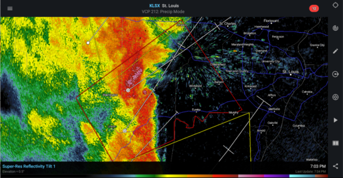
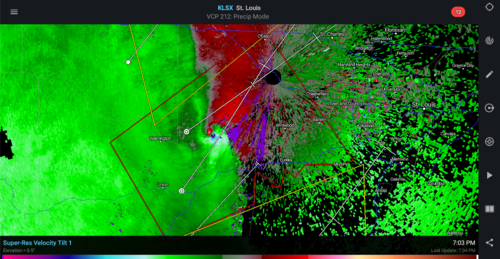
I'm sorry if this is a really dumb question but i'm not very experienced with this stuff. But by my judgement this appears to be a very big tornado based on the visible debris ball on base reflectivity and on CC and then the giant velocity couplet. The warning on this storm sayid that a tornado was confirmed by weather spotters, but I was just wondering if the NWS would be confident in calling this a tornado if there wasn't any visual on the ground.
18248
18247
18246
 
Confirmed large and extremely dangerous tornado on the ground. Confirmed by spotters, and is rain wrapped.

And no, that isn't a dumb question, Sam.
 
... by my judgement this appears to be a very big tornado based on the visible debris ball on base reflectivity and on CC and then the giant velocity couplet. The warning on this storm said that a tornado was confirmed by weather spotters, but I was just wondering if the NWS would be confident in calling this a tornado if there wasn't any visual on the ground.
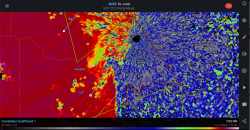
Yeah. Here's a link of google results that show warnings with "radar confirmed tornado" in the text, on weather.gov. You can see it's not all that uncommon that they do that. CC can secure most confidence, and it's icing on the cake that the scan is so close to the ground (~500-700ft).

The Warning Decision Training Branch has some fairly in-depth tutorials regarding this, uploaded for anyone to watch:
- WTDB: Warning Operations Course - Severe Track

* Check the 'Tornado Warning Guidance Lessons' under "Tornado Curriculum." I need to do the same. This is enlightening stuff.
 
Concerning this specific tornado, I had a chat with the NWS St Louis guys on Twitter, and they said that this tornado was indeed very much confirmed by radar. They were calling it a 'considerable-threat tornado' due to the close proximity to a large, populated area. Despite the scary-looking TDS on the correlation coefficient, it only turned out to be a weak tornado that caused mainly tree damage. However, that was one of the most pronounced radar-confirmed tornadoes that I have ever seen, and I have no doubt that it was more intense than an EF-1. The only more pronounced signature I've seen since then was the Elk Mound EF-3 from last September.


Here's the NCDC Storm Database summary of this event:

"After crossing the Missouri River into St. Charles County, the tornado uprooted and snapped off numerous trees on Sanders Road and caused extensive damage to a farm outbuilding. Further northeast as it crossed Terry Road, where it caused extensive tree damage. As it continued northeast it caused minor structural damage on a barn and outbuilding on Coates Lane, before causing minor roof damage to a house as well as snapping off several trees. The tornado lifted and dissipated just southeast of the intersection of Coates Lane and Duke Road. This portion of the tornado was rated EF1 with a path length of 4 miles and a max path width of 250 yards. Overall the tornado was rated EF1 with a path length of 5.94 miles and a max path width of 250 yards. No deaths or injuries were reported."
 
Back
Top