• While Stormtrack has discontinued its hosting of SpotterNetwork support on the forums, keep in mind that support for SpotterNetwork issues is available by emailing [email protected].

Shelf Could or Mesocyclone? Or both?

Joined
Oct 14, 2008
Messages
300
Location
Lake Tahoe, CA
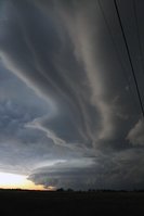
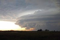
Hey ST Crew, I had a picture from 3-25-15 of the supercell over OKC when the Moore tornado was on going, and I was hoping to get a little help with feature identification. I have attached 2 images (I hope. I've never attached images before, so I don't know what's going to happen here). As you can see, the images contain the striations of a shelf cloud and gust front from the leading edge of the storm in the distance over Moore (I am looking west southwest from highway 177 north of I-40). However, the second image focuses in on the area that should contain the mesocyclone that helped produce the Moore tornado. So my question is where is the rotating mesocyclone? Is it embedded within the leading edge shelf cloud? Is that cavity, above the shelf cloud that has the bulbous clouds and lighter blue color, the updraft and therefore the meso is around there? Is the shelf cloud the mesocyclone?
00000256.jpg


00000261.jpg
 
I think you are looking at a line of thunderstorms. I think that complicates it a bit. The rotations were more in the front of the storms I too.
 
Yeah, my guess before the people who know what they're talking about get here: There is no mesocyclone in that photo. It is strictly shelf, with the bright area above it being the storm's mid-level inflow. It would be mid-level, because the storm is mostly out-flow dominant at that point at ground level, forcing the warm air ahead of the storm aloft a bit. The tornado was generated from a smaller-scale mesovortex rather than a classic mesocyclone.
 
Whats the timestamp of the image? Image 2 looks much more like a conventional, but outflow dominant High precip rear flanking downdraft. The Moore tornado was produced from what seems like a confluence of a boundry and perhaps the rear inflow jet causing a spin...while a separate small updraft connected to the southern arm of the RFD helped stretch this week confluence into a tighter circulation or handful of week circulations. This is an odd "tornado" for a lot of reasons.

I think its just a really odd coincidence of a new updraft forming on the leading edge of another storms' RFD, right at a boundry. Just fascinating really.
 
Unfortunately, no timestamp. However, now that I've read the Events page for 3-25, I see that Skip posted about the mesovortex. I also noticed that my picture is not during the tornado. I took it around 6:55 when it was tornado warned. First there were two tornado warning boxes: one on the southern half of the storm one of the northern half of the storm. Then they removed the northern box. So I took the pictures when they had the two boxes. But apparently that's after the tornado dissipated. So my photo is a good 10 minutes post-tornado.
 
Back
Top